
-
 26277 Hits
-
 80.49% Score
-
 12 Votes
|
|
Mountain/Rock |
|---|---|
|
|
28.71705°N / 13.89268°W |
|
|
Hiking |
|
|
889 ft / 271 m |
|
|
Overview
 The Volcan Bayuyo eastern crater The Volcan Bayuyo eastern crater |
The north of Fuerteventura is best known for its surf (west coast) and its beaches (east coast. Therefore it is one of the two large tourist centres of the island (Morro Jable in the south being the other one) and FuerteVentura's northernmost town, Corralejo can tell you a bit about the excesses caused by tourism. Around its old centre, a fisher village, big hotels and settlements have been built and straight lines dominate the area. As a backdrop, however, there is a huge volcanic area, with a number of volcanoes rising out of the lava fields around. The northernmost of these volcanoes is Volcan Bayuyo, rises directly above Corralejo (and - one must confess - above the city dumps as well).
The area south of Corralejo belongs to the part of the island where the latest volcanic eruptions took place. In two separate rifts volcanoes erupted about 10.000 years ago, covering the north of the island with lava fields and ashes. The eruption of Volcan Bayuyo, extended the size of the island considerably. The volcano emitted lava from two craters, covering the whole north and extending the island by 100 square kilometres. Bayuyo is accompanied by a handful of slightly older volcanoes, which forms a line, stretching from north-east to south-west and ending in two colourful volcanoes, Montaña Colorada and Calderon Hondo.
 |  |  |
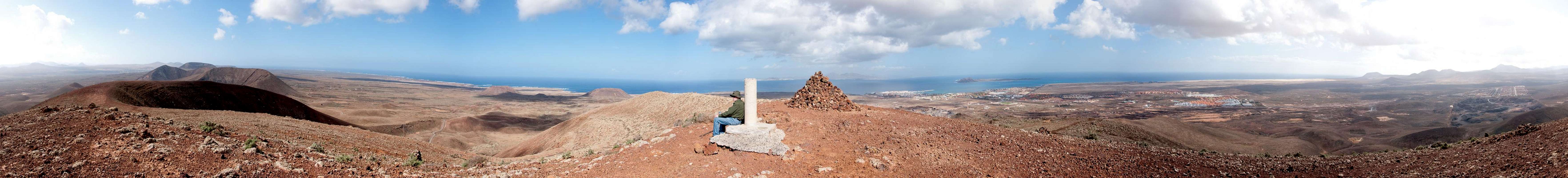
Volcan Bayuyo has two craters of almost equal size, one opening to the north-west, the other to the north-east. The main summit is located on the thin ridge between the craters and though it only reaches 217m, it commands wonderful views toward the islands of Lanzarote and Los Lobos as well as the surrounding smaller volcanoes. Indeed - in reverse - Volcan Bayuyo is the first sight you see from these other islands.
 |  |  |
There are two paths to the summit, the northern one of which follows the western rim of the eastern crater. It is a rather scenin route as views develop as the path rises above the lava fields. However, it is also very steep and in combination with the heat you often encounter here, it is much more demanding as you would expect from a mountain this size. The second route follows the western rim of the western crater. It is less steep though harder to find as the tracks are less pronounced.
 Caldera Encantada (263m), Calderon Hondo (278m), Las Calderas (248m)
The climb to Bayuyo's summit along the northern path is the first stage of a beautiful traverse which includes all volcanoes along the old rift line. Besides Bayuyo you cross the summits of Las Calderas, Caldera Encantada, Calderon Hondo and Montaña Colorada.
360° Summit Panorama
  |
Getting There
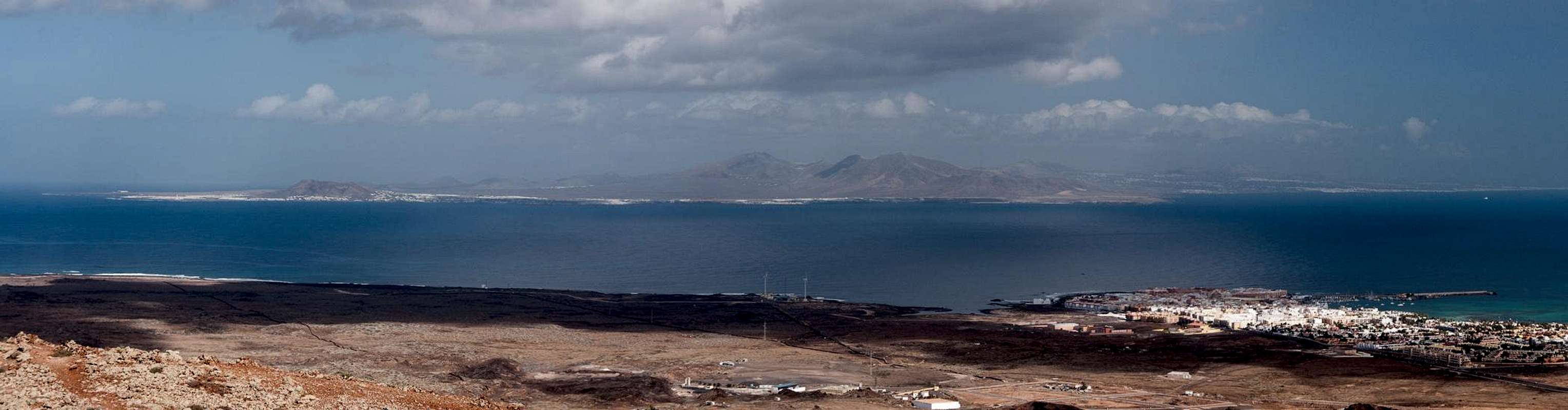
 Isla de Los Lobos seen across Corralejo
Though there are ferries from the Spanish mainland to the Canary Islands, they take more than 24h for the trip. Therefore almost all visitors go by plane. Every travel agency in Europe offers flights, hotel rooms, apartments, rental cars etc. so that reaching the Canaries is rather a matter of money than opportunity. During the summer season flight fares can be reasonable but during the Easter and Christmas holidays you have to be prepared for additional fees of 500€ per person.
Fuerteventura has its own airport south of the capital Puerto del Rosario close to the center of the island. There are public bus lines but – like on all the islands – they don't run too regularly. If you plan to stay on your own, better take a rental car right at the airport.
The shortest ascent to Volcan Bayuyo starts at Corralejo, the northernmost village / town of Fuerteventura. It can be easily reached from the airport near Puerto del Rosario by taking FV-2 north, then using FV-3, the ring road around the capital Puerto del Rosariowhich turns onto FV-1 to Corralejo.
Red Tape
There's no Red Tape here. The Malpais de Bayuyo, one of Fuerteventura's youngest and largest lava fields should be explored by the paved cobblestone paths only. The lava is brittle and easily breaks apart when you step on it, resulting in a severe danger of injuries. Moreover, orientation in the lava fields can be difficult.Accommodation
 |
For holiday homes, hotels or apartments either consult your nearest travel office, or – search for lodgings on Google. There are several sites on the web, dedicated to rent privately owned houses or apartments. Prices are generally a bit less expensive than for tour operators but you don't have as much security.
Corralejo is the nearest tourist centre and there are several "urbanisations" on the road between Villaverde and Corralejo. In Villaverde and La Oliva quite a number of central and north European expatriates have built their summer homes which often are for rent privately.
Weather Conditions
Fuerteventura is usually swept by fierce north-western trade winds. Though they deposit their humidity on almost all of the other Canary Islands, Fuerteventura (as well as Lanzarote is simply too low to form a decent obstacle. Therefore the climate is very arid. However, winds regularly are pretty strong, especially on the mountaintops. It pays to take warm wind-stopping clothes with you.For some time of the year, eastern winds prevail, which almost always carry clouds of Sahara dust with them. Usually this means reduced visibility but in some occasions "Kalima" occurs. Fierce storms take up the dust from the Sahara and sweep it across the islands. In these times visibility is nil and sometimes even airplanes have to be grounded.
Maps & Books
Maps
Regular Maps
- Fuerteventura
Kompass Map WK240
Kompass Verlag
1:50000
ISBN: 978-3-85491-174-6
Digital Maps
Kompass is the only company known to me which offers GPS digital Maps. In addition for those of you with Garmin GPS receivers there is a map source map set of all Canary islands out there.
- Fuerteventura
Kompass GPS4240
Kompass Verlag
ISBN: 978-3-85491-222-4
- Islas Canarias
Map Source custom map
By Manfred Pepper
downloadable zip-file
Books
My recommendation is a guidebook by Rother Verlag, available in German. The book is an excellent hiking guide covering all the interesting areas of the island. Since it comes with small maps for each excursion it might even be used without a map to support them.
- Fuerteventura
Rolf Goetz
Rother Verlag
ISBN 978-3-7633-4303-2