
|
|
Mountain/Rock |
|---|---|
|
|
46.04479°N / 10.67228°E |
|
|
Trentino |
|
|
Hiking, Scrambling |
|
|
Spring, Summer, Fall, Winter |
|
|
7014 ft / 2138 m |
|
|
Overview
Monte Cengledino 2138 m
The Valli Giudicarie, subdivided in Esteriori and Interiori, are a mountainous area located at the SW end of the Trento province and including the high basin of the river Chiese and the basin of the river Sarca. The highest point of the territory is Cima Presanella at an altitude of 3558 m. Monte Cengledino, named also Camp Antic, is a minor summit appreciated for the position and the wide panorama, situated in the Giudicarie Esteriori, on the south-eastern foothills of the Adamello Group. It is a classic and quite popular destination, both for summer hiking, ski mountaineering and the winter ascents with snowshoes.
Getting There
The closest town is Tione di Trento.

Road access to Tione
- from Trento take the road SS 45bis across Vigolo Baselga and Vezzano until Le Sarche. At the roundabout in Le Sarche take the road SS237 to Tione. At the roundabout in Tione turn left and go to the traffic light located south of the town. Turning right to Piazza Guido Boni, then onto Via dei Monti then Via Piave, following the signpost for Zeller. It begins the 9 km. long paved road leading to Zeller. At the fork after the restaurant Primula in loc. Maftina, turn right at a bend at about 1100 meters of altitude. After reaching Zeller, continue until you reach the Refuge Zeller parking area 1347 m, from where it begins the ban to non-authorized vehicles and the road enters the woods.
- from Brescia follow the Caffaro road SS237 to Tione then as in the previous point. A shortes possibility to reach the Zeller Refuge coming from Brescia: once in Breguzzo, turn left along the road to Val di Breguzzo. Go up for about 3 km to Limes; turn to right at the restaurant and continue along the asphalt road up to Le Sole. Continue slightly downhill to the Madonna del Monte, turn left and go up to Zeller.
Monte Cengledino SE ridge

Monte Cengledino SE ridge
Summit quote: 2138 m
Difficulty: E
Difference in level: 790 m from Refuge Zeller
Starting point: Refuge Zeller m 1347
A basic route to get the summit of Cengledino
From the car park at the altitude of 1347 m, follow the road that winds through the wood, rising up with some hairpin bends, with the possibility of shortening the route by following the track that rise in the wood between one hairpin and the other. Reached a hairpin bend to the right it begins a large meadow uphill, here leave the road and continue on a track in the meadow up to the clearly visible Malga Cengledino.

|

|
When you reach the hut, go straight on until you reach the large parking area above the hut at an altitude of 1678 m (bench and signposts). At the wooden signposts near the park head to left following the well worn path n. 235 (Monte Cengledino) crossing through the wood, then skirting the steep East slopes of Monte Cengledino.

|

|
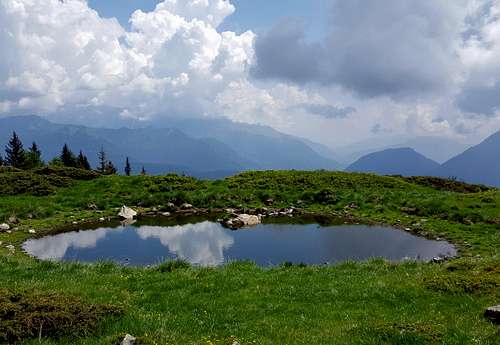
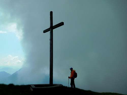
After the long cross the path reaches a small mountain pasture puddle, where it begins to climb definitely always to the left direction to reach the wide South East ridge of the mountain. Following the ridge with a decisive ascent you reach the panoramic summit (cross). The only drawback: the television antenna next to the cross!
Descent: reversing the itinerary
Monte Cengledino and Laghi di Valbona
Monte Cengledino across Baita Fontana delle Laste and Laghi di Valbona
Summit quote: 2138 m
Difficulty: E
Starting point: Refuge Zeller m 1347
It's a longer way to get the summit across a beautiful landscape

You reach Malga Cengledino as reported in the previous point. At the wooden signposts in the parking lot above the alm, take on the right the path 225 to the Bait Fontana delle Laste and Laghi di Valbona, which proceeds in a North-West direction. After about 45 minutes we arrive at the Bait Fontana delle Laste. The path rises along the valley skirting the slopes of Monte Cengledino. After crossing some debris, it begins to appear the lowest of the Valbona Lakes. After about ten minutes the path takes us close to the two oblong median lakes of Valbona. We pass a spring with a trunk to act as a source and after a little less than half an hour uphill we arrive at the Upper Lakes of Valbona m.2370. Leave the path n. 225 and turning left climb up the northern flank of Monte Cengledino to get the watershed with the Val Breguzzo at about 2420 m. The remaining route runs south-east, along a grassy ridge that leads down to the lower Cima Cengledino. Accompanied by a magnificent view to the north over the Craper of Stracciola towards the Carè Alto and the Crozzon di Lares, on the beautiful Lakes of Valbona, towards the southwest on the Val di Breguzzo and the Giudicarie Esteriori. We arrive at the large wooden cross at the summit of Cengledino.
Descent: following the SE ridge (see the previous route) we return to Malga Cengledino
Red Tape
No fees no permits required
Hiking and scrambling scale
T - Turistico (Tourist): Itineraries on wide, clear and well worn paths, sometimes on mule tracks or gravel roads. The routes are never exposed, don't give any orientation problems and don't exceed 2500 meters of altitude. Suitable also for children
E - Escursionisti (Hikers): Itineraries on marked trails, even narrow and with possible steep and impervious sections. They are never exposed and don't give any orientation problems. They can tread different kinds of ground, such as forests, gravel, meadows, pastures, easy rocks, etc.). They form the majority of the trails that wind up in the mountains and require a certain habit to walk; you need equipment suitable for the altitude and resistant footwear with soles suitable for rough terrain
EE - Escursionisti Esperti (Experienced Hikers): Itineraries for hikers with experience and good knowledge of the mountain. Some of these paths may have exposed sections, however brief, which require firm foot and no dizziness. They require the ability to adapt to particular terrain, such as steep grassy slopes or stretches of rocks with difficulties that can reach the 1st degree of the UIAA scale. They can also reach high altitudes (3000 m or more). Sometimes they may include unmarked sections, requiring a good sense of orientation. Snow slopes are possible, however which can be overcome without specific mountaineering gear (rope, harness, crampons, ice-axe)
EEA - Escursionisti Esperti con Attrezzatura (Experienced Hikers with equipment - The same as EE, in addition these routes require the use of via ferrata equipment (lanyards, harness, carabiners, heat sink, helmet). This kind of itineraries range from the trails with short easy and not much exposed sections, previously equipped with fixed ropes and iron pegs, to the true and more difficult Via Ferratas climbing on rocky walls or on aerial ridges and ledges, previously equipped with long stretches of iron ropes, iron steps, ladders without which proceeding would constitute a real climbing. It is necessary to know how to use the technical equipment and have a certain habit of exposure and mountaineering terrains.
When to Climb
All year round. Winter ascents require the use of specific equipment.
Accomodation
Different possibilities of accomodation in Tione
Bibliography
"Adamello-Presanella" - 4LAND foglio 138, Scala 1:25.000
"Adamello-Presanella" - Kompass foglio 71,Scala 1:50.000