
|
|
Mountain/Rock |
|---|---|
|
|
10.67368°N / 61.39775°W |
|
|
Hiking, Mountaineering |
|
|
Spring, Fall, Winter |
|
|
1808 ft / 551 m |
|
|
Overview
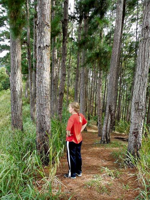
Mount Tabor is in the Northern Range of Trinidad and above the Mount St Benedict Monastery. Unfortunately the trails to the summit have been overgrown and some old guidebooks are out of date. In order to reach the true summit, bushwhacking is required and many of the plants are razor sharp, thorny, or sting like h___. Luckily the trail through the pine forest to the fore summit is quite pleasant and the views are good (and in fact are better from the fore summit than the main summit).
The fore summit provides views all the way from Port of Spain to Arima as well as much of the Central Range.
The area is rich in birdlife and there is much other wildlife as well. We saw many birds including some huge vulture like birds on the mountain. There are ruins of an old monastery on the summit, but there isn’t that much left.
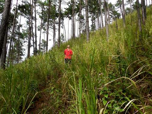 These are the lower and more pleasant slopes of Mount Tabor on Trinidad. It is going to get a lot more difficult higher up!
Getting There
The trail starts at the Mount St Benedict Monastery, which is about 14 kms/9 miles east of Port of Spain. You can reach the area from Arima or Port of Spain.
From either Port of Spain on the west or Arima on the east, take the bus, taxi, or a car to St Augustine on the Eastern Main Road. Turn north on St Johns Road just west of Scotia Bank. Route taxis leave for the monastery from the opposite of Scotia Bank every few minutes. There are also sporadic buses from Curepe.
If driving, from St Johns Road near Scotia Bank, follow the road past the UWI School, and to the end of St Johns Road. There is a private road to the left which is the road to the monastery. Proceed up the road to the monastery.
The trailhead is not at the main complex of the monastery. Avoid following the sign to the church. Continue straight uphill to some switchbacks. Pass the Drug Rehabilitation Center and past Benet Hall at Top of the Mount. The trail begins here. If taking a bus, backtrack from the main monastery complex and find the Drug Rehabilitation Center and follow the directions above.
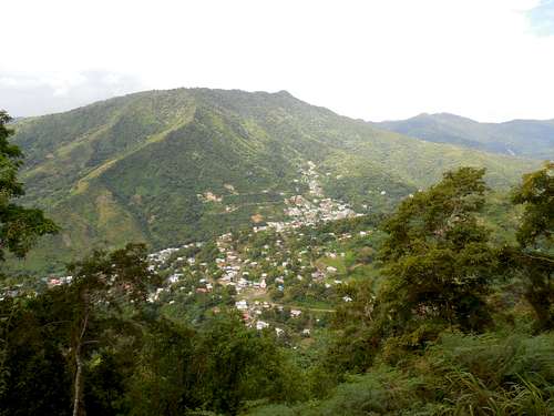 View from the slopes of Mount Tabor.
Route
From Top of the Mount, follow the short paved road that ends at the Sanctuary. Continue along the trail past a radio reflector on the right. The trail climbs steeply to an old fire lookout. From the fire lookout the trail continues through a beautiful pine forest to the fore summit. There are a few old rest benches along the way.
You may wish to turn around at the fore summit, which has the best views of the hike. If you choose to climb to the true summit, there are scraps of old trail visible at times and the occasional ribbon on a tree, but the route is a difficult and time consuming bushwhack with many sharp, thorny, or stinging plants. I would not repeat it. Good luck!
 View from the slopes of Mount Tabor.
Red Tape
There is no red tape, but make sure to be respectful since you are monastery land.
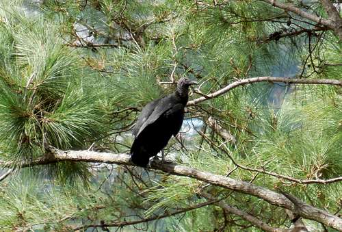 Some kind of huge vulture in the tree on Mount Tabor.
When to Climb
anuary through May is the “dry” season, with February through April being the driest. December is an in between season. June through November are very wet and especially July and August. Even in the so called dry season, prepare for possible rain.
Although prices in Trindad aren’t as effected except during Carnival, if you are visiting Tobago on the same trip, prices sky rocket between mid-December and mid-April. Carnival in Trindad is in February or March depending on the year. If going to Trinidad during Carnival, make sure to book accommodation far in advance. Even though a bit wetter, early to mid December and May can be good months to climb since it’s not tourist season.
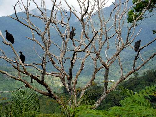 There were many of these huge vultures in the trees on Mount Tabor in December 2013.
Camping and Accommodation
There are places on the mountain where people have camped, but you will have to take your own water. If you do camp, be very respectful and leave a clean campsite. Near the trailhead and a part of the monastery is the Pax Guesthouse. It is very reasonably priced. Their website contact is below:
Pax Guest House
You can also stay in Arima or Port of Spain.
Mountain Conditions
Weather averages for Brasso Seco are below, but the mountains will be a bit wetter and cooler than Brasso Seco.
CLICK FOR BRASSO SECO WEATHER FORECAST
| Month | High (° F ) | High (° C) | Low (° F ) | Low (° C) | in. Rain | mm Rain | Rain Days |
| Jan | 88 | 31 | 70 | 21 | 2.98 | 75.6 | 21 |
| Feb | 88 | 31 | 70 | 21 | 1.70 | 43.2 | 18 |
| Mar | 90 | 32 | 72 | 22 | 1.14 | 29.0 | 14 |
| Apr | 91 | 33 | 73 | 23 | 2.28 | 58.0 | 14 |
| May | 91 | 33 | 75 | 24 | 3.97 | 100.8 | 20 |
| Jun | 90 | 32 | 75 | 24 | 9.20 | 233.7 | 25 |
| Jul | 90 | 32 | 73 | 23 | 12.13 | 308.1 | 26 |
| Aug | 91 | 33 | 73 | 23 | 11.16 | 283.5 | 25 |
| Sep | 91 | 33 | 73 | 23 | 9.37 | 238.1 | 22 |
| Oct | 91 | 33 | 73 | 23 | 6.86 | 174.2 | 22 |
| Nov | 90 | 32 | 73 | 23 | 7.87 | 199.8 | 25 |
| Dec | 90 | 32 | 72 | 22 | 4.72 | 119.9 | 22 |
Guidebook
It isn't cheap, but if you plan on doing much hiking in Trinidad and Tobago, The Trinidad and Tobago Field Naturalists' Club Trail Guide is a very valuable resource.
The Trinidad and Tobago Field Naturalists' Club Trail Guide
The guidebook is currently out of date on the Mount Tabor Hike, but it is a very good source for hiking in Trinidad and Tobago.
JJ868 - Jan 13, 2021 2:53 pm - Hasn't voted
Wrong Geographic LocationThe twin island Republic of Trinidad & Tobago is NOT in South America. Though geographically positioned next to Venezuela, which is in the South American continent. Trinidad & Tobago makes up part of the archipelago of Caribbean islands. Therefore making it apart of the Caribbean. Also, Mt. Tabor is located on the Northern Range of Trinidad and NOT the Central Range as mentioned in this article.
Scott - Jan 13, 2021 3:18 pm - Hasn't voted
Re: Wrong Geographic LocationRight you are about it not belong to the Central Range. I made the change. The Caribbean isn't a continent, but is often lumped in with North America, though Trinidad is out of place in North America. Geographically and geologically Trinidad belongs to South America because it is an extension of the Andes Mountains. Anyway. thanks for the comments.