
-
 56997 Hits
-
 79.04% Score
-
 10 Votes
|
|
Mountain/Rock |
|---|---|
|
|
43.70030°N / 74.3864°W |
|
|
3899 ft / 1188 m |
|
|
Overview
At 3,899 feet, Snowy Mountain is the highest peak in the Adirondacks south of the High Peaks region and the eighth-most prominent peak in New York with 2,225 ft of prominence. Despite not being part of the prestigious Adirondack 46 high peaks, Snowy is actually higher than Nye and Couchsachraga which were originally believed to be above 4,000 ft. While the summit of Snowy Mountain is below treeline and mostly forested, there is a fire tower atop the summit that gives climbers a 360-degree view. On a clear day, one can see the Adirondack high peaks to the north, Indian Lake which lays adjacent to the east, Lake Pleasant, Sacandaga Lake, Piseco Lake, the Siamese Ponds Wilderness, and the West Canada Lake Wilderness.
The fire tower on Snowy Mountain was originally erected in August 1909 in response to a series of fires in the Adirondacks in years prior. The original temporary fire tower was later replaced in 1917 with a steel tower. Other than a modification in the 1930s to extend the height of the tower, the 1917 steel structure remains standing today and was added to the National Register of Historic Places in 2001.
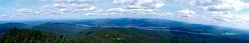 Summit panorama Summit panorama |
Routes
The standard hiking route up Snowy Mountain is a DEC-maintained trail that ascends starting from a trailhead on NY Route 30. While a sign at the trailhead lists the distance to the summit as 3.4 mi, most topographical maps and other resources list the distance as being 3.9 miles with a total elevation gain of 2,106 ft. The trail to the summit begins as a pleasant and easy walk with very moderate elevation gain in the first 2.5 miles, but the trail gets rather steep towards the end, gaining about 1,300 ft of elevation in a little over a mile. Your hard efforts along this upper portion of the trail are rewarded with a large flat clearing shortly below the actual summit which offers an excellent view of Indian Lake and the Siamese Ponds Wilderness to the east and south. Another 0.2 miles past the large clearing are the summit and fire tower. At the large clearing, one can head due west on a herd path to reach a rock ledge with gorgeous views to the northwest.
In the last 10 or 15 years, a series of rock climbing routes have been established on Snowy’s open rock faces on the south side of the mountain. A separate trail to the base of the rock faces used to exist that started south of the main trailhead on NY-30. However, this trail is now mostly overgrown with much debris covering the trail. Rock climbers seeking the base of the faces are now advised to take a herd path that diverges to the left from the main trail shortly before reaching the large flat clearing below the summit. The most comprehensive guide on rock climbs is the book Adirondack Rock by Jim Lawyer and Jeremy Haas.
| Route Name | Rating | Type |
|---|---|---|
| In The Buff | 5.7+ | Sport, 1 pitch, 50 feet |
| Iditarod | 5.8+ PG13 | Sport, 3 pitches, 400 feet, Grade II |
| Buckwheat | 5.9- A0 | Sport, Aid, 2 pitches, 120 feet |
| Vertebrae | 5.9 | Sport, 2 pitches, 240 feet |
Getting There
Snowy Peak is in the Central Region of Adirondack State Park. The trailhead is on NY Route 30, approximately 6.5 miles south of the village of Indian Lake, New York. There is a parking lot directly across Route 30 from the trailhead.
Red Tape
No permit is required to climb Snowy Mountain. There is a trail register just in from the road.
When To Climb
Snowy can be climbed in any season. The steep last mile would make for a fun winter climb.
Camping
There really aren't any good camping areas along the trail itself, save perhaps for the clearing on the summit when you emerge from the trail. Even the trailhead area is wooded and separated from the small parking area by Route 30. At 7.5 miles round trip, however, camping along the trail is probably not an issue.
Mountain Conditions
Not being part of the High Peaks or a 46er, there really isn't online information devoted directly to Snowy, but you can check weather conditions for Indian Lake or Sabael, NY. Snowy is in the Central Region of the Adirondacks, so bear that in mind if you're searching the Adirondack climbing resources on the web for current conditions.
gordonye - Dec 1, 2003 7:37 pm - Hasn't voted
Untitled CommentLatitude and longitude should be in decimal degrees:
Lat = 43.7003 deg. (N)
Long = -74.3889 deg. (W)
according to your numbers. Try the "Distances" link on the left.
Rob A - Mar 2, 2005 4:38 pm - Voted 10/10
Untitled CommentThe two times i have climbed Snowy, i made both trips over-nighters. Thier are 2 camp sites (non offical) ABOUT 1/2 mile from the teail head.
Also camping on the summit is fun. it is the 8th highest mountain you can camp on and on clear mnorings and day's it has views to the High Peaks.
Pleas if you camp on top and make a fire do it on the big rocks at the clearing by the summit. (look at my picture of the tent on the ledge, those rocks) and make a fire ring. put drit on the bottom of it and when you are done put the rocks back and disperse the dirt. You know, "Light is Right" and all.