
|
|
Mountain/Rock |
|---|---|
|
|
35.65420°N / 83.4369°W |
|
|
6593 ft / 2010 m |
|
|
Overview
Mt. LeConte is located within Great Smoky Mountains National Park. At 6593 feet, it is the third highest peak in the park and the sixth highest in the whole Appalachian chain. The mountain rises abrubtly from east side of the French Broad River Valley in Tennessee approx. 30 miles south-east of Knoxville. The summit towers nearly a vertical mile above its western base near the busy tourist town of Gatlinburg. The mountain actually sits about 2 miles north of the main ridgeline of the Smokies, connected to Mt. Kephart by a ridge known as the Boulevard.
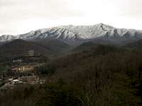
LeConte Towers Over Gatlinburg, TN
The Smokies are the most visited National Park in the country but remarkably few people actually venture any distance from US-441, the road which bisects the park. This doesn't mean you will have the peak to yourself but don't let the traffic jam scare you. The shortest round trip to the peak is nearly a 10 mile trip, long enough to weed out most Birkenstock-clad tourists. Unfortunately, however, you will never be alone at the summit as it is home to the Mt. LeConte Lodge, a conglomeration of rustic cabins located just beneath the summit of the mountain.
There are no less than four major trails that lead to the summit. They arrive from each of the cardinal directions. Arriving from the north is the Trillium Gap Trail with The Boulevard trail joining it from the east. From the south comes the Alum Cave Bluff trail and finally from the west is the Bull Head Trail. A fifth trail, Rainbow Falls, also accesses the summit but joins the Bull Head Trail just below it.
Below is a breif descirption of each trail listed above...
Getting There & The Trails
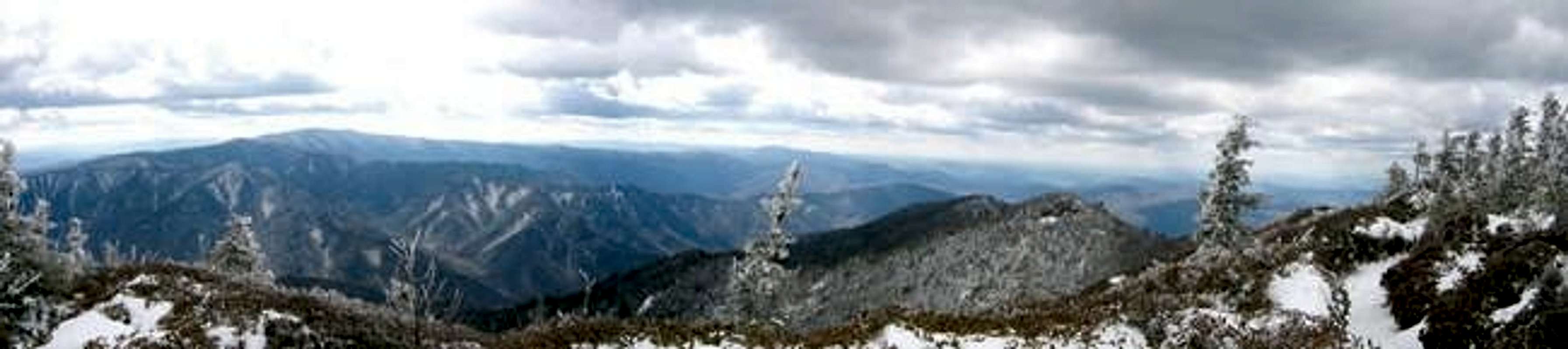
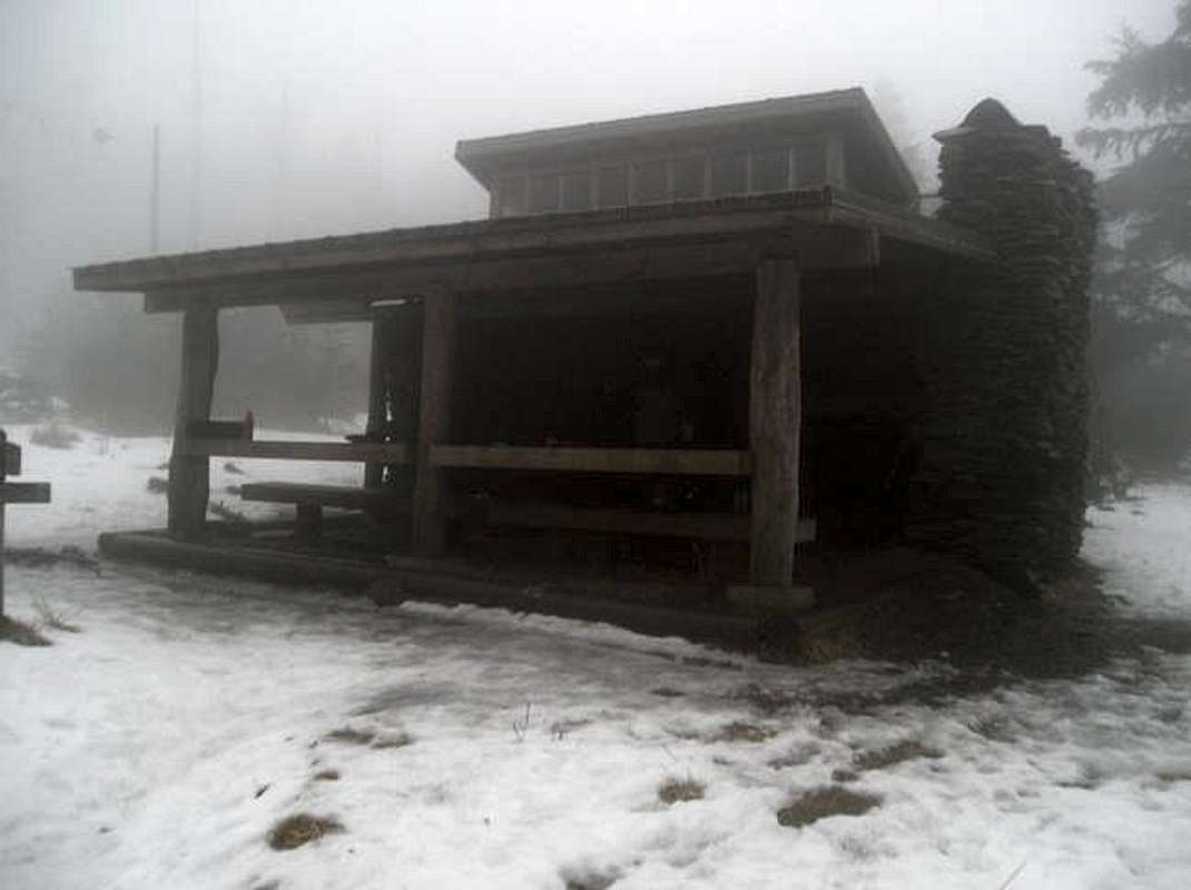
Winter Wonderland
All five trails servicing the summit of LeConte begin from various access points off US-441. US-441 is the only road that bisects the Great Smokies. It runs from Gatlinburg, Tennessee in the west to Cherokee, North Carolina in the east.
The Trillium Gap Trail begins at the Grotto Falls Parking Area off the Roaring Fork Motor Nature Trail. This trail gains over 3300 feet on its climb to the summit. 1.5 miles into the hike you reach scenic Grotto Falls. The trail climbs steadily and steeply. At 2.7 miles you gain the ridge at Trillium Gap, on the shoulder of Brushy Mountain, at an elevation of approx. 4700 feet. From here there are spectacular views of neighboring LeConte. This is about the half-way point. The trail continues another 3.6 miles and almost 2000 feet before you reach the summit buildings of LeConte.
Boulevard View
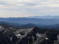
The Boulevard Trail begins from Newfound Gap parking area. This trail offers the least elevation gain by far of the five, only about 1100 feet. It is however the longest route to the summit and the numerous ups and downs along the trail make it fairly strenuous. From Newfound Gap you will follow the Appalachian Trail along the Tennessee/ North Carolina state line for the first 2.7 miles to the junction and official start of the Boulevard Trail. The Boulevard Trail then heads north into Tennessee following the steep-sided ridge which is the trails' namesake for 5.3 more miles to the LeConte Lodge. Just before the trail reaches the lodge it passes over the two main summits of Mt. Leconte - High Top and Cliff Top. High Top is the mountains true summit but views from both "Tops" are spectacular. The Boulevard Trail is the only trail that passes over the true summit of Mt. LeConte.

Alum Cave Bluff
Alum Cave Bluff Trail supports the bulk of traffic going to and from the summit of LeConte. Beginning also only about a mile north of Newfound Gap parking area the trail offers perhaps the most scenic route to the top of the mountain. The trail gains a little over 2500 feet from beginning to end. Departing the parking area the trail follows the ridge crossing a couple small streams. At 1.3 miles the trail passes beneath Arch Rock and at 2.0 miles you reach Inspiration Point where from a small rock outcrop there are magnificent views across to Little Duck Hawk Ridge. At 2.2 miles you reach the impressive Alum Cave Bluff area. Alum Cave Bluff is a 80 foot tall cliff face that overhangs the trail for about 150 yards. Most people that hike this trail turn around after viewing this landmark. From here the trail climbs steadily, and sometimes steeply, for another 3.3 miles to the LeConte Lodge with numerous beautiful views along the way.

Rainbow Falls
The Bullhead and Rainbow Falls Trails begin from the same parking area along Cherokee Orchard Road and are a popularly used together as a loop hike to the summit of LeConte, a round trip of about 12 miles (the trails are about identical in length). One note though - these trails are STEEP - only Bullhead is a suitable trail for descent. From the parking area to the summit is almost a 4000 foot climb. Rainbow Falls Trail reaches its namesake waterfall after about 2.4 miles. 3.4 miles and 2000 vertical feet later the Rainbow Falls Trail rejoins the Bullhead trail for the final 0.2 miles and 600 foot climb to the summit lodge. Bullhead Trail ascends more gradually with a few steep pitches along the way as opposed to the relentless uphill grind of the Rainbow Falls Trail. There are many great outlooks along the way, the best being from Bullhead itself. It joins the Rainbow Falls Trail at 5.8 miles and the summit at the 6 mile mark. For a scenic albeit demanding hike ascend via the Rainbow Falls Trail and descend via the Bullhead Trail, it's the best work out this mountain offers!
Take A Virtual Hike Up Mt. LeConte!!!
Follow along with me on a summer trip to the summit of LeConte via the Alum Cave Bluffs Trail by clicking HERE
Red Tape & Camping Info
If you plan on just making a day trip to Mt. LeConte there are no fees or permits required. Entry to the Great Smoky Mountains is free and so is trailhead parking.
However if you are planning on staying overnight in the backcountry you are required to pick up a free backcountry camping pass. You can get a pass at any ranger station or visitors center. You must also make reservations ahead of time for the backcountry campground or shelter you intend to use. The only campground/shelters in the LeConte vicinity are the LeConte Shelter, just below High Top, and the Icewater Spring Shelter just north of the Bouleverd Trail junction along the Appalachian Trail. For backcountry info call (865) 436-1297. To make backcountry reservations call (865) 436-1231.
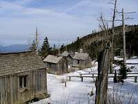
LeConte Lodge
The other option for an overnight trip is of course the LeConte Lodge. Reservations can be made by calling (865) 429-5704. For more info visit the LeConte Lodge site on the Links page for more info about the lodge than I could ever include here.
Just for your info pets are not allowed on backcountry trails within the park.
When To Climb & Mountain Conditions
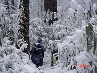
Conditions on Mt. LeConte vary widely depending on elevation. Hiking from its base to summit is the ecologic and climactic equivalent of a hike up the eastern seaboard. Pack accordingly, as a general rule you will loose about 5 degrees for every 1000 feet you climb but this can vary. It is not uncommon in the winter to have temps in Gatlinburg in the 50's and 60's while at the summit it is in the 20's or less!
The busy season in the Smokies generally lasts from May to early September with a brief period in mid October during leaf season. My season of choice is in the slower months between, after the leaves have fallen. During these months you will have clear, cisp days to hike and enjoy views uninhibited by haze or foliage.
To view what conditions currently look like visit the "LeConte WebCam" on the Links page.
To see what the weather has been like in the park over the last 24 hours visit the "Smoky Mountain Weather" site on the Links page.
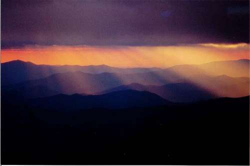 LeConte Sunset
Bears!
Bears are a major concern while overnighting in the park. They are rarely a threat to life or limb but can be a nuisance when food is not properly stored. Please visit the NPS page on bears for more info.
External Links
- South Beyond 6000 Peak List
At 6593' Mount LeConte is ranked 6th out of 40 in the "South Beyond 6000" peak bagging list. - Photo Journal of Mt. LeConte Trips
Photo Journal of Mt. LeConte Trips - LeConte Lodge
Any and all info you could want concerning the LeConte Lodge. - Hikes on Mt. Leconte
A page created by a man who has summited LeConte over 1000 times! - Mt. LeConte WebCam
WebCam view of Mt. LeConte from Gatlinburg. - Smoky Mountain Weather
Weather reports from the prevoius 24 hours for varoius points around the Smokies including Mt. LeConte. - Mount Leconte (10/30/2004)
DWhike's Adventures - Shameless self promotion...come visit my website for more pics of Mt. LeConte and other places that I have wandered off to in recent years...
dwhike - Sep 25, 2004 3:39 am - Hasn't voted
Untitled CommentThanks for the correction. Not sure why I didn't catch that.
jamesrodom - Sep 24, 2004 6:38 pm - Hasn't voted
Untitled CommentThe Alum Cave Bluff Trailhead is not at Newfound Gap, but rather at a parking area several miles northwest along Route 441.
dwhike - Sep 25, 2004 3:39 am - Hasn't voted
Untitled CommentThanks for the correction. Not sure why I didn't catch that.
Sarah Simon - Apr 3, 2009 6:40 pm - Voted 10/10
Alum Cave TrailHello, In responding to a forum post, I discovered the Alum Cave Trail route was not attached to this page. http://www.summitpost.org/route/168122/alum-cave-trail.html Cheers, Sarah
dwhike - Apr 4, 2009 11:54 pm - Hasn't voted
Re: Alum Cave TrailSarah, thanks for the heads up. Looks like the creator of the Alum Cave page attached it as a 'parent' of LeConte instead of a 'child.' I've made the corrections so now it should be a bit easier to find! Regards, Dan
CheesySciFi - Jul 15, 2010 2:52 pm - Voted 10/10
Update on Trillium Gap TrailA few days ago, the rangers told me that the Roaring Forks Motor Nature Trail is closed for now, which adds about 5 miles and 800 feet of elevation gain to the Trillium Gap Trail. The trail can still be accessed from the Rainbow Falls trailhead, but not the Grotto Falls parking lot.
dwhike - Jul 16, 2010 3:31 pm - Hasn't voted
Re: Update on Trillium Gap TrailThanks for the info I'll get it posted ASAP.
dwhike - Mar 15, 2011 9:13 pm - Hasn't voted
Re: Sierra Peaks SectionThanks for the heads up. Fixed.
HooKooDooKu - Apr 6, 2016 6:42 pm - Hasn't voted
Camping Permits are NOT FreeA few years ago, GSMNP changed the rules. Back country permits are now obtained from the website https://smokiespermits.nps.gov/index.cfm?BCPermitTypeID=1 and cost $4/person/day.