
|
|
Mountain/Rock |
|---|---|
|
|
39.98280°N / 105.685°W |
|
|
12640 ft / 3853 m |
|
|
Overview
Peak 12,640 (12,660 from some sources) is a spectacular peak in the Indian Peaks Wilderness just north of Devils Thumb and just to the south of Jasper Peak. The easiest route is only Class 2+, so it makes a nice alternate destination to the Thumb for those who are not technical climbers.
Roach’s Guidebook and other sources use the figure/name of Peak 12,660 which was obtained by interpolated contours, but recent LiDAR data show the peak closer to 12,640 feet and using LiDAR the peaks loses its ranked status.
The peak is a spectacular summit and has a huge alpine wall on its south side. If the rock is similar to that of Devils Thumb it should be good for technical climbing. In spite of the fact that this peak has no name and no marked elevation, it is one of the highest ranked peaks in the Indian Peaks Wilderness. It also has the distinction of being the highest ranked peak in the wilderness with out an official or a name in a guidebook.
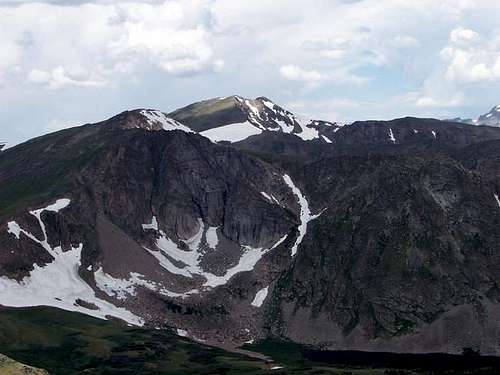 Peak 12,696 is the peak on the left and with the vertical face. Jasper Peak is the peak in the center of the photo.
Getting There
There are three commonly used trailheads for climbing Peak 12,695. Since I have only been to two, and hiked to Devils Thumb Pass from these two trailheads, check the link below for the Hessie Trailhead.
Front Range residents may want to come from the Hessie Trailhead and Devils Thumb Lake since it offers the shortest driving route from Denver and the rest of the Front Range.
HESSIE TRAILHEAD
You can also drive to the area of east of Rollins Pass from Eldora and hike to Rollins Pass from the Moffat Tunnel, but I am unfamiliar with that driving route as well.
ROLLINS PASS TRAILHEAD
Drive Highway 40, either north of Fraser, or south of Berthoud Pass, to just north of the main Winter Park Ski resort. Between mile markers 231 and 232, turn east on to the road marked for Corona/Rollins Pass (14 miles from Highway 40). This is County Road 80. Follow the main road to the trailhead at Rollins Pass. The road becomes Forest Road 149 after reaching the forest boundary. The road is rough in places, but cars can make it all the way to the trailhead when driven slowly and with great care.
DEVILS THUMB PARK/CABIN CREEK TRAILHEAD
Drive to the north end of Fraser on Highway 40, and to between mile markers 226 and 227. Turn east on to the road marked for County Road 8. Follow County Road 8 for 6.4 miles to the forest service boundary, at which point the road becomes Forest Road 128. Turn left and follow the road for 1.1 miles to a junction at which point you will turn right and drive for .3 miles to the end of the road and at a small dam. This is the trailhead. This road is also rough in places, but can be driven by a car if you go slowly and if care is taken.
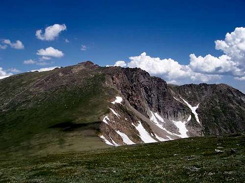
 Peak 12,695 is in the center of the photo.
Routes Overview
I have hiked to Devils Thumb Pass from Rollins Pass and from Devils Thumb Park, so these will be the routes discussed. Another route to Devils Thumb is from the east and the Hessie Trailhead. This is the shortest driving route to any of the trailheads for Front Range residents.
The route from Rollins Pass offers the shortest elevation gain, but since the route is entirely above timberline, it is more exposed to the elements. The road also opens later in the year and is often blocked by snow drifts into early July.
The route from Devils Thumb Park has more elevation gain, but is not difficult and the road is usually open earlier in the season. The trail also seems to see less hiking traffic.
Both routes meet at Devils Thumb Pass and then climb the south ridge of Peak 12,695 to the summit. There is some short class 2+ scrambling along the way.
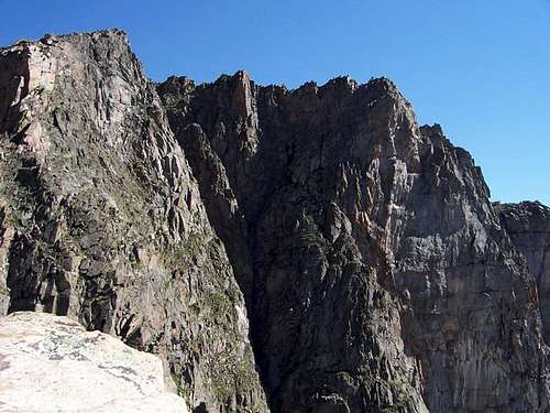 The huge south face of Peak 12,695.
Red Tape
There are no permits required for day hiking/climbing. A permit is required for camping within the Indian Peaks Wilderness between June 1 and Sept. 15. Permits are $5.00 and are available at the locations below:
Sulphur Ranger District
9 Ten Mile Drive
Granby, CO 80446
970-887-4100
Boulder Ranger District
2995 Baseline Road, Room 110
Boulder, CO 80303
303-444-6600
Estes Park Office
161 Second Street
Estes Park, C) 80517
970-586-3440
When To Climb
The normal hiking climbing season is July through September. The access roads are not open in winter. It would still be interesting to climb this peak in winter. If you did this, the shortest route in winter would likely be from the Devils Thumb Park area. It would likely take three days since the road is not open out of season. There may be some avalanche danger just west of Devils Thumb Pass as well.
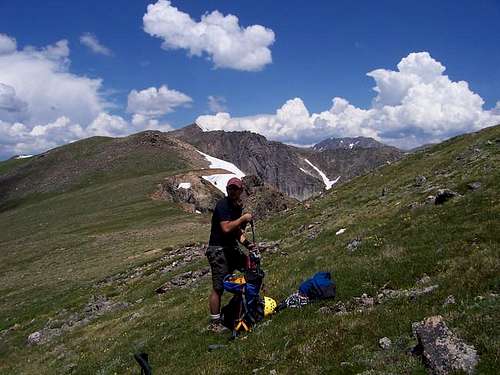
 Peak 12,695 in July.
Camping
There are many campsites along the roads to the Rollins Pass and Devils Park/Cabin Creek Trailheads. Rollins Pass itself can be used as a campsite, but it can be windy and exposed to the elements.
There aren’t that many great backcountry campsites along the two routes described to Devils Thumb Pass. If you have a strong tent, there are some flat places along between Rollins Pass and Devils Thumb Pass, but they are all near the ridge and above timberline. There are some campsites not far from the Devils Thumb Park trailhead and along that trail as well as some small campsites higher up and in the forest below the pass.
Mountain Conditions
For current trail and snow conditions, more information, and access issues contact:
Sulphur Ranger District
9 Ten Mile Drive
Granby, CO 80446
970-887-4100
PEAK 12,695 AREA MOUNTAIN WEATHER FORECAST
Below is the climate summary for nearby Berthoud Pass at 11,315 feet elevation. These are all averages, so expect more variation, but this will give you a good idea about the climate at higher elevations in the area. *National Weather Service Data 1950-1985.
| MONTH | HIGH | LOW | SNOW DEPTH | DAYS W/PRECIP |
| JAN | 21 | 1 | 42" | 19 |
| FEB | 24 | 2 | 52" | 16 |
| MAR | 29 | 6 | 63" | 20 |
| APR | 36 | 14 | 67" | 17 |
| MAY | 45 | 23 | 53" | 16 |
| JUN | 54 | 32 | 17" | 11 |
| JUL | 62 | 39 | 0 | 14 |
| AUG | 60 | 38 | 0 | 14 |
| SEP | 53 | 31 | 0 | 11 |
| OCT | 42 | 21 | 3" | 10 |
| NOV | 30 | 10 | 14" | 15 |
| DEC | 23 | 3 | 29" | 18 |