
-
 4657 Hits
-
 77.48% Score
-
 8 Votes
|
|
Mountain/Rock |
|---|---|
|
|
38.02040°N / 107.7636°W |
|
|
Ouray |
|
|
Hiking, Mountaineering |
|
|
Spring, Summer, Fall |
|
|
12980 ft / 3956 m |
|
|
Overview
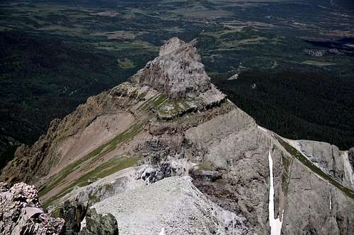 Reconnoiter Peak as seen from Mount RidgwayReconnoiter Peak is a beautiful summit in northern San Juans. It provides amazing views, solitude and mostly trail access with minimal scree terrain (until the last section to reach the summit). It is good to study a topo map prior attempting this peak. I went unprepared and scrambled on some loose rock with class 4/5 sections, but on the way down found class 2 trail!
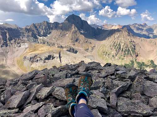 Mount Sneffels as seen from Reconnoiter Peak
Reconnoiter is only 20 feet short of being a 13er.
Colorado Rank: 650
Quad: Mount Sneffels
Parent Lineage: Mount Ridgway
Class: 2 (if you are on the easiest route)
I chose to hike Reconnoiter Peak as my only objective for the day. I have done all other ranked peaks in the Sneffels range, and enjoy returning to explore different approaches. I live close by and consider San Juans my home. Many peak baggers combine Reconnoiter Peak with Corbett Ridge, Angel Knob, Whitehouse Mountain, and Mount Ridgway. This is a big loop and does involve a lot more bushwhacking. I was happy with my route from Blaine Basin. There is a trail all the way to the basin below the saddle between Mount Ridgway and Reconnoiter Peak. The ascent into the saddle was on a grassy terrain - no scree!
Guide to the Colorado Mountains with Robert Ormes provides only a brief mention of Reconnoiter Peak. "From East Blaine Basin, attempts can be made up the eastern end of the cirque on Mount Ridgway (13,468'), known as S2 to the San Juan Mountaineers, or to the top of the ridge extending 0.7 mile northwest of Ridgway called Reconnointer Peak by climbers."
Getting There
Blue Lakes/Blaine Basin Trailhead: From Highway 62 between Ridgway and Telluride take Dallas Creek Road (right before Ralph Lauren's ranch). Drive 14 miles on well marked dirt road for 14 miles to the trailhead. The dirt road is in a good condition and passable even for passenger cars. It is well marked - follow signs for Blue Lakes Trailhead. There is camping at the trailhead.
The trailhead is very popular and it may be hard to find a parking or camping on busy summer days.
Route
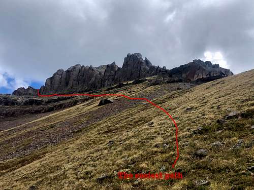 Reconnoiter Peak the easiest route
 Reconnoiter Peak
My single mountain trip was 12 miles and I have noticed that above mentioned combination with Corbett, Angel Know, Whitehouse, and Ridgway is only 11 miles, but my terrain was easier, mostly on a trail. The combination with other peaks will involve a lot of class 3 scrambling, loose scree etc.
Red Tape
There is no red tape. Hiking the Blaine Basin trail, camping, and exploring the area are free.
gThere are some prohibitions listed in Mount Sneffels Wilderness website: 1. Entering the area with more than 15 people per group and maximum combination of people and stock not to exceed 25 per group. 2. Camping within 100 feet of any lake. 3. Building a fire within 100 feet of any lake or trail and above treeline. 4. Storing equipment, personal property, or supplies for longer than 7 days.
When to Climb
Any time is good, but the road to Blue Lakes/Blaine Basin Trailhead is closed in the winter. Summer is the easiest. Early summer may be better since the upper slopes will be covered with snow and you can snow climb instead of scree hike.
Always check avalanche forecast if venturing out in the winter.
Camping
Free dispersed camping is available at the Blue Lake/Blaine Basin Trailhead. This area if very popular, so nice campsites may be taken on summer weekend. You can also backpack to Blaine Basin and camp in that area.