
-
 40912 Hits
-
 89.76% Score
-
 30 Votes
|
|
Mountain/Rock |
|---|---|
|
|
34.22780°N / 117.6231°W |
|
|
8693 ft / 2650 m |
|
|
Overview
This mountain is in San Bernardino County, and part of the San Gabriel Mountain Range. Ontario Peak is the smaller sister of Cucamonga Peak in the Cucamonga Wilderness. This mountain, with its many many summits can be seen easily from south Orange County on clear days as it towers to almost 8,700'. Adversely, from the summit one can see the inland empire (on a clear day), the San Jacintos, the San Bernardinos, the Santa Ana Moutnain range which lies directly south, and the majority of the other major peaks in the area, such as Baldy, telegraph, Cucamonga, etc. The mountain was indeed named after the nearby city of Ontario, which in turn was named after the Canadian Province of Ontario by natives George and William Chaffey. Of all the mountains in and around the San Antonio Canyon, such as Mt. Baldy (San Antonio), Cucamonga Peak, Telegraph, Thunder, Timber and Sugarloaf Peak, Ontario is the least often climbed due to the remoteness of the summit and the neccesity of some cross country hiking. Indeed, it is this remoteness that has offered a safe haven for the famed Bighorn Sheep to roam around somewhat peacefully. Chances are that if you spend enough time in the saddle between Bighorn Mountain and the summit of Ontario Peak, you may indeed spot one of these peculiar creatures. The most common route is from the Ontario Peak Trail, which begins at Icehouse Saddle at the end of Icehouse Canyon. The trail is pretty well maintained except towards the end where some crosscountry skills will be needed to find the "true" summit. There are no other standard routes up this steep and rocky mountain, however, the adventurous soul can attempt to climb the Northwest face as it has less chapparal vegetation. The majority of the climbs up Cherry Canyon, Falling Rock Canyon, North Fork and Kerkhoff Canyon include steep talus screes along with steep rock bands. Most of these possible routes entail class 4 climbing, so venture into this area with care.
 |  |  |  |  |
Getting There
 From Orange County: Take the 91 freeway to the 71 expressway (this is a little known shortcut), from here exit on highway 83 (or Euclid Avenue) and follow it north until it passes the cities of Chino, Ontario, and Upland. Ontario Peak will tower above as it skies directly in front of Euclid Avenue. Stay on the road as it turns into Mount Baldy Road. From here, pass the town of Mount Baldy and turn into the Icehouse Canyon Parking lot. Obtain a Forest Adventure Pass before parking your vehicle.
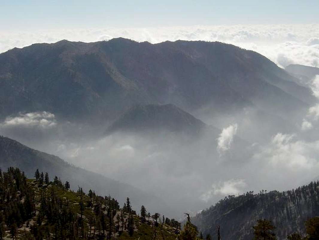
From Los Angeles County: Make your way to the 10 freeway as conveniently as possible and head East. Once in the Ontario/Upland region exit Euclid and head North. The same directions apply as from Orange County.
From San Diego County: Head northbound on Interstate 15 until it meets the 10. Here, go westbound on the 10 until Euclid Avenue appears. Exit and Head North. Same directions apply from here.
From the High Desert (Hesperia, Victorville): Take the 15 freeway southbound until it meets the 10, go westbound until you hit Euclid Ave. Go North. Same....
 |  |  |  |
Red Tape
Yes. You will need to obtain a Wilderness Permit as this area is in the vicinity of the Cucamonga wilderness. Wilderness Permits can be obtained at the Mount Baldy Visitor Center, which is in the town of Mount Baldy. The Visitor Center is directly across the street from the Mt. Baldy Lodge on the left hand side. Also, you will need a $5 Forest Adventure pass that can be obtained at the Visitor Center or at a littte store at the parking lot of Icehouse Canyon. Party sizes are limited to 12 people and open campfires are strictly prohibited.
 |  |  |  |
When To Climb
This mountain can be climbed any time of the year as its high elevation allows for cool weather during the summer months. During winter the mountain can have very deep snow packs, depending on how heavy winter can be. Ontario Peak Trail can be fun in winter for snowshoeing as there is limited exposure on the way to the summit. The best time to climb this mountain is in the fall, as temperatures are prime, although it can still get cold as its summit elevation is over 8,600'. Moreover, this is a seldom climbed mountain so even on weekends dont be surprised if your are the only soul you encounter after you proceed past the Icehouse Saddle. Avoid climbing this mountain during stormy weather as many hikers have gotten lost in this area. As mentioned before, the trail becomes difficult to follow after a certain point towards of the peak, so be aware that snowy whiteout conditions can further exacerbate this obstacle. Also, winter time temperatures can easily drop into the teens towards the summit so be aware of this and dress warmly if one decides to venture up here in stormy conditions.
Camping
Camping is allowed at Kelly Camp which is at 7840 feet elevation. This is right off the trail so it will be impossible to miss. Fees and permits are required, so if you plan to camp here make sure you check in with the Visitor Center in Baldy town.
Mountain Conditions
You can call the San Bernardino National Forest (909) 383-5588 for current weather condtions. Also, check the Mount Baldy Ski Area snow report as it is in the vicinity and roughly at the same elevation (Mt. Baldy ski area tops out at 8,600'). Checkout the website at www.mtbaldy.com and click on live weather for an upto date weather report.
jazamoo - May 29, 2006 5:13 am - Voted 10/10
"fake peak"from the Kelly-sign where it points to the Bighorn on the left and Ontario on the right, there's a high-point right before the "actual" Ontario Peak with a Summit Register on it! The (very wet) notebook inside is labelled as "fake peak"; Ontario Peak is the next peak over, topped by a loveli(er) pile of rocks.
MelbaToast - May 28, 2007 1:36 pm - Voted 10/10
Getting ThereYou can also get there from the 210 Foothill Fwy. You exit at Mountain Ave, Mt. Baldy and make your way to the Icehouse Canyon Lot.
tarol - Sep 20, 2008 11:50 pm - Voted 10/10
SBNF phone number is incorrectit's 909-382-2600