
|
|
Mountain/Rock |
|---|---|
|
|
44.77330°N / 72.5518°W |
|
|
Orleans |
|
|
Hiking |
|
|
Spring, Summer, Fall, Winter |
|
|
3360 ft / 1024 m |
|
|
Overview
Belvidere Mountain is located in the northern portion of the Green Mountains of Vermont. Situated in a less traveled part of the Green Mountain State, a hike to the summit assures a quiet and peaceful outing, in any time of season. This section of the Green Mountains is the least visited out of the 270 mile Long Trail that runs its’ length. The Long Trail is the most common route to the top, the mountain can also be ascended via the Forester's Trail that starts near the Asbestos Mines. Belvidere Mountain is prominent making the summit more rewarding. The Mountains' higher neighbors are Jay Peak 10.5 miles to the north and Sterling Mountain 16 miles to the south.
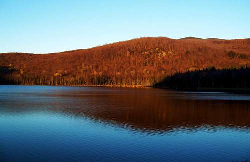 Sunset on Belvidere Mountain
The summit of Belvidere Mountain is occupied by a 50 foot tall Fire Tower that was first built in the early 1900’s and recently rebuilt in the early 1990’s. The summit is partially wooded and without the Fire Tower it has excellent views to the East. Though from the top of the Fire Tower you will have spectacular views of the Green Mountains, the Cold Hollow Mountains, several Canadian Mountains and if it’s clear enough, Mount Washington in the Presidential Range of New Hampshire, 71 miles away.
In Vermont, Asbestos was first mined on the eastern slopes of Belvidere Mountain in 1899. These mines were operated as recently as 1993 and from the summit the scar of past mining can be seen. More information about the past mining activities on Belvidere Mountain, can be found here. Information on the geology of this mountain can be found here.
Getting There
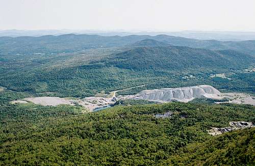 View East towards the Presidentials. An Inactive Asbestos Mine Below
From Burlington, VT (47 miles) :
From Burlington, get on to route 15 west and head towards Essex. Continue for 28 miles to Jeffersonville, VT. In Jeffersonville take route 109 north and go past Belvidere Center until you reach the intersection with 118. At the intersection go south on 118 and you will pass Belvidere pond to your left and reach the trailhead for the Long Trail at 2 miles from the intersection. Park here, at this dirt lot.
Route Description

The Fire Tower on the summit
Long Trail north to Forester’s Trail to Belvidere Mountain Summit. This is a map of the route overview.
Round Trip Distance : 5.6 mi
Elevation Gain : 2000 ft
From the Long Trail parking lot to the summit of Belvidere Mountain it is 2.8 miles one way and 2000 vertical feet of gain. From the parking lot; head north and follow the white blazed Long Trail through the deciduous forest. The trail first follows an old road and is very wide. Soon the trail crosses a small stream and you then follow it to your left. Continue up the trail it soon becomes steeper but nothing difficult. After the steep sections the trail levels out a little bit in a swamp like area where mud is avoided by crossing logs. After 2.6 miles on the Long Trail you will reach the spur trail to the summit called the Forester’s Trail and from here it is 0.2 mile to the summit and Fire Tower.
When To Climb

Snow & Moss in October
The best time of the year to do this hike is between the early summer and late fall. Spring time conditions usually present mud therefore hikers are urged to stay off trails to help prevent trail erosion. Because of the melting snow, from April 15 to Memorial Day, the Green Mountain Club wants hikers to stay off trails.
During the summer you might want to bring bug repellent, as mosquitoes and black flies can be quite bad. In the fall, there is usually some excellent foliage and winter temperatures are typically well below zero with wind chill so dress appropriately. This trail is not regularly used in the winter time so if attempting a winter ascent make sure you know where you’re going.
Camping

Looking north towards Jay Peak and Canada
If you are a Long Trail through hiker Belvidere Mountain is located between two shelters. There is the Spruce Ledge Camp that is located south of Route 118. There is also the Tilloston Camp that is located north of Belvidere Mountain. The shelters and distances for the Long Trail can be found here.
If you are looking to hike Belvidere Mountain as a day hike and you’re looking for a campground, I would suggest camping at Elmore State Park, which has 45 sites and is located on Elmore Lake. The campground also has easy access to hiking trails that go to the top of Elmore Mountain, which has also has a fire tower on it. More information on the Vermont State Parks and their campgrounds can be found here.
Red Tape & USGS Quads

Mount Mansfield and Sterling
No permits are required. The lower portions of the Long Trail cross private property; please respect it. The upper parts of Belvidere Mountain are located in the Green Mountain National Forest. The Green Mountain Club urges hikers to stay off trails from April 15 to Memorial Day to help prevent trail erosion.
USGS Quads
- Hazens Notch (1:24k)
- Eden (1:24k)
Mountain Conditions
The Green Mountain National Forest website can be found here
A predicted forecast for the area can be found here.
Local weather for Eden, VT can be found here.
radarlove9 - Feb 22, 2010 1:02 pm - Hasn't voted
Skiing?anyone do any backcountry skiing on Belvedere? I might go for it but want to know which trails are best.