
-
 3690 Hits
-
 79.78% Score
-
 11 Votes
|
|
Mountain/Rock |
|---|---|
|
|
34.95560°N / 33.17777°E |
|
|
Hiking |
|
|
Spring, Summer, Fall, Winter |
|
|
3635 ft / 1108 m |
|
|
Overview
 The long ridge of Moutti tou Klimatou The long ridge of Moutti tou Klimatou |
In the east of the Troodos Mountain Range pretty much in the geographical centre of the island of Cyprus you can find the historic Macheiras Monastery, one of the major tourist attractions in the southern part of the island. Founded in the 12th century, the monastery resembles a castle with a multitude of orthodox churches of all sizes. It is also an excellent trailhead for interesting hikes in the area, mostly the western north ridge of Kionia in the south and the traverse of the Macheiras Valley and the ascent of Moutti tou Klimatou in its north.
The mountain (Mουττι του Kλίματου in Greek) is one of the summits of a long limestone ridge which is the boundary of the Troodos Rangen before it drops into the large plain of Güzelyurt. In the latter runs the boundary between the Turkish northern part of the island and the Greek southern one. Consequently the area is considered of high strategic importance with lookouts and military installations everywhere on the mountaintops. Moreover, the area saw severe fighting during the civil war which led to the separation of the island. Patriotism still runs very high with statues and a nationalist museum attached to the monastery.
 |  |  |
In recent years, however, the tourism industry drew almost all inhabitants of the Macheiras area to the cities along the south coast of Cyprus so that villages have been virtually abandoned. To the north and south of Moutti tou Klimatou you can find two of these villages, Lazanias in the south (still inhabited during the weekends) and Fikardou, which has become a museum village in order to draw back some locals by attracting tourist interest. Usually tourists go there by coach but there is a much better and more interesting route to follow.
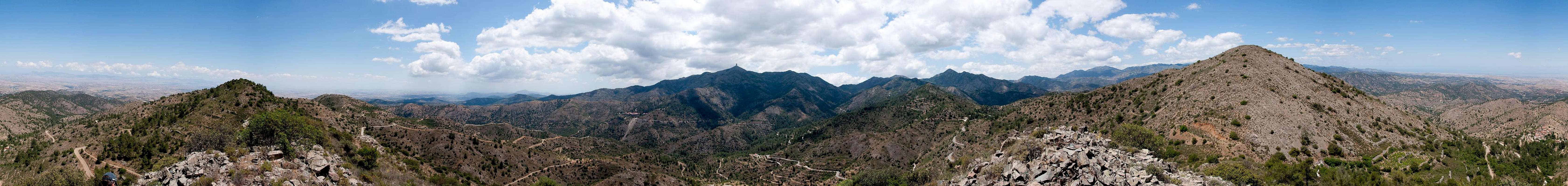
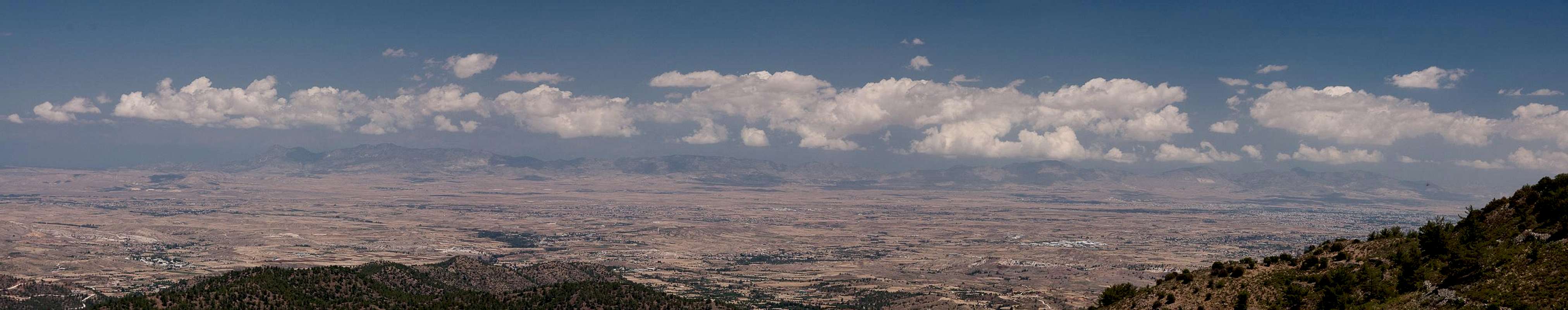
From Macheiras Monastery an old mule path leads into Macheiras Valley. It connects the monastery with Lazanias on the opposite side of the valley, from where it crosses a saddle to reach Fikardou. From the saddle an unmarked trailless and steep ascent leads to the summit of Moutti tou Klimatou. The underlying rock is britle limestone and the ascent can be a little tricky.In addition thorny bushes block part of the ridge so that orientation also becomes challenging. From the summit, however, you have good views towards the surrounding mountains and across the plain of Güzelyurt towards the Kyrenia Range in the Turkish part of the island.
360° Summit Panorama
  |
Getting There
 Macheiras (Kionia), Stavropefkos and Papoutsa, the main mountains of eastern Troodos
You can reach the Greek (southern) part of Cyprus from any major airport in Europe. The island has two international airports at Larnaka in the east and Pafos in the south-west. Both airports are connected by a motorway.
- From Larnaka take the motorway in direction Pafos
- Take the exit 13 / Skarinou.
- Drive through Lefkara and Vavatsinia
- Here signs will direct you to the Kionia Picnic Site and Macheiras Monastery
- Pass the Monastery and follow the signs to Lazanias and / or Fikardou
Red Tape
 Papillo machaon
As you can imagine, on a divided island there is quite some red tape. Generally, along the coasts and in the mountain ranges only the usual restrictions apply. In the natural parks, keep to the trails, leave animals and plants in place and – most importantly - don't start fires anywhere. Fire hazard is high throughout spring summer and early autumn and some of the oldest forests on Troodos have been devastated by careless fires.
Moreover, military installations have to be handled with care. They are guarded with barbed wire fences and taking photographs is restricted in their vicinity. Nervousness still runs pretty high. Many mountaintops carry lookouts or radar installations and even if they don't they can be visited by military patrols.
Accommodation
 |
Accommodation of all kinds is easy to find along the coasts of the island. You can book hotels and apartments from any travel office. Moreover, a lot of British expatriates are living on the island part time. You can get lucky to book one of their winter homes in summer.
Near Macheiras (mountain and monastery) or Moutti tou Klimatou little accommodation can be found. The closest town is Lefkara, where you'll surely be able to find inns and hotels. However, more likely you will stay at the south coast on the strip between the cities of Lemessos and Larnaka.
Weather Conditions
Maps & Books
Maps
I must admit that I didn't find any decent maps of the island, maybe caused by the military nervousness mentioned above. I have used the following street map:
- Cyprus / Chipre / Zypern
1:200 000
Freytag & Berndt
ISBN: 978-3-7079-0478-9
Books
Here the situation is different. An excellent guidebook is available from Rother Verlag, both in German and English. It covers the whole island in 50 daytours.
- Zypern (Süd & Nord) / Cyprus (South & North)
Rolf Goetz
Rother Wanderführer / Rother Walking Guide
Rother Verlag
ISBN (German): 978-3-7633-4271-6
ISBN (English): 978-3-7633-4814-5