
-
 3450 Hits
-
 77.48% Score
-
 8 Votes
|
|
Route |
|---|---|
|
|
58.41819°N / 134.59003°W |
|
|
Download GPX » View Route on Map |
|
|
Mountaineering |
|
|
Summer, Fall, Winter |
|
|
One to two days |
|
|
Class 4 |
|
|
Overview
Update 11/13/18 - Changed glacier crossing because previous route melted away.
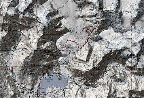
Mt. Weather is a 20.7 mile round trip climb to a technically challenging peak almost 6,000' tall that stands center stage in the Mendenhall Glacier.The Standard Route starts on the West Glacier trail, crosses the Mendenhall Glacier, and climbs the prominent ridge on climbers Right. This route requires glacier travel experience and knowledge of crevasse rescue. There are no trails to follow after deviating off from the West Glacier Trail so route finding is crucial.

Getting There
To access the standard route up to Wrather, you must first find the West Glacier Trail. From Downtown Juneau, take Egan Drive North. Make a right on Mendenhall Loop Road. After 2.2 miles turn left to stay on Mendenhall Loop Road. Turn right on Montana Creek Way. Continue on Montana Creek Road past Skaters Cabin. The road will dead end at the West Glacier Trail trailhead.

Route Description
The Mt. Wrather Standard Route is done by taking the West Glacier Trail. From the parking lot, take the West Glacier Trail for 3.2 miles until it reaches a rocky outcropping. This is past both the spurs to the location of the old ice caves. From that point follow a faint user trail downhill and generally to the North-East and down to the glacier. From here, you are immediately greeted with some large crevasses. Follow the ridges of ice until a large flat area. Head almost due North up a ramp in the center of the galcier, then turn and cross the glacier to the far side. Hug the glaciers edge up over some scrambling bits and steep snow and ice. you will bounce between the ice and rock a few times before reaching suicide basin.

The entrance and exit from the basin are extremely broken and patient route finding must be taken.

After crossing Suicide Basin, you are now walking next to the base of Mt. Wrather. Continue along the base of the mountain on the glacier until the steep rocks on climbers right become passable. Head up staying to climbers right of the prominent rock chunk sticking out (glacier Grub Tower). The incline is steep, but free of objective hazards here.

Once the top of the incline is reached, stay right of the main glacier and generally follow the prominent ridge all the way to the summit.


See attached .gpx route for a exact description and or check out the Juneau Hikes and Summits CalTopo page.
Essential Gear
Crampons and ice axe are crucial. Other climbing gear can be brought for crevasse rescue such as, rappel device, ice screws, and a few carabiners. In addition dress appropriately. Mountaineering boots or stiff waterproof boots are necessary and gators help keep your socks dry. Having a SPOT or InReach is a great idea. Bring extra dry/warm stuff.
External Links