
-
 8245 Hits
-
 72.84% Score
-
 3 Votes
|
|
Mountain/Rock |
|---|---|
|
|
58.48964°N / 134.4832°W |
|
|
Download GPX » View Route on Map |
|
|
Juneau |
|
|
Mountaineering |
|
|
Summer |
|
|
5968 ft / 1819 m |
|
|
Overview
Update 11/13/18 - Changed glacier crossing because previous route melted away.
Mt. Wrather is a 20.7 mile round trip climb to a technically challenging peak almost 6,000' tall that stands center stage in the Mendenhall Glacier. While the glacier soaks up much of the attention, to the right, the bold Mount Bullard obstructs the view of the monster known as The Nugget Towers. Left of the glacier the infamous Mendenhall Towers raise proudly and the jagged Stroller White Mountain continue the impressive skyline. Stroller White is situated next to McGinnis Mountain.

This mountain requires crossing the Mendenhall glacier so experience traveling on glaciers is extremely important. There also is no trail, so route finding is paramount.
Getting There
From Downtown Juneau, take Egan Drive North. Make a right on Mendenhall Loop Road. After 2.2 miles turn left to stay on Mendenhall Loop Road. Turn right on Montana Creek Way. Continue on Montana Creek Road past Skaters Cabin. The road will dead end at the West Glacier Trail trailhead.
Route
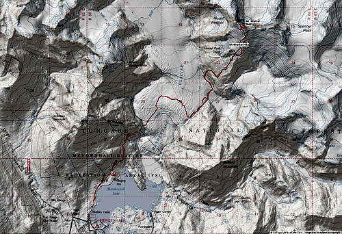
The Mt. Wrather Standard Route is typically done by taking the West Glacier Trail. From the parking lot, take the West Glacier Trail for 3.2 miles until it reaches a rocky outcropping. From that point follow a faint user trail downhill and generally to the North-East and down to the glacier. From here, head almost due North up a ramp in the center of the galcier, then turn and cross the glacier to the far side and hug the glaciers edge into suicide basin. The entrance and exit from the basin are extremely broken and patient route finding must be taken. After crossing Suicide Basin, you are now walking next to the base of Mt. Wrather. Continue along the base of the mountain on the glacier until the steep rocks on climbers right become passable. Head up staying to climbers right of the prominent rock chunk sticking out (glacier Grub Tower). Stay right of the main glacier and generally follow the ridge all the way to the summit.
See the route page for more details and for the map and Garmin .gpx files.

Red Tape
There is no red tape here, so please use LNT principles.
When to Climb
Mid-June through mid-September is the normal hiking season. With easy access, winter ascents would be reasonable as well, though there will be avalanche danger on the highest slopes.
June can be a really nice time to climb since it’s the sunniest summer month, though there tends to be more snow around. July is excellent too while August and September are wetter and cloudier. Fall and winter tend to be quite wet.
Winters are much milder here than in interior Alaska.

Camping
Backcountry Camping
Permits are not needed to camp in the Tongass National Forest.
