
|
|
Route |
|---|---|
|
|
42.47938°N / 13.56065°E |
|
|
Trad Climbing |
|
|
Summer |
|
|
A long day |
|
|
AD, IV a p. IV+ UIAA |
|
|
Overview
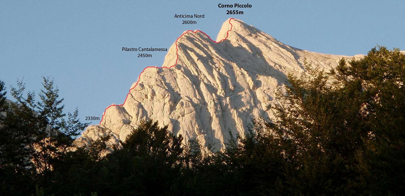
Looking to Corno Piccolo from north, the beautiful rocky ridge descending from the summit toward east seems like a Dragon's back.This beautiful ridge separates the east face from the north face, offering wonderful views all around, with aerial sights on Vallone delle Cornacchie and on Prati di Tivo.
Climbing over the Dragon's back is not hard (max IV/IV+), but the route is very long, and if you aren't used to climb on exposed rocks of II/III unroped, it can take to you many hours.
Keep attention to the weather conditions: a thunderstorm over the ridge can be very dangerous!
North-east ridge was first climbed by Enrico Jannetta and Aldo Bonacossa in 1923. In march 1957, Luigi Barbuscia and Sergio Lucchesi did the first winter climb.
Difficulty: III/IV with a passage of IV+ UIAA
Lenght: 660m (350m of elevation gain)
Altitude: 2330m-2655m
Rock quality: Excellent
Best season to climb: since early june to late september
 |
|---|
Approach
 Click to enlarge
From Madonnina, nearby the arrival of the Prati di Tivo chairlift (2012m), climb up the trail nr. 3 towards Passo delle Scalette and Franchetti Hut. When you meet a junction (about 2070m), take the trail on the right (Sentiero Ventricini) and follow it until you come under the first cliff, where the route starts.
Climb up the steep meadows, overcoming a rocky belt, until you arrive to the terrace exposed on Vallone delle Cornacchie. Here a big cairn signs the start of the route (50min from Madonnina).
When the chairlift is closed (or if you want to start before it starts its runs), from Prati di Tivo main square you can drive until Sella di Cima Alta, following a road on the left (3,5Km from the square): from there (1650m), walk the trail rising up the wide and scenic Arapietra ridge, until you reach the chairlift arrival (about 1h)
Route Description
 Topo of the route: click to enlarge
The North-east ridge route runs the long crest descending from Corno Piccolo main summit, passing by Anticima Nord -North secondary summit- and Spallone Nord -North Shoulder- recently renamed Cantalamessa Pillar, in honour of the strong climber Tiziano Cantalamessa (1956-1999).
The route is often climbed. Most of the difficulties are in the first 3 pitches (III and IV UIAA, pp of IV+), then the route becomes easier (II, III, long stretches where you can walk) but it remains often very exposed: less experienced climbers could feel the need to climb these pitches roped. So, the time of the ascent can varies very much: since 2h (if you climb the whole route unroped), to 8h if you want to climb all the pitches roped...
Belays are all equipped or you can easy do it on emerging rocks. Consider the possible need of integrate the belay with further gears.
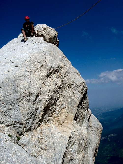
Pitch 1: enter in the couloir passing by a ramp, then climb up in the couloir until it becomes narrower: now you can climb directly the chimney (IV+) or avoid it on the right (maybe easier?) then traversing on the left where you arrive on the top. At the exit of the chimney, there's a good belay on bolts (50m, III/IV a p. IV+, pitons and tunnels)
From the belay, climb the easy but exposed ridge to a big terrace in front of the second cliff: belay on a big tunnel (20m, you can join this part with the next pitch...)
Pitch 2: climb up a chimney on the right (IV-, tunnels for protection), then bear on the left and climb up a slab (III+) until you reach the belay on a narrow terrace (40m, IV-, tunnels)
Pitch 3: traverse 10m on the left climb up a ramp on the right, until you reach the summit of the ridge. Belay on rock (30m, III)
From there, easily to the summit of Pilastro Cantalamessa (2450m)
 The start of the route
 Pitch 1
 Passing on the right
 Pitch 2: belay
These first three pitches, usually, are climbed roped: from there you can choose, on the basis of your skill and experience, if you can proceed unroped or not.
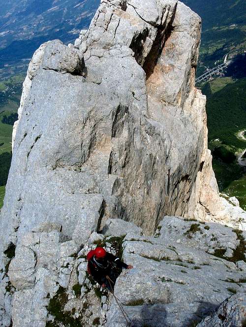
From the summit of Cantalamessa Pillar, continue climbing and walkin, facing an easy (II) but very exposed stretch of ridge (spectacular!)
Passed these narrow part of the crest, you have to climb the ridge leading to the Anticima Nord: the first 100/150m are exposed and with some demanding passages (III): you can find some pitons and two good belays on big tunnels if you want climb with rope.
After this relatively demanding part, the route becomes easier: climb and scramble (200m) on the north side of the ridge, until you arrive to the summit of Anticima Nord (2600m): from there you can descend (I, about 30m) or rappel to a col, overlooking the east face: from there starts the part of the ridge leading to the Corno Piccolo summit.
From the col, climb some easy slabs (70m, I UIAA), a bit on the right, then take a narrow couloir on the right (30m, II). After the couloir, climb the easy slabs (50m, I/I+) until you reach the summit of Corno Piccolo (2655m)
 |
 |
|---|
Descent
There are many possibility to descend from Corno Piccolo:
- by Via Ferrata Danesi: it’s a medium difficult Via Ferrata, with some stretches not equipped and passages of climbing of I-II UIAA. The Via Ferrata leads, in about 40min, to Vallone dei Ginepri, few meters above the exit of normal route from south. From there, to reach the chairlift arrival are needed about 1h 30min (from the summit about 2h 10min).
- by Corno Piccolo normal route from south: it’s a trail for expert hikers, with some short passages of I/II UIAA; it’s the easiest route to descend from Corno Piccolo (about 40min to Vallone dei Ginepri, about 2h 30min to chairlift arrival).
- by Corno Piccolo normal route from north: not marked, this route follows an easy couloir (I/II UIAA) placed immediately on east of Canalone Sivitilli. Usually you can find snow until july. This route leads to Sentiero Ventricini, in the stretch under Prima Spalla. It’s not so easy to find the start of the couloir from the top...
 Toward Anticima Nord
Essential Gear

- some narrow slings (dyneema) and cords for the several tunnels
- some friends medium-small size and nuts
- some pitons
- two 60m ropes are advised
Guides, Maps, External Links

L. Grazzini, P. Abbate, “Gran Sasso d’Italia”, Cai-Tci, 1992
S. Ardito, “A piedi sul Gran Sasso”, Iter, 1992
S. Ardito, “A Piedi in Abruzzo” vol. 1, Iter, 1996
A. Alesi, M. Calibani, A. Palermi, “Gran Sasso – Le più belle escursioni”, SER, 1996
You can find a very good report of North-east ridge route on L'Appennino, Inverno-Primavera 2003, magazine of Cai of Rome
Best map:
“Gran Sasso d’Italia. La carta dei sentieri”, edited by Cai-L’Aquila (scale 1:25.000)
Other route descriptions (in italian):
Enea Fiorentini web site (very accurated!)
Appennininik.com
Monte Geologo
Gulliver
Weather conditions:
Meteo bulletin Meteomont: Abruzian Apennines
Webcam:
Corno Piccolo north side from Prati di Tivo (on the right, Prima Spalla NE face)