
|
|
Route |
|---|---|
|
|
33.29250°N / 116.4303°W |
|
|
Hiking |
|
|
Winter |
|
|
Most of a day |
|
|
Class 3 |
|
|
Mostly class 2 with a few easy class 3 moves |
|
|
Overview
The North Ridge provides another route to the summit of Indianhead. It's definitely a good option if Palm Canyon is inaccessible for any reason.
I haven't climbed the established routes from Palm Canyon. But I think this route may be easier. It is shorter, especially if you have a high-clearance 4WD or AWD vehicle to reach the 4WD parking spot.
From 4WD parking, it is about 2.5 miles one-way to the summit, with nearly 3200' of elevation gain.
Here are some trip reports on Peakbagger.com that have GPX files you can download:
Thanks to Shano, who originally wrote up this route, and provided me a way to finally bag Indianhead. He called it "Henderson Canyon", but I'm going to change it to North Ridge.
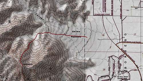
Approach
From Christmas Circle in Borrego Springs, Head north on Borrego Springs Rd (this is called Santa Rosa Drive on the 7.5' topo) for about 3.3 miles.
At this point, the paved road will dogleg sharply to the right (east). Turn left (west) on a dirt road that leads up toward Galleta Meadows.
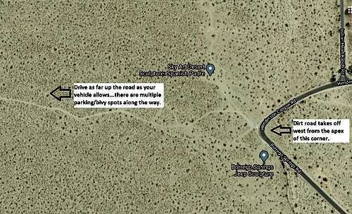
Drive as far west as your vehicle will tolerate. The road continues farther west than shown on the old 7.5' topo map. There will likely be some campers along the first part of the road, fewer as you continue up and the road gets more bumpy.
The 4WD parking at the end of the road is at N 33.30372, W 116.40060.
I recommend setting a GPS waypoint at your vehicle. The end of the road is in a low spot. I fortunately had a waypoint to guide me to my vehicle parked there. Because I couldn't see it until I was nearly back to it!
Route Description
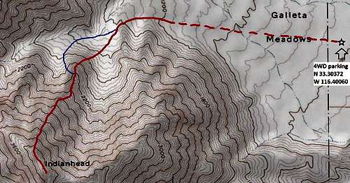
On the map above, my route is in red. The blue alternative near the bottom of the ridge is reportedly easier.
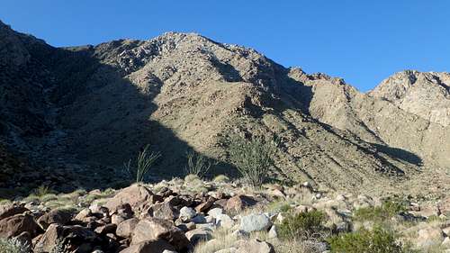
From your parking spot, proceed west up toward Henderson Canyon. Eventually curving left to enter the drainage on the north side of Indianhead. As the peak comes into view, the large ridge that is the route will be plainly visible.
The toe of this ridge is at N 33.3029, W 116.42517. Gain the ridge and follow it up.
I went more or less straight to the ridge from the spot where I took the above photo. However, it might be easier to approach the ridge by curving around to the right. See the route map for my route (red), and the suggested alternative for starting the ridge (blue).
While almost always steep--and sometimes very steep--the footing is quite good. The ridge hosts grasses, so it is not the loose scree-fest I feared when I tackled it. You may need to zig-zag around a bit to find the easiest passage, especially as you get higher on the ridge. If you do this, the ridge goes mostly at class 2, with the rare easy class 3 move at small rock bands. I am a poor scrambler/climber, but I had no problem with any of the easy scrambling moves on this route.
Eventually, there are very large boulders on the ridge crest. Some people might elect to scramble/climb over, around, or through them. I veered to my right and was able to continue at class 2, with the rare easy class 3 move.
Persevere up, and eventually you will top out at the summit ridge, northwest of the summit. The traverse from there to the summit is easy.
Essential Gear
A pair of trekking poles will be very helpful on this steep ridge.
More Information
The area is known for the metal sculptures scattered around the desert. These are located on private property currently owned by the Under the Sun Foundation. click for Foundation website
Another resource for information about the area is the Anza-Borrego Foundation: click for ABF website