
-
 8368 Hits
-
 85.87% Score
-
 21 Votes
|
|
Mountain/Rock |
|---|---|
|
|
46.95053°N / 10.30960°E |
|
|
Hiking |
|
|
Spring, Summer, Fall, Winter |
|
|
9396 ft / 2864 m |
|
|
Overview
 Palinkopf and Piz Crappa Grischa Palinkopf and Piz Crappa Grischa |
It might be disputable whether a mountain like Palinkopf (also Pauliner Kopf) belongs on SP and believe me, before submitting I meditated a lot about this question. What finally decided me was a look at the old guidebook I have, which was issued by the German and Austrian Alpine Clubs in 1982, roughly 25 years ago. Today you wouldn’t be able to recognize the area from the pictures in the guidebook. Man has wrought so many changes and - believe me - they are not for the better. Palinkopf is an especially nasty exhibit.
But let’s start with the facts.
In a pocket west of the Inn River you can find the Swiss exclave Samnaun. Duty free zone for the better part of the last 150 years, Samnaun has a long history of tourism. On three sides – the ones where it is most easily accessible – it is surrounded by Austrian states (Tirol and Vorarlberg) and its connection with the main country is via a very narrow mountain road or across the high passes to the village’s south. Its location right between many groups of the eastern Alps makes it a interesting lookout platform and Alp Trida, the huge alpine pasture to the village’s north is of particular interest. The Alp is surrounded by a circle of mountains of varying aspects: hill-like in the west and east but vertical and rocky in the north. A cable-car serves Alp Trida from Samnaun and you can spare a lot of time by starting from its top station. Several big hikes can be started here as well as the climbs of some of the more difficult northern mountains.
This is as much as you’ll find in the guidebooks. But there is a whole lot more that can be told.
The borderline ridge, which separates the exclave from the Paznaun Valley in Vorarlberg consists of those aforementioned hill-like mountains. Their names? Palinkopf (2864m), Salaaser Kopf (2700m) and Greitspitz (2870m). To both of its sides there are huge alpine pastures, not too steep but also not too shallow. In short: the ideal setting for ski runs. Not any ski runs – here you find the ski circuit of Ischgl / Samnaun. Endless numbers of ski-lifts mar the landscape. Skiers can’t be trusted to get down the slopes on their own so that highway-size runs have been dug out of the sides of the mountains. Naturally landslides and avalanches have taken their toll so that everywhere protective barriers have been put up. In short the area doesn’t look like an alpine meadow anymore. You are reminded of a quarry pit!
 Palinkopf S Palinkopf S |  Palinkopf NE Palinkopf NE |  Palinkopf SE Palinkopf SE |
Palinkopf has a special place in this madness. Three – yes that’s 3 – ski lifts serve its summit and both to the east and west one of those ski highways has been cut out of the mountain. The hiking trails – still described in detail in the guidebooks - have vanished underneath the construction and on a fine summer day you rather find cars of all sizes up there than hikers. In our case there were two tank trucks, filling one of the ski lift engine tanks for the winter. Also, at almost all times construction of new runs or mending of the old ones is going on up there. Only fools like us venture out into this madness.
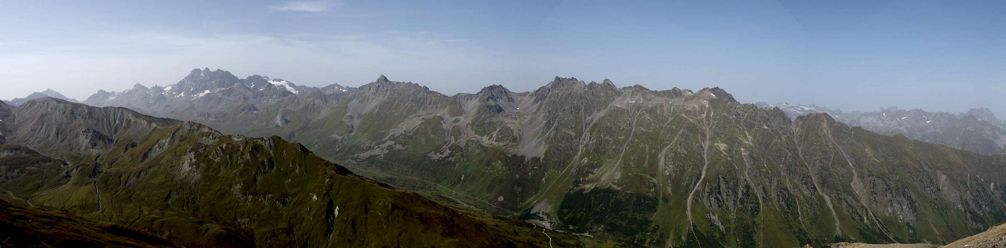
Which is one of the reasons for this page: to warn you against disappointments. Though Palinkopf has a beautiful panorama – mainly towards the Silvretta Group in the west and the unspoilt southern Samnaun Group in the south – climbing to its summit is definitely no fun. Be warned!
On the other hand research has shown that the depopulation of the alpine valleys, which can be observed in all regions of the Alps, can only be contained by making use of tourism. And the only profitable tourism is ski-tourism. Be prepared to find more regions moving in the same direction. Some already have but afaIk none as far as Ischgl / Samnaun.
Panoramic View
  |
Getting There
 |
Naturally you can start a climb of Palinkopf both from Ischgl and Samnaun but the fun involved with climbing from Ischgl must be minimal. There still is a surprisingly picturesque route from Samnaun through Val Musauna to Zeblasjoch, a saddle which separates the northern Samnaun main ridge from the Muttler Group in the south. Along this route only the last half hour exposes you to the ski madness around the mountain.
From Austria
- Take B180 from Landeck to Pfunds
- At Pfunds switch to the mountain road to Spiss and Samnaun
From Switzerland
- Take B27 from St. Moritz through Engadin.
- At Martina stay on the road to Vinadi, where the mountain road to Samnanun turns off.
From Italy
- Take SS38 and SS 40 from Bozen / Bolzano to Reschenpass / Passo di Resia
- In Austria take B180 through Nauders to Pfunds
- At Pfunds switch to the mountain road to Spiss and Samnaun
Red Tape
 |
You are in the duty free exclave of Samnaun. While you can easily buy all kinds of things toll free, smuggling has always been a problem in the area. Therefore be prepared to get your car checked by Austrian customs officers when leaving the exclave.
Accommodation
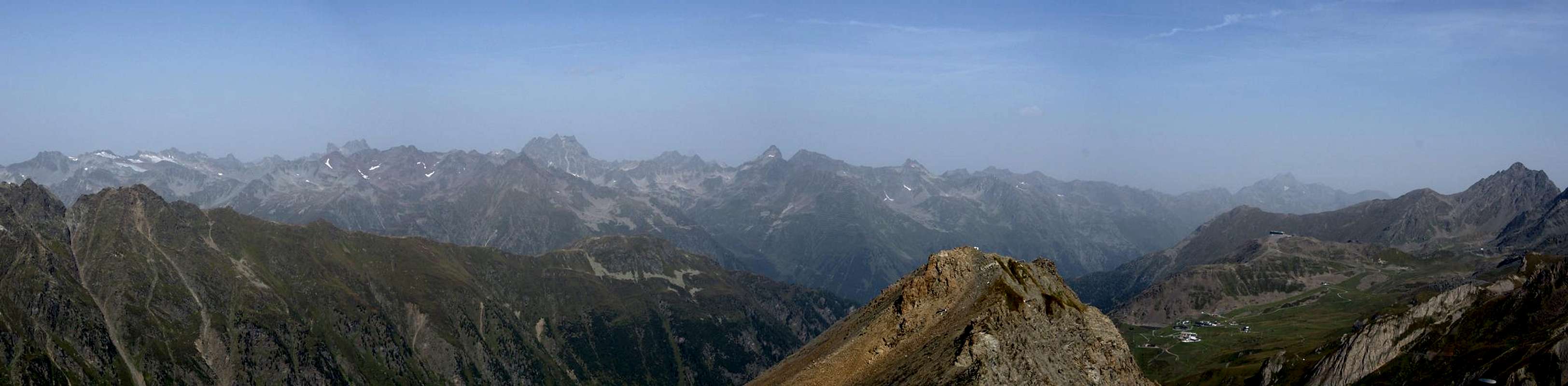
 Palinkopf and Piz Crappa Grischa seen from Zeblasjoch
Weather Conditions
Maps & Books
Maps
- Landeck-Nauders-Samnaungruppe
Kompass Map WK 42
1:50.000
ISBN: 3-85491-048-7
- Silvretta-Verwallgruppe
Kompass Map WK 41
1:50.000
ISBN: 3-85491-047-9
- Schweizer Landeskarte, available at German Alpine Club
- SLK 1179 Samnaun, Art.Nr.: 141179
Books
- Samnaungruppe
Paul Werner / Ludwig Thoma
Alpenvereinsführer
Rother Verlag
ISBN 3-7633-1241-2
- Unterengadin
Rudolf Weiss / Siegrun Weiss
Rother Verlag
ISBN: 3-7633-4043-2