Intro
Participants: Stephanie Lynn & Kevin Baker
The discouraging monsoon season has been potent this summer and has made planning hikes difficult. I often wait until late in the week to make a definite plan. I find out Stephanie is looking for a partner for a trip to the seldom visited Never Summers. There's a 12er scramble up there from Richthofen to Mauler high on my list. Hum, what can I do on the way up there? Rocky Mountain National Park is always a good bet and the forecast looks decent. Pagoda has been ignored for far too long, so Pagoda it is! Maybe I can add Longs to the day via a new route if the weather holds! Surprisingly, Stephanie is game for both hikes. Adventures await!
Pagoda & Longs: Off the Beaten Path
Pagoda Mtn (13497')
Longs Pk (14255')
August 6, 2010
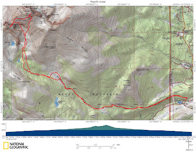
15.7 miles RT, 6850' gain
From Sandbeach Lake TH
Slideshow
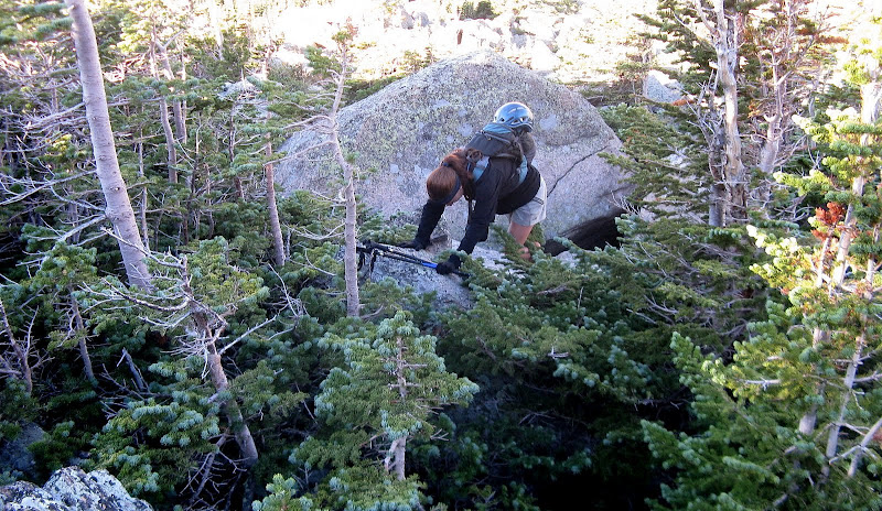
We meet at the entrance to Wild Basin and set out at 4:07am as it will be a long day ahead of us. The shortest approach to Pagoda is via Glacier Gorge, but the south side of Pagoda and Longs would be new terrain for me. We plod up the luxurious Sandbeach Lake trail until it crosses Hunter Creek after 3.2 miles. There is a decent trail heading north along the creek to a meadow south of Meeker, which shaves off some bushwacking. There is plenty of deadfall over the trail to negotiate though, and it must have rained hard the day before as we're getting soaked. Our feet are water logged and my hands are actually getting cold in August! This drops our morale a bit, and we press on to get into the sun!
We follow the creek until about 11K, then decide to head north instead of heading to the little lake further west. The bushwacking intensifies as we climb higher and we're deposited into a field of huge boulders interspersed with little spruce trees. Sometimes we use the trees to aid in stepping across gaps in the boulders and a new bushwacking skill is learned today! I think we end up scrambling more below treeline than above.
Mixed bushwacking:
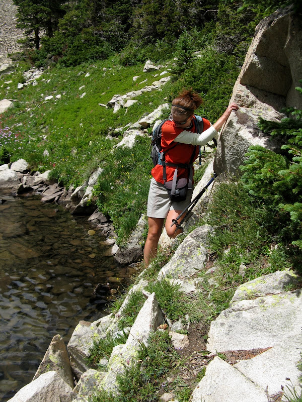
We press onward in search of pleasant grass, avoiding willow whacking when we can. There is no way to avoid the willows in this basin unless you go way out of the way, so we bite the bullet and press through the short stretches. There is so much water in this swampy terrain that our shoes are almost sucked off! We zig back and forth across the creek linking grassy patches and the difficulties relent. We soak in the views at this majestic, secluded place.
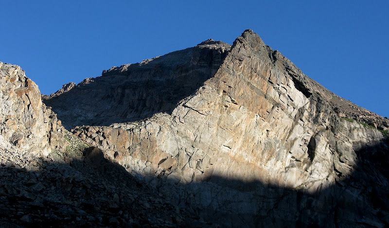
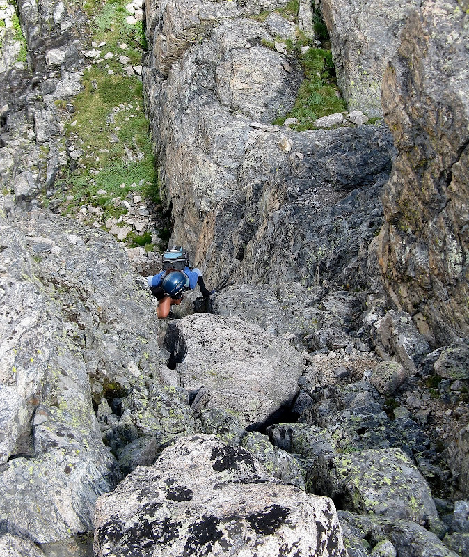
Pagoda's east buttress:
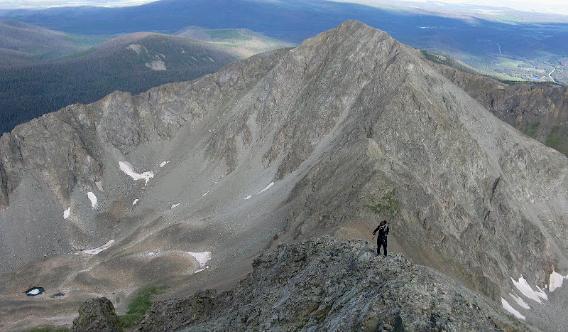
After a snack/wring the socks out break, we slog our way up talus and scree to the Pagoda/Longs saddle. From the saddle, it's a 400 foot boulder hop to the summit with a class 3 move here and there. We top out at 10:15 and the clouds are building fast. We're not sure if the weather will hold long enough to scoot over to Longs. The views from this forgotten summit are phenomenal. Longs looks pretty tough from this vantage point, but believe it or not there's a relatively straightforward route across the south face to the Homestretch if you know where to hunt around!
Hopes of making it over to Longs are low, so we explore the named tower near the saddle called Keyboard of the Winds. It only has 40' of prominence, but there are no scrambling options on this bad boy! We waver on whether to press on or not. We start heading down, but are encouraged by some blue skies to the west. We decide to give it a shot since we have a quick bailout at the top of Keplinger's Couloir to safe ground if the weather closes in. The lure to Longs is it will be a new route for both of us.
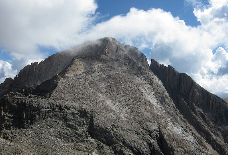
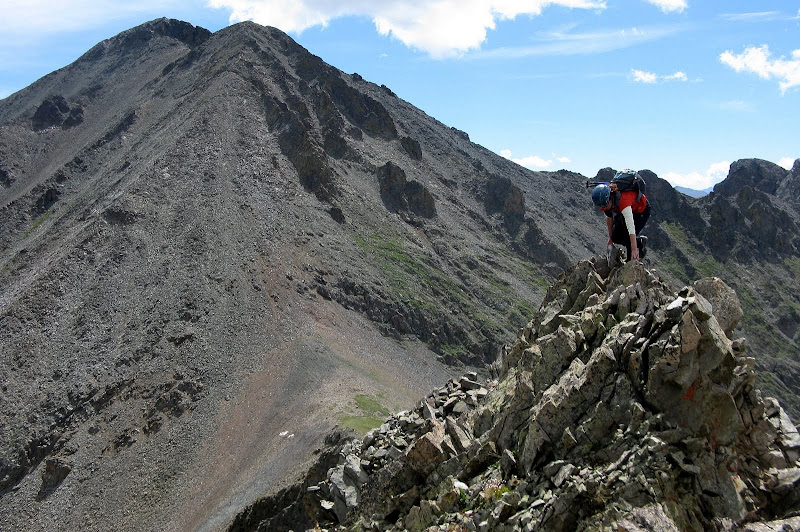
Most people do not climb Pagoda and Longs together even though they are close because there's a huge cliff band to split and it's a big day just to get one. We easily scoped out the weakness in the cliff band from Pagoda. There is a fairly wide, grassy ledge that you enter on the north side of the cliff band that traverses south to an obvious gully. The gully has two options and the easiest exit is right where there's only a few class 3 moves and a big cairn on top. It is crucial to find this cairn if coming from Longs.
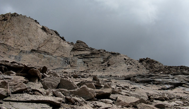
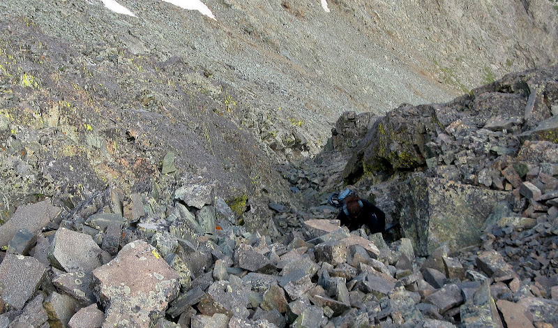
The key gully to traverse to is shaded right of center:
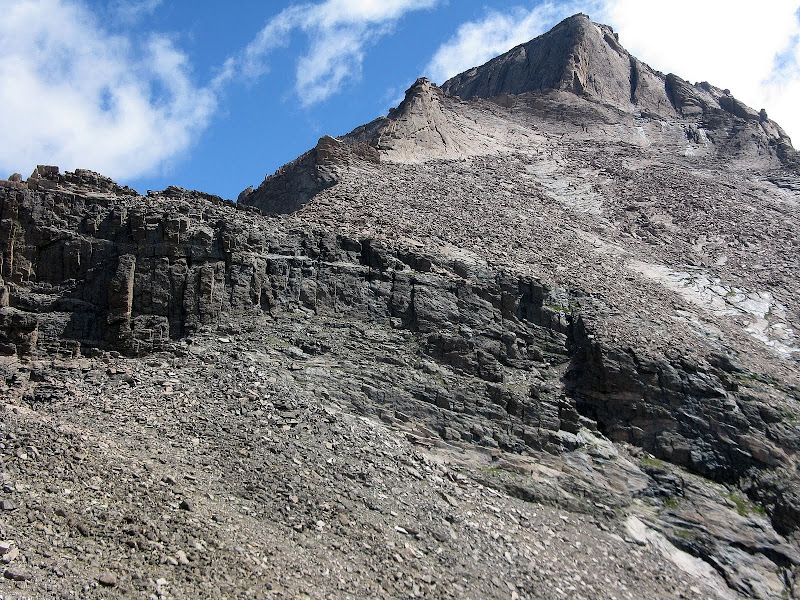
There is water running down the steeper gully, but the easier one is dry:
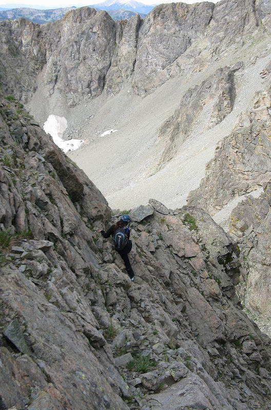
Once above this, there are sporadic cairns that we follow as we do an ascending traverse to a notch just before the Homestretch. This traverses below the Narrows, so we keep our helmets on. The key is to avoid the slabs and to not try to enter the Narrows too early, otherwise you will cliff out. The weather is looking like it will hold long enough for a summit bid.
Below the Narrows:
The Homestretch goes pretty quick as there's only one guy on it this late, and we top out at 12:45. The clouds are looking very ominous to the north, so we hang around just long enough to sign the register.
Homestretch Video
The advantage to our descent route is we can descend much faster than the Keyhole route. We actually entertained the idea of descending the Keyhole, but decide not to with the iffy weather. We reverse our tracks to the notch at the end of the Homestretch, then traverse slabs down to the top of Keplinger's. A few of the slabs are wet, so we take our time.
The descent of Keplinger's is hideous without snow, 1700 feet of rubble surfing. There is a beaten path in spots to take the pressure off the knees. The basin can come no sooner and we're relieved to be off the steep stuff. Now we JUST have 2 miles of open terrain and bushwacking left back to the Hunter Creek trail. This time we stay further east to avoid the nasty boulder field that we hit on the way up. The tradeoff is a 10 minute willow bash with a creek flowing underneath. It's worth the tradeoff! I'm impressed by Stehpanie's spirit of adventure, taking the brutal bushwacking in stride. It finally starts raining at 3pm, but it's light and the skies clear to bluebird status in 15 minutes. The bushwacking coming down is a cakewalk and we're back on the friendly confines of the Hunter Creek trail. The Sandbeach trail seems to never end and I inadvertently play mind games with Stephanie telling her my waypoint says only .7 mile to go! Unfortunately, it was the wrong waypoint for the much closer Wild Basin trailhead. We're pretty exhausted from a 6800' day and don't make it down until 6:45. Another sweet day in RMNP!
Never Summer Debut
Mt Richthofen (12940')
Mt Mauler (12493')
Never Summer Range
August 7, 2010
4.8 miles RT, 3200' gain
From Lake Agnes TH
Slideshow
The Never Summers in Colorado are a secluded range that tend to get ignored since there's nothing but "lowly" 12ers and below up there. The closest I had come to visiting them was to do nearby Clark Peak since it is a county highpoint, but it is technically in the Medicine Bows. Richthofen is a prominent 12er that is on the top 100 prominence list. I read about an interesting traverse that Layne Bracy did last year to Mauler and it would be a short day assuming we didn't screw up on the traverse!
DISCLAIMER: The nature of the rock in this range is very loose. One should be comfortable with your routefinding abilities and should test holds frequently. This is not a traverse to be taken lightly even though it is short.
I wasn't too motivated to get up after a huge day on Longs and Pagoda, so I set a 5am start time. I get perhaps the best night of sleep in my 4Runner. Stephanie pulls up right on time and we're off at 5:15. We don pants and gloves as it's probably in the 40's at the trailhead. I guess that's why they call it the Never Summers! We cruise on up the well built Lake Agnes trail and follow the loop around the west side of the lake.
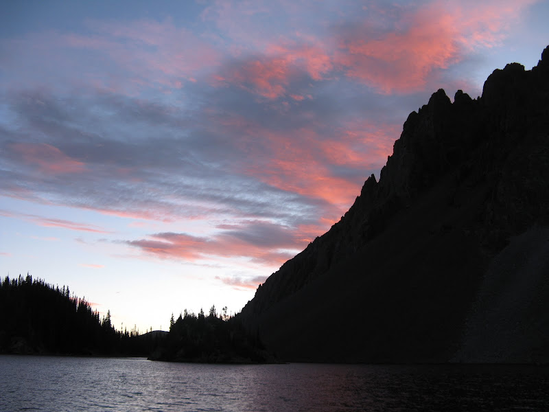
Sunrise over Lake Agnes and Nokhu Crags:
We leave the friendly confines of the lake at the south end and talus hop for awhile before heading for a grassy bench. We get sucked too high on the bench and end up on the lower flanks of the n.w. face, so before it gets too loose we scamper over to the talus grunt to the saddle. Richthofen is a cool peak, but the lower part of the west ridge is pretty loose. There is a decent trail in spots to aid progress. The ridge narrows out a bit, but is very straightforward.
The crux of the climb is a class 3 chimney just below the summit. There's enough loose rock in it that we go one at a time. We top out at 8:54, a bit longer than expected, but we're moving slow from the long day yesterday.
The crux gully below the summit:
It's quite windy at the summit and we take shelter for a few minutes to refuel. The descent is a bit annoying on the lower half of the ridge. Two guys come up and one is from Wisconsin climbing his first mountain. Sweet! We take a break at the saddle to prepare for the second half of the traverse to Mahler. It's only .4 mile and 400' to the summit, but there are quite a few obstacles to overcome.
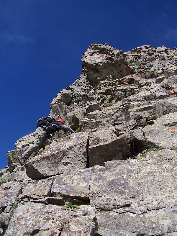
The first bit is easy. We go over a small tower, then are faced with the crux of the traverse. A deep notch blocks easy progress and one must downclimb into it, then climb the face on the other side. We find a 4th class descent that is cairned on top that goes pretty well and spot a narrow ledge below it that traverses south to easier terrain. There is a bulge on this ledge that we have to climb over.
Ledge traverse:
We find out later that there is a much wider grassy ramp that can be reached by dropping south off the ridge instead of west into the notch. There is a gnarly tower in the notch that we're easily able to traverse below on the south.
Our next obstacle is how to climb out of the notch. Exposed 3rd and 4th class terrain is the only option, so we traverse right and explore options.
Climbing out of the notch, pic courtesy of Stephanie Lynn:
The rock becomes more slabby the higher I get and I back off before over committing. The name of the game is don't climb what you can't downclimb! Steph doesn't like the way the ridge crest looks. I decide to check it out and it is one committing move on solid rock. I go right over the top of it while Steph gingerly skirts around it on the south side. There is a cairn on the south side of the ridge confirming that we are on route. The rest of the way still looks daunting, but is much easier than it looks. We drop below another tower without a problem and a short knife edge presents itself. I clean off the loose stuff and we go over the top of it.
After the knife edge there are a few short downclimbs and the final pitch is a climb up a class 2 gully on white rock up to the summit ridge, which provides some final solid scrambling. We top out on this exciting summit at noon. The register is actually on a lower summit a few yards to the s.w. I would classify the rock in the Never Summers as looser than the Gores but not quite as bad as the Elks. Test your holds on this traverse!
We descend down the north face to a high lake, which is a steep 900' balancing act down teetering talus. Most people go up and down this way, which would really stink! A ledge traverse above the lakes shores provides some entertainment.
We pick our way down to Lake Agnes, splitting the cliff bands on grassy ledges on the north side of the outlet stream. We wind around the east side of the lake this time and join the throngs of tourists as it's now a warm summer day down low. We're back at the trailhead at 2:50, a lot longer day than I thought! This is a great place to visit, but bring your A game if you decide to do the traverse!


Comments
Post a Comment