
-
 5093 Hits
-
 79.04% Score
-
 10 Votes
|
|
Mountain/Rock |
|---|---|
|
|
42.75713°N / 0.53777°E |
|
|
Hiking, Skiing |
|
|
Summer, Fall, Winter |
|
|
7884 ft / 2403 m |
|
|
Overview
 Pic de Céciré Summit Pic de Céciré Summit |
"Le Pic de Céciré est probablement le belvédère le plus remarquable de la région" - that's what the guidebook Guide Ollivier calls the mountain of theis page. And anybody who has stood on its summit can only agree - Pic de Céciré is a truly remarkable lookout. It is located to the north of the Pyrenees Main Ridge on a crest, which separates two of the best known cirques of the area, Cirque de Crabioules and Cirque d'Espingo. This quite naturally results in wonderful close-up views towards the mountains of the cirques. Moreover, thanks to its northern position, the vista from the mountain ranges from the Pica d'Estats in the east to the Néouvielle Group in the west with the omnipresent Pic du Midi de Bigorre in the north(-west).
 |  |  |
The shortest ascent to Pic de Céciré covers little more than 600m - 700m of elevation gain, which adds to the popularity of the mountain. It starts at the huge parking lots of the ski resort Superbagnères (itself quite a sight sore) and follows the Chemin des Crêtes towards a saddle, Col de Coume de Bourg, right in the vicinity of the mountain. The even more direct route along the east ridge cannot be recommended any more since rockfall took away part of it in (not so) recent years.
 |  |  |
Another, longer but more spectacular ascent route starts at les Granges d'Astau to the west of the mountain, touches upon several lakes (Lac d'Oô, Lac d'Espingo, Lac Saussat) and crosses several crests and saddles before reaching the summit. At more than 1200m elevation gain the route is a more serious undertaking but lakes and saddles offer a lot of diversion.
Seen up close Pic de Céciré releals itself as a twin summitted mountain. To the south-west of the main summit, and separated by a slightly pronounced saddle, there is Soum de la Coume de Bourg, a more or less round-topped summit. The main summit itself is similarly round topped and grass covered but also has a horseshoe shaped north-east face, which closes in a small cirque of its own. It is here that the Superbagnères ski runs have their topmost end.
 |  |  |
Pic de Céciré is a destination for all seasons. In Spring and winter ski and snowshoe tours are possible while in summer and autumn the mountain is hiked a lot. Moreover, the Pyrenees long distance trekking trail GR10 runs close by (through Col de la Coume de Bourg), in fact connecting the two aforementioned trailheads at Superbagnères and les Granges d'Astau.
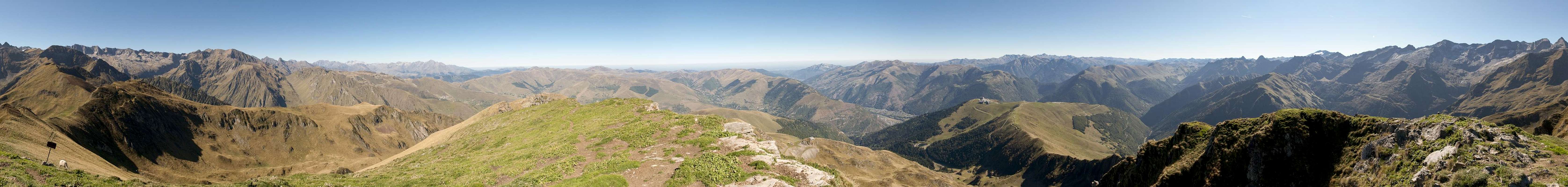
360° Summit Panorama
  |
Getting There
 The ascent ridge between Superbagnères and Céciré
- From France
- Take motorway A64 to the exit Montréjeau
- Take A645 to its end near Loures-Barousse
- Switch To N125 which leads you to Bagnères de Luchon.
- For Superbagnères follow the signs which will lead you into Vallée du Lis and up to the ski resort.
- For Lac d'Oô Take D618 to Col de Peyresourde.
- In Castillon de Larboust turn onto D76 through Oô to the trailhead at les Granges d'Astau.
- From Spain
- Take motorway A2 to Lerida
- Switch to N230 which will take you all the way to Vielha and Bossòst
- Turn west on N141 to Col de Portillon
- On the French side the Road (D618A) leads to Bagnères de Luchon.
- For the trailheads follow the instructions above.
Red Tape
 Griffon Vulture soaring the south slopes of Céciré
Pic de Céciré is part of the Superbagnères ski area, Thus there is little red tape to be found. The pastures beneath the summit are used for sheep and cattle grazing and you can be sure to find griffon vultures soaring along the ridgelines.
Accommodation
 Cirque de Crabioules with Céciré to the right
Being a spa town and ski resort, Bagnères de Luchon offers lots of accommodation of all kinds, the closets one in Superbagnères. For more information follow the following link:
http://www.luchon.com/
Weather Conditions
Maps & Books
- Luchon - Comminges - Louron
1:50000
Rando Editions
ISBN: 978-2-84182-343-7
- Pyrénées Centrales V
Vallées d'Aure et de Luchon
Guide Ollivier
Editions Cairn
ISBN: 978-2-35068-173-3
- Pyrenäen 2 / Pyrénées 2
R. Büdeler
Rother Verlag
ISBN:
978-3-7633-4308-9 (German)
978-3-7633-4918-0 (French)
978-3-7633-4826-8 (English)