
-
 4217 Hits
-
 79.04% Score
-
 10 Votes
|
|
Mountain/Rock |
|---|---|
|
|
42.85403°N / 0.12756°E |
|
|
Download GPX » View Route on Map |
|
|
Hiking |
|
|
Spring, Summer, Fall |
|
|
8524 ft / 2598 m |
|
|
Overview
 Pic de la Hourquette d'Aubert seen from Lac d'Aubert Pic de la Hourquette d'Aubert seen from Lac d'Aubert |
In the central part of the Néouvielle Natural Preserve you can find a number of granite mountains, which appear to be rather insignificant compared to their neighbours like Pic de Néouvielle or Pic des Trois Conseillers. Yet they are wonderful lookout peaks and since some of them are easily reachable makes them popular in addition. This is certainly true for all the peaks in the vicinity of Hourquette d'Aubert and Col de Madamète, two saddles which are part of a wonderful round tour, which visits about a dozen of the lakes of the area. In particular the ridge between the two saddles is of interest, as it contains three easy summits: Pic de Madamète, Pic dets Coubouts and unnamed Pic de la Hourquette d'Aubert, which is the topic of this page.
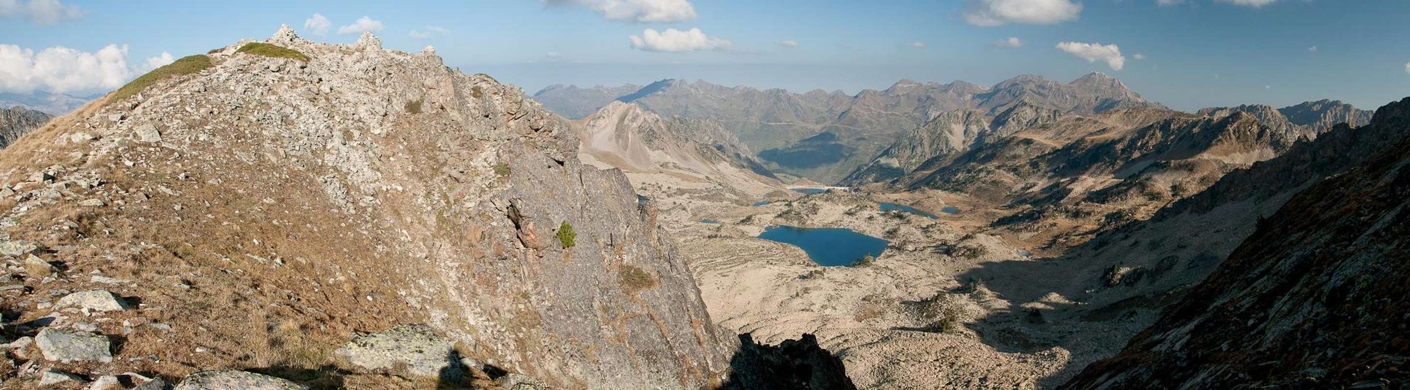
As you reach the parking lot at Lac d'Aubert and take a look across the lake your attention is immediately drawn by the mountain which rises at the northern end of the lake. It is a granite mountain with an easy west slope but sheer cliffs to the north and south, which is connected by a rocky knife-edge ridge with its eastern neighbour Pic dets Coubouts. Pic de la Hourquette d'Aubert has two summits of nearly equal height which tower above north and south face respectively.
 |  |  |
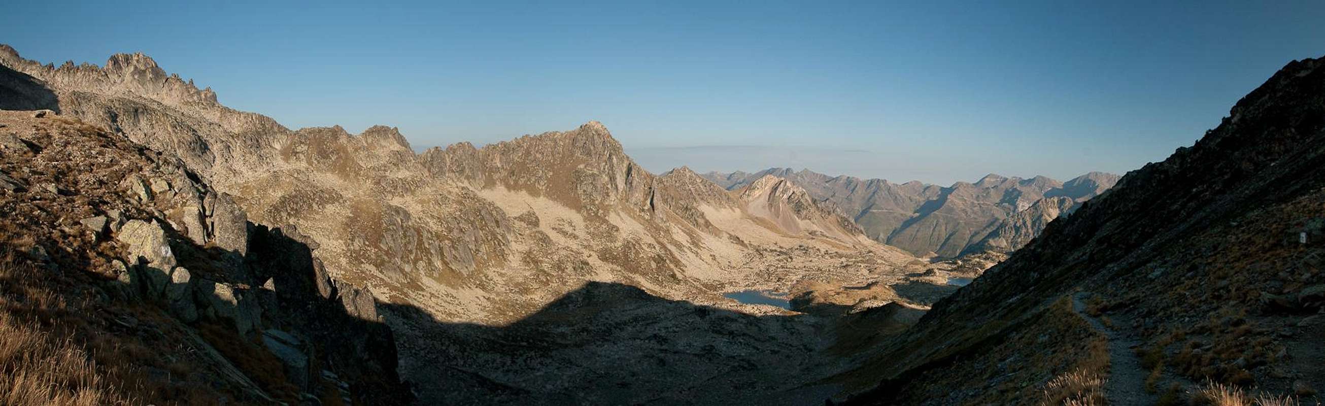
The mountain can be easily approached from Lac d'Aubert and summitted in less than two hours. A popular hiking trail gradually rises above the east shore of the lake, heading for Hourquette d'Aubert right beneath the west slopes. From here an unmarked path leads you easily to the base of the summit block where a little scrambling takes you to the top of the north-east summit. A short rocky traverse takes you to the south-east summit, where the east ridge to Pic dets Coubouts starts.
 |  |  |
Pic de la Hourquette d'Aubert is a good lookout peak. Thanks to its central location it offers a perfect overview over the Néouvielle Natural Reserve. The best time for a visit is around noon as a sunrise above Aneto and a sunset above Néouvielle spoil the views earlier and later in the day. From the top of the mountain you can count about a dozen lakes, mainly on its northern side.
360° Summit Panorama
  |
Getting There
 Pic de Néouvielle
There are two possible trailheads, one in the south, one in the north of the mountain. The northern one, however, which starts near Tourmalet Pass (at the botanic garden west of the pass), is very long and you will certainly not use it to climb an insignificant mountain like Pic de la Hourquette d'Aubert. Therefore only the southern itinerary is described here.
- Follow the Bielsa Tunnel Road between St Lary-Soulan and Bielsa.
- At Aragnouet-Fabian the road to the Route des Lacs turns off northward
- Ignore the trailhead for Lac d'Oule at Artigusse.
- Stay on the road until you reach Refuge d'Oridon.
- Turn off right, pass the refuge and head to the parking lot at Lac d'Aubert.
Red Tape
 |
The mountain is part of the Réserve Naturele de Néouvielle. The reserve was created in 1936 and is one of the oldest of its kind in France. It includes an area of more than 2300ha. The usual restrictions apply.
During the high season in summer you will have to pay fees for access and parking. Currently the fees are at €4 for Adults, €2,50 for children and €5 for parking (more than 8h).
Accommodation
The Vallée d'Aure is one of the most popular ski resorts of the French Pyrenees. Thus there is lots of accommodation to be found. The closest campground is near Fabian at Le Pont du Moudang on the Bielsa Tunnel Road. The following link gives you all sorts of information about the greater area including accommodation:Office de Tourisme de la Valée d'Aure
Weather Conditions
 |
Maps & Books
- Bigorre
1:50000
Rando Editions
ISBN: 978-2-84182-413-7
- Pyrénées Centrales IV
Luz-Barèges-La Mongie-Payolle-Bagnères de Bigorre-Gèdre-Saint Lary
Guide Ollivier
Editions Cairn
ISBN: 978-2-35068-173-3
- Pyrenäen 2 / Pyrénées 2
R. Büdeler
Rother Verlag
ISBN:
978-3-7633-4308-9 (German)
978-3-7633-4918-0 (French)
978-3-7633-4826-8 (English)
visentin - Apr 2, 2012 3:36 am - Voted 10/10
Pic d'AubertUsed to be the ancient name for Pic de Néouvielle until it was named as presently. Nowadays, since "P2580" (2599m on IGN top 25 map) is located right from the Hourquette d'Aubert, most people call it "Pic de la Hourquette d'Aubert" or Pic d'Aubert if lazy (despite unnamed it's not so unpopular as a hiking goal, as it ends somehow logically the "typical touristic hike" of the lakes area). I would prefer to see a real name than "P2580" but it's up to you. For my own curiosity I'm going to ask some history experts of my former home mountain club to see what they say about it. Another option: name it simply Pic dets Coubous, after all it's a very close fore-summit. You've climbed so many peaks across the world that there is no shame to tick this ascension as "uncomplete" ;) There are some photos I can add on it too, I'll try to do it soon. Eric (hoping to see Levka Ori in the skyline is less than a week !)
visentin - Apr 2, 2012 5:03 pm - Voted 10/10
Re: Pic d'AubertOne of the historian folks I asked about this peak told me all old maps do not mention any name except a 1947 one that says "Pointe occidentale de la Hourquette d'Aubert". A bit long, but "Pic de la Hourquette d'Aubert" seems to meet the consensus amongst everyone. Because indeed, this peak is much more popular than I thought, almost everyone I asked has climbed it ! And everyone confirmed that the panorama you get from it is first class, so it's a well deserved place on SP. Just one detail: I don't think it's possible to spot the Aneto from here. It's too far and we are too low, there are too many three-thousanders in between (Lustou group for example)
Gangolf Haub - Apr 3, 2012 3:33 am - Hasn't voted
Re: Pic d'AubertHi Eric, my first idea of a name would have been Soum de laHourquette d'Aubert. But I didn't find anything anywhere. Also I remembered you referring to it as P 2580 ;-) Will change ...
visentin - Apr 3, 2012 5:29 am - Voted 10/10
Re: Pic d'AubertSoum is a good one as it tends to designate a top of minor importance. Sounds much closer to the reality than "Pic" or "Pointe" ! You're getting expert in local dialects ;) p.s: change the height to 2599 too (IGN). The huge cairn could be meant to make it a "2600er" :)
Gangolf Haub - Apr 3, 2012 2:47 pm - Hasn't voted
Re: Pic d'AubertYou're right about the elevation. I didn't even look at my gps file, where the summit is at 2598m