
-
 3826 Hits
-
 85.36% Score
-
 20 Votes
|
|
Mountain/Rock |
|---|---|
|
|
43.72884°N / 109.94382°W |
|
|
Hiking, Scrambling |
|
|
10617 ft / 3236 m |
|
|
Overview
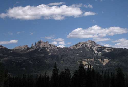
Overview-- The PeakSoutheast of the main summit are two peaks that both have enough prominence to qualify as ranked ones. "Pinnacle Buttes-- Southeast Peak #2" is the more southerly of the two and is the closest of all five Pinnacle Buttes summits to a paved road. It is also the easiest to climb; my understanding from someone else I know who has climbed the peak is that it is a walk-up, though I opted for something a little more adventurous that threw a lot of fun scrambling on sketchy rock my way.
The summit has jaw-dropping views of the main summit and the other southeastern summit, which happens to be the hardest and the scariest of the five to climb. Those views are so stunning that it is almost possible to forget about the wonderful views in every other direction. Nearby Absaroka peaks such as Lava Mountain, Two Ocean Mountain, and Mount Sublette are in full view, and on clear days one can see the highest peaks of the Wind River Range, the Gros Ventre Range, and the Teton Range.
The summit has jaw-dropping views of the main summit and the other southeastern summit, which happens to be the hardest and the scariest of the five to climb. Those views are so stunning that it is almost possible to forget about the wonderful views in every other direction. Nearby Absaroka peaks such as Lava Mountain, Two Ocean Mountain, and Mount Sublette are in full view, and on clear days one can see the highest peaks of the Wind River Range, the Gros Ventre Range, and the Teton Range.
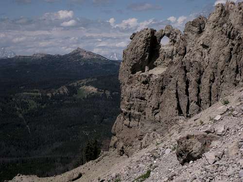
Breccia Arch
Getting There and Route Information
Finding the Trailhead
About 7 miles east of Togwotee Pass on U.S. 26/287 northwest of Dubois, turn onto the road for Brooks Lake and follow this good unpaved road for about 3.5 mi to a signed parking area for the Pinnacles Trail. This road is passable for passenger cars.
Climbing Route
The trailhead is at about 9100'. Hike the trail for about 3 miles, climbing gradually. It crosses some streams along the way (in August, some were dry and the others were very easy to cross), losing a little elevation as it does so, but there are no serious dips that have you hating the trail. At a little over 10,000', the trail emerges from the trees and crosses rocky slopes. Either continue on a little to find the walk-up route my friend mentioned or start heading up the steep breccia slopes. The latter is more direct-- no more than half a mile to the summit-- but also more challenging, as you will probably be dealing with steep Class 3/4 terrain on some of the most brittle rock to be found in the U.S. Rockies and perhaps anywhere. The scrambling ends almost at the very highpoint itself.
 |  |  |
On my descent, I decided to try a prominent gully that leads right up to the summit. The upper end looked a little too steep to enter from the summit itself, so I descended south and east a little before getting into it. Then I was able to make a fast trip down loose scree and then follow broader scree slopes back down to the trail. This was a Class 2 way, but it was so steep and loose that ascending it would not be enjoyable; personally, I think people used to scrambling and loose rock would prefer to work their way up among the more "solid" breccia formations here.
 |  |  |
Red Tape, Camping and Lodging, Links
Red Tape
This is prime grizzly country, which means special rules about food storage and personal behavior are in order. I will not list them all here. Bottom line: If you don’t know, don’t go.
Camping and Lodging
The Brooks Lake and Pinnacles campgrounds are both located about a mile past the turnoff for the trailhead. Summer 2007 fees were $10/night. Both are small campgrounds that operate on a first-come, first-served basis, and Brooks Lake is very popular with fishers, so don’t show up after 3 P.M. on a nice summer day and expect to find an open site. The campgrounds have trash bins, bearproof lockers for food storage, pit toilets, and water (though the water at Brooks Lake was shut off in July 2007). Both campgrounds are among the most scenic developed campgrounds you will ever see. Brooks Lake is surrounded by open meadows and towering cliffs and pinnacles.
Off 26/287 very close to the Brooks Lake turnoff is the Falls CG, operated by the Forest Service. It is a large one and will usually fill late if at all.
If you don't want to camp, Dubois has plenty of motels. Should you prefer a bed but want to get away from town, you could consider the Lava Mountain Lodge, which is between Dubois and Togwotee Pass. In 2001, I stayed there when it had a different name and was under different ownership, and it was a nice place to stay. Although I have not stayed there under the current management, I have stopped there a few times for gas, snacks, and drinks, and the staff has always been very friendly.
But if you really want to get away from town, experience the scenery, and enjoy top-rate food and lodging, look into the Absaroka Ranch, up the Du Noir Valley. It caters more to groups and extended trips, but if you are out here for a week or two, this could be a really nice option. SP member Doublecabin works there, and his family owns the ranch. I was fortunate enough to be a guest there for three nights in August, and I can say that the scenery is amazing, the food is great, and the people are very friendly.
External Links
For more information on camping and regulations: Shoshone National Forest.