
-
 22654 Hits
-
 86.85% Score
-
 23 Votes
|
|
Mountain/Rock |
|---|---|
|
|
46.10180°N / 8.03101°E |
|
|
Weissmies massif |
|
|
Mountaineering |
|
|
11995 ft / 3656 m |
|
|
Overview
Pizzo d'Andolla
What's New on this Page?
* Jan 6, 2023 - Ownership switched by Antonio Giani
* Jan 6, 2023 - Page under review
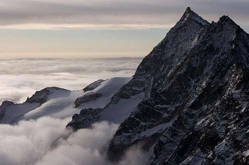
Rocky peak, pyramid shaped and placed at the junction between the valleys "Antrona", "Saas" and "Zwischbergen".
It's the highest peak of the chain watershed from "Montemoro pass" to the "Zwischbergen pass"; and it's the southern peak of the massif almost totally in Swiss region composed from north to south by Fletschorn,Lagginhorn and Weissmies. Magnificent pyramid from the Italian side but a long crest not very impressive if seen from the Almagellertal(Saas side). It is formed by three main rocky ridges. The first two, on the border crest from the Porta di Loranco to Andolla pass, where they fall on the Italian side with numerous jagged ridges that enclose remains of ancient almost extinct glaciers.
The Italian side hosts the major and difficult routes. While, the northern ridge divides the valley of Saas from the valley of Zwischbergen.
Both flanks covered by glaciers, which are the Rotblattgletscher (west side) and the Zwischbergengletscher (east).
The Italian name of the mountain, derives from its Andolla homonymous belower pastures. The sense of the Swiss name, should be: "Portjengrat", "Portjen-ridge", "Ridge of Porta (di Loranco)".
The arrival on the top of the Andolla is always an emotion, thanks to the engagement, the attention, the labour. But must not forget that the top is not the end of the excursion because the descent is longest and more difficult.
 |
 |
 |
 |
 |
 |
Getting There
From Swiss:
Almagellertal: This valley is part of the major Saastal. Reachable by car or buses from Sion or Brig. The support point is the Almageller hutte.
Zwischbergental: Also called "Val Vaira". Very wild valley, with along approach. Usefull also for the southridge route to weissmies; but not commonly used because no huts and bivouacs in the area. The starting point for the valley is the hamlet of Gondo alog the Simplon road between Domodossola (IT) and Brig (CH).
From Italy:
Valle Antrona: This valley start from the village of Villadossola, few km before Domodossola. Reachable from Milano and Varese by bus, train and car. The last hamlet of the valley is Antonapiana (902m), where a path takes to the Andolla hut.
 |
 |
 |
 |
 |
Route history
- East ridge: Moritz von Kuffner, Alexander Burgener, J. P. Ruppen 15/07/1890.
- Southeast ridge: Aldo Bonacossa, Gigi Vitali 06/08/1947.
- Northeast wall: Franco Fontana, Benito Giovannone 17/08/1974.
- Southeast spur: Aldo Bonacossa, Alberto Malinverno 24/07/1941.
- South wall 1: Franco Farioli, Dante Valterio 07/1967.
- South wall 2: Marco Borgini, Anna Detoni 12/07/1987.
- South wall 3: Franco Fontana, Stefano Pioda 22/08/1976.
- Northeast ridge: Giuglio Bevilacqua, Aldo Bonacossa 27/07/1919
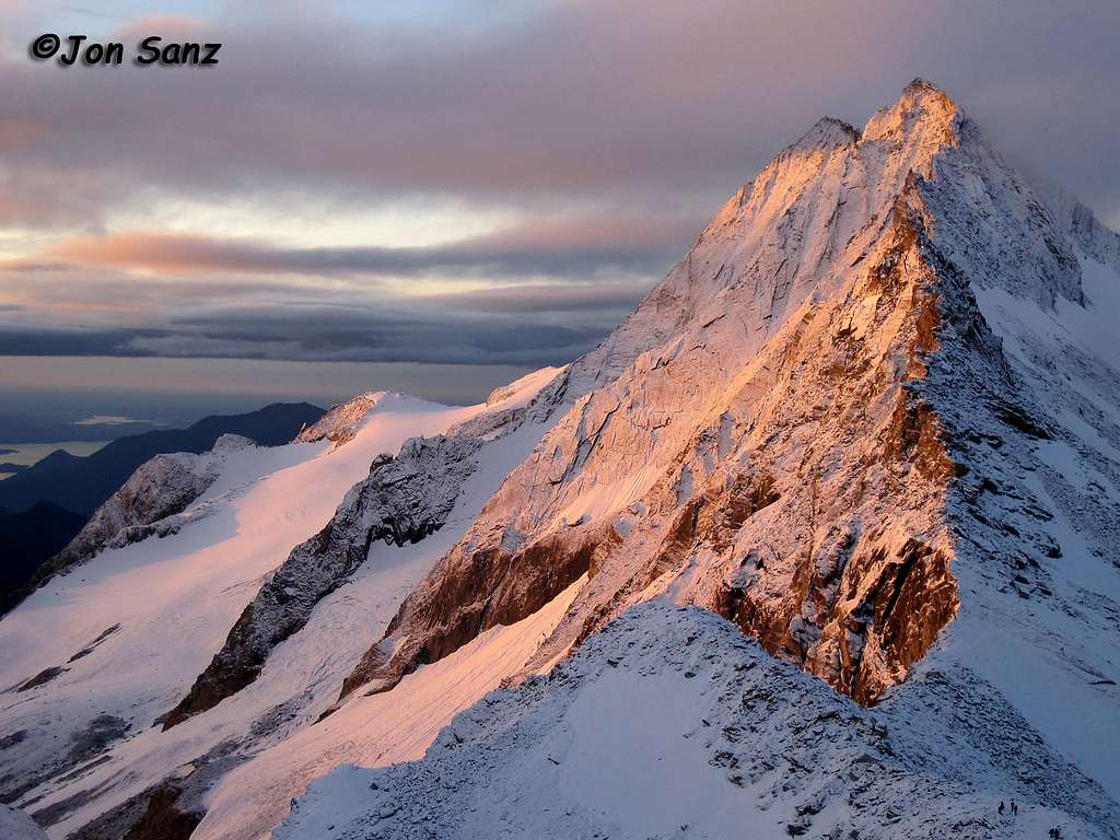
Portjenhorn, Pizzo Andolla in Italian, its a very fine peak of 3656 meters very close to the boderline of Zwitserland with Italy, just at the SSE of the Weissmies. This image was taken just a little bit higher that the Zwischbergenpass (3.268 m), between Weissmies and this elegant peak, at sunrise, after a cold night snowing in july, 22, 2011.
Routes
East ridge: Italian normal route. From ref. Andolla 5h'00/7h'00. (II°/III° AD-). Long route and not easy to recognize.Southeast ridge: From biv. Citta' di Varese. (650m III°/IV° D).
Northeast wall: From biv. Citta' di Varese. (600m IV°/V° D+).
Southeast spur: From biv. Citta' di Varese. (500m III°/IV°+).
South wall: via Farioli/Valterio From biv. Citta' di Varese. (450m IV°/IV°+ D) via Borghini/Detoni From biv. Citta' di Varese. (300m V°/V°+ TD-) via Pilastro Murgia From biv. Citta' di Varese. (350m V°/V°+ TD).
South ridge: Probably the best. From Porta di Loranco. (400m III°/III°+ AD+).
North west ridge: Swiss normal route. From Almegeller hutte. (750m II°/III° AD).
Northeast ridge: Not recomedded. From Swischbergergletscher. (II°/III° AD).
Accomodation
Almageller hutte: LINK (2.894 m) SAC Niesen. Tel 0041/279571179.120 places (13 winter room) Open from june to september. From Saas Almagell (3h'00 EE).Refuge Andolla: LINK (2.061 m) C.A.I. Villadossola.Tel 0324/575980.76 places (17 winter room) Open from june to october.From Antronapiana (2h'00 E).
Bivouac Città di Varese: LINK (2.650 m) C.A.I. Varese 9 places. Situated at the foot of the south wall. Always open. From Ref.Andolla (2h'00 EE).


External links and maps
www.saas-almagell.chA website for the village of Sass Almagell and all the Sasstal
www.valleantrona.com A website for the Antrona valley
For any information about the Valley of Domodossola Maps: - Simplon, Landeskarte der Schweiz, 1:25.000. - 5006 Matterhorn-Mischabel, Landeskarte der Schweiz,1:50.000. - Kompass, Monterosa 1/50000 n°88.