
-
 2821 Hits
-
 84.27% Score
-
 18 Votes
|
|
Mountain/Rock |
|---|---|
|
|
42.34357°N / 0.59772°W |
|
|
Hiking |
|
|
Spring, Fall, Winter |
|
|
5233 ft / 1595 m |
|
|
Pusilibro - Puchilibro
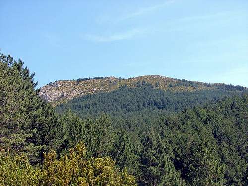
View from Loarre. June 2009.
It’s said that you can see the towers of the Basílica del Pilar - otherwise known as Zaragoza Cathedral - from the summit of Pusilibro/Puchilibro. Whether you can may depend on luck, good eyesight or imagination. Without a doubt you can see a grand panorama of Pyrenean peaks, the Hoya de Huesca basin (south) and the Sierra de Guara (east).
THE AREA: A chain of hills around 1,500m altitude runs east-west to divide the Hoya de Huesca basin south from the pre-Pyrenean sierras to the north. The area running along the banks of the River Flumen is often called the “Reino de Los Mallos” - (Kingdom of the Mallos) – best known for the wonderful mallos at Riglos but which also includes among others: The Sierras de Agüero (with its own “mallos”), Murillo, Marcuello, Loarre, Bolea and Ayerbe.
PUCHILIBRO/PUSILIBRO is the highest point in the Sierra de Loarre, residing over the famous Loarre Castle or Castillo de Loarre to its south and to the north the big Pyrenean peaks. On a clear day you may also see the city of Zaragoza's high point: Moncayó.
Various Options: Starting south of the peak in Loarre (or at the castle itself) it is a short, pleasant hike of 550m of ascent/descent: either there and back or a circuit.
From Rasal in the north a longer day (9km one way and around 900m accumulated of ascent/descent).
When? A route for any time of the year though best for a clear day. Mid summer/Mid winter temperatures can be extreme. Start early if you are walking in summer.
Red Tape? None. Beware of the danger of forest fires in dry seasons.
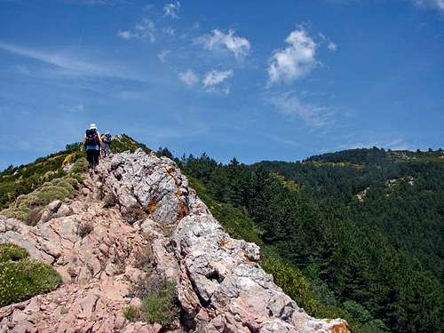 Ridge SE of Pusilibro. June 2009. Ridge SE of Pusilibro. June 2009. | 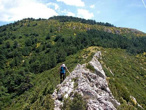 Ridge West of Pusilibro. June 2009. Ridge West of Pusilibro. June 2009. |
Note: I received this page of ojo (thanks).
How to Get to...
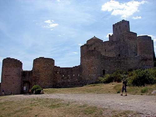
Castle of Loarre. June 2009.
... Loarre/Loarre Castle: The A-132 NW from Huesca, direction Ayerbe. Turn off right at Esquedas, just before km 14 and follow road to Bolea. Don’t enter village but continue towards Aniés. Again, don’t enter village but continue to between km 8 & km 9 where a road on the right directs you to Loarre Castle. (Plenty of parking).
....Rasal: from Huesca, head north on the N-330 (national road) towards the Monrepós tunnels. Before reaching the tunnels, turn left at the Arguis Reservoir and take a local road to Rasal (18km), avoiding the turning left to Bentué de Rasal (8km from Arguis). Take care on this narrow road. On reaching the village, don’t turn left towards the houses but contiune along the road until an obvious footpath sign post to Loarre just outside (west) of the village. The route starts here.
Routes.
ROUTE OPTION 1: There-and-Back or Circular route from Loarre (south).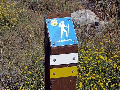
Path PR-HU 105. June 2009.
Start in the Loarre Castle car park (or you can pick up the footpath from the village of Loarre – add another couple of km) and look for the signpost of the PRHU105 heading north. Following yellow/white wooden posts, the path takes you into pine forest. At a signpost, take the right hand path (this is the junction for the return on the circular route). Continue ascending through forest until you reach a track.
(30 minutes) Cross the track and almost immediately opposite, wooden posts mark a small path that begins to ascend more steeply. Soon on a wide rocky ridge above the pines. (1 hr) Signpost. Ahead is the descent for the circular route and also towards Rasal. Take right hand path. Less than 60m of ascent and under 10 mins to the summit post.
To return: retrace steps or to complete the circuit: Return to the last signpost and follow the path right (direction Rasal).
This path is narrow but clear to follow (this comes from experience only in very poor visability on two occasions). Follow path down south/west into trees. This PR-HU route is marked but vaguely. There ought to be yellow/white marks on trees or rocks, but from experience they are sparse (and not visible if making the circuit in the opposite direction). This path will take you steeply down through pine forest and finally to a track. Look for a path that veers to the right and contines the descent until you come out into a flat area with a track and a tiny building.
Look for marks of the trail beyond the building and follow them over flat, open ground – general direction south - into more trees. This trail turns eastward and eventually takes you back along a woodland path to the first junction of the day and in a few minutes, back to the car park.
OPTION 2: From Rasal (north)
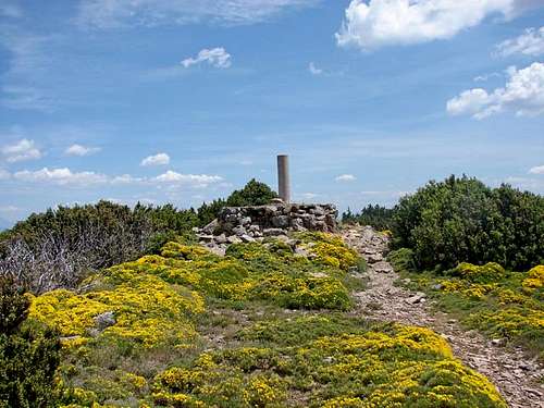
Summit of Pusilibro. June 2009.
The path levels out somewhat and begins to skirts the slopes to eventually arrive at a radio mast (1,386m) at col Artica o Curro, about 2km north of Loarre Castle (NB there is also a radio mast just west of this one, at 1,466m: Cubilar de Jimenez). Here there are views of the west flank of Puchilibro and over the flat lands to the south – the Hoya de Huesca basin. [img:684813:alignright:small:At the col Artica, Collarada in the distance.]
a) From the radio mast (1,386m) you can continue the PR 105 down to a track, turn left for a few metres and pick up the marked track north east through the trees. This option appears to be easy as it follows a marked footpath, but from personal experience it’s a bit hit-and-miss. If you are lucky to spot the markings, no problem. A post marks the path leaving the track, but this becomes the only guide and it may be just by chance that you pick up signs on the trees – or the odd cairn. (They are more obvious when descending this path, but still rather scarse). Head directly up from the track to pick up the path above the trees in a under 10 minutes (not easy going underfoot – fallen trees etc - especially in snow).
At the “col” – Portillo Chara - the route is clearer and you have some 300m of ascent – continuing steep at the start then cresting somewhat to reach a signpost. Turn left and in under 10 minutes you will have reached the trig point. (The path ahead at this last turning would take you down to the Loarre Castle following in reverse the Route 1 above).
b) Option from the Artica o Curro col (radio mast) look for a path (behind/east of the radio mast) that heads east (without losing height?) and follow what is called the “Faja Pilas” - less than 0.5km and virtually level - which runs east towards Portillo Chara col, meeting the steep pine wood path (the PR 105) coming up from on the left. Continue to follow the path zigzagging up some 300m more to a turning and signpost where the Loarre route is ahead, the summit to the left.
More stuff...
FURTHER INFORMATION: The following accommodation links are in Spanish.PLACES TO STAY: In Loarre village. The 3-star Hospederia de Loarre
Camping at Camping Loarre
This area is very popular for PARAGLIDING. ParaglidingEarth give GPS coordinations and video clip of gliding over Loarre.