
-
 3528 Hits
-
 77.48% Score
-
 8 Votes
|
|
Mountain/Rock |
|---|---|
|
|
47.07925°N / 12.15155°E |
|
|
Hiking, Skiing |
|
|
Spring, Summer, Fall |
|
|
9101 ft / 2774 m |
|
|
Overview
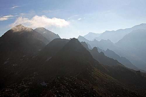
Morning scene on the summit of Schientalkopf/Schüttalkopf
The Name
It's interesting that on all maps I saw, this summit is written as Schüttalkopf, while on the summit cross it's written Schientalkopf.
The Summit Presented
It all looks that this humble summit has only one reason for existence - to enrich the otherwise already great trek over the Krimmler Tauern Pass, 2633 m. Since middle ages, if not since the times of antiquity, over this 2633 m high saddle there was a trade connection. Today quite frequented marked paths are reaching it from both, Italian and Austrian side. Even if the view from the saddle is great and even if that can be the ultimate goal of a trek, it is not a bad idea to ascend those 140 m more, as from the summit of Schientalkopf the views are still broader. And you can always find those 20 minutes of additional time.
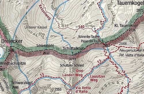
So, Schientalkopf is rising in the eastern part of Zillertal Alps (Reichenspitze group). In that section, the main ridge of mountains is running in the west-east direction. North of our mountain is the Windbachtal, south of it is the Valle Aurina (Ahrntal). The prominence of mountain is not a big one. The saddles on both sides are 2632 m and 2633 m high (Schoentaljoechl on the west and the famous Krimmler Tauern on the east. So, only good 140 meters of prominence. On the west, the first high mountain is Dreiecker, 2892 m, and on the east there's Tauernkogel, 2872 m.
From the Krimmler Tauern pass an easy, marked path goes by the ridge on the Schientalkopf. Even if most of the visitors are hikers during the summer season, the summit is suitable also for tour skiing. The downhill is more attractive on the Austrian side.
Summit Views

Towards Rauchkofel (W)

Towards Zillerplattenspitze (NW)
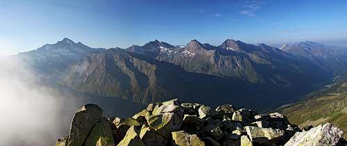
The great southern panorama
Getting There
To reach the summit of Schientalkopf, the trailheads are the same as for the Krimmler Tauern Trek, so:> Krimml, 1067 m, on the north (or Krimmler Tauernhaus, 1631 m, if you take a hut taxi) and
> Casere/Kasern, 1582 m, the end parking place in Valle Aurina, a bit further from Prettau, 1449 m.
Online maps:
> http://www.austrianmap.at
> http://www.kompass.de/touren-und-regionen/wanderkarte/
Summit Ascent

Summit cross
From the Austrian side you start the long hike either in Krimml, 1067 m, or at Krimmler Tauernhaus, 1631 m. Then you shortly follow the Krimmler Achental (main valley), but on 1666 m you deter right into the valley of Windbach. A good, centuries old marked path brings you on Krimmler Tauern pass. Some 4 h from Krimmler Tauernhaus, 7 h from Krimml (23.5 km).
From the Italian side you start the hike in Casere/Kasern, 1582 m. This ascent is steeper and shorter. You first walk up by the valley till some 1750 m, where the marked path No. 14 deters left. Then it goes in countless turns up, always towards the north. Some 3 h 30 min till the saddle.
The very summit ascent then actually requires no description. So, we start it on the famous Krimmler Tauern pass, 1633 m. It's interesting that there you can find many inscription plates, guiding you to destinations on both sides of the notch, but there is no plate or sign for the nearby Schientalkopf! But just around the corner, going westwards, a nice, marked path starts and you simply follow it by the main ridge. It soon loses a few meters of altitude, but then continues ascending. The path is well made, as it is a nice habit in this area, big granite plates are arranged in a comfortable pavement. Only a few turns just below the summit are steeper, but not difficult at all. On the Swiss Hiking Scale the difficulty grading would be T2, from the saddle you need 20 minutes for the ascent.
If you are not starting on the saddle, you can from the Austrian side gain the ridge east of the summit also by an easy pathless terrain. You just need to pay some attention to lose rock blocks.
Mountain Huts

Bivouac below Krimmler Tauern
Very close to the summit is Neugersdorfer Huette / Rif. Vetta d'Italia, 2568 m, on the Italian side of Krimmler Tauern. The hut used to be closed for public, but in summer 2015 it looked to operate.