
|
|
Mountain/Rock |
|---|---|
|
|
43.10000°N / 19.00000°E |
|
|
7555 ft / 2303 m |
|
|
Overview
 Sunset on Terzin Bogaz
Terzin Bogaz (2303 m) is one of most beautiful and most specific peak of DURMITOR. It's beautiful peak and more than 300 m high North Face dominate in central part of Durmitor massif, specially above incredible beauty of impressive glacial Lokvice Valley (1693 m). Terzin Bogaz summit offer a many nice panoramas, from which is maybe most impressive panorama of highest peaks of Durmitor -
LOCATION:
Terzin Bogaz (2303 m) is situated between Medjed (2287 m), on the N, and highest peak of Sljeme (2455 m), on the S. Together with Medjed peak, Terzin Bogaz is a part of the high and long "boomerang form" crest, which is vertically placed to 2 kilometres long crest of Sljeme (2455 m). From the Medjed peak it is separated by Velika Previja pass (2145 m). From Sljeme separates it Mala Previja pass (2200 m). Terzin Bogaz separates Lokvice valley in two parts. Highest part is on the south and is called Ledeni Do (Ice Basin). Larger northern basin is Lokvice. Above both basins Terzin Bogaz proudly staying with it's powerful, over 300 m high North Face, which is specially impressive and beautiful above Lokvice valley. On the E Terzin Bogaz falls into Velika Kalica valley.
SUMMIT VIEW:
SE view look to Zupci (2309 m)(Teeths), Bandijerna (2409 m) and Milosev Tok (2426 m).
SW view of Terzin Bogaz look to impressive massif of Durmitor and specially to it's highest peaks, Bobotov Kuk (2523 m) and Bezimeni Vrh (2487 m). Also, Lucin Vrh (2396 m) and Minin Bogaz (2387 m) "alpine needle" peak can be seen.
N view look to Medjed (2287 m) SW wall, Obla Glava (2303 m) and Cvorov Bogaz (2152 m), which can be seen above beautiful deep glacial Lokvice valley.
NE view look to pretty Savin Kuk (2313 m).
E view reach impressive 2 kilometres long high rocky massif of Sljeme (2455 m).
 |  |  |  |
Routes Overview
TERZIN BOGAZ (2303 m):Marks reached Terzin Bogaz from Velika Previja pass. This pass can be reached both from Lokvice and Velika Kalica valleys. It's summit is wonderful viewpoint. Difficulty of Terzin Bogaz climbing: VI+
1. Velika Kalica approach: Crno Jezero (1416 m) - Struga pass (1920 m) - Velika Kalica valley - Bivak refuge (2020 m) - Velika Previja pass (2145 m): 2.45 h
2. Lokvice approach: Crno Jezero (1416 m) - Indjini Dolovi - Katun Lokvice (1700 m) - Velika Previja pass (2145 m): 2.50 h
3. Route III: Velika Kalica valley (bivouac) - Velika Previja pass (2145 m) - Terzin Bogaz (2303 m): 1h
 |  |
Getting There
Terzin Bogaz (2303 m) North Face above beautiful glacial Lokvice valley in the heart of Durmitor massif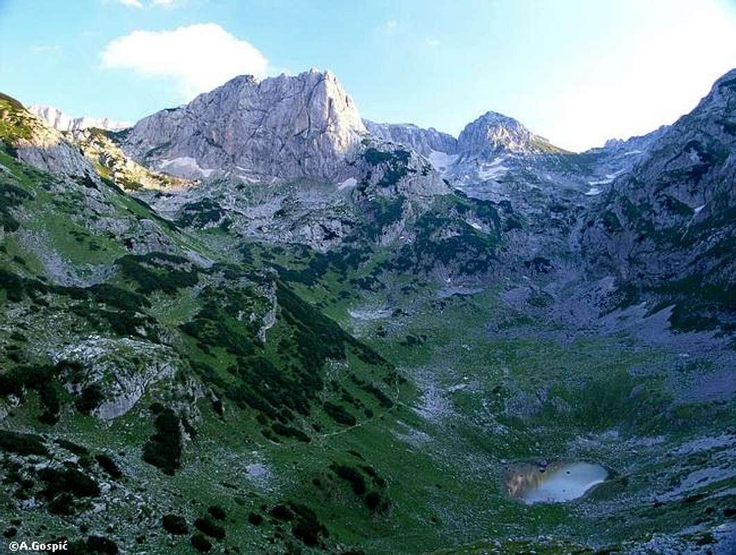
Gateway to climbing Terzin Bogaz (2303 m) peak in Durmitor massif is Zabljak town. Information how to get there:
By Plane
~To Beograd (Belgrade, Serbia&Montenegro capital) airport. Than with plane to Podgorica, capital of Montenegro, or with bus or car to Zabljak town.
~To Podgorica airport. Than with bus or car to Zabljak town.
Information about flights find on the sites of JAT Airways, a former Yugoslav airlines, or on Montenegro Airlines.
By Bus
~Beograd (Belgrade)-Zabljak
~Podgorica-Zabljak
~Niksic-Zabljak
~Pljevlja-Zabljak
Buses go to Zabljak from Beograd (Belgrade) twice a day and from Podgorica, Niksic, Pljevlja and Mojkovac several times per day.
By Car
~Beograd (Belgrade)-Zlatibor-Nova Varos-Prijepolje-Pljevlja-Zabljak
~Niksic - Savnik (47km) - Zabljak (37km): 84km; Niksic to Zabljak approach from south.
~Niksic - Savnik (35km) - Zabljak (37km): 72km;
~Podgorica - Niksic (55 km)-Savnik (47 km)-Zabljak (37 km): 139 km; Add this length if you are going to Zabljak from Podgorica via Niksic. Road to Niksic from Podgorica is good.
~Podgorica - Kolasin (71km) - Mojkovac (21km) - Zabljak (67km): 159km; road is good all the way to Zabljak. Behind Podgorica (56m) you go inside Moraca River canyon (one of spectacular Montenegrin canyons). It is up to 1000m deep and has wild sides. That's spectacular drive. After that, from "Djurdjevica Tara" bridge to Zabljak - 23 km.
 |  |  |
When To Climb
You can climb during all year seasons, but ideal period for climbing is mid June - mid September.During the winter, Durmitor usually switches into ski resort. Under Savin Kuk peak (2313 m) is Durmitor Ski Center. (gondolas, ski lifts, chair lifts, restorants and their customers).
Crno Jezero (Black Lake) location is a common climbing starting point. All major trails further uphill are well marked with white circle/red border marks.
Whole Durmitor mountain is very good marked. Thanks to Branislav Cerovic, greatest knower and devoter of Durmitor National Park, who marked all routes on Durmitor mountain.
 |  |  |
Camping
Officially, in Durmitor National Park camping is permitted on camping dedicated spots only.Major huts are in good condition, but with no service. Still, open to the general public. Hikers/climbers are supposed to bring all the jummy stuff with them.
On Durmitor exist camp in Ivan Do and few ~mountain huts and bivouacs:
~Hut with few small shepherd's houses in Lokvice valley
~Hut in Skrcka Lakes valley
~Bivouac in Velika Kalica valley
~Hut "Mushova koliba" on the road from Zabljak to Obla Glava (2303 m) peak, near Ledena Pechina (Ice Cave) - empty simply hut from wood, without service, simple conditions...
~In Ivan Do camp price for camping is 4 Euro per day.
Also, in Zabljak town you can rent private room or apartment. Price for 2-beds apartment with kitchen and bathroom: 10-12 Euro (5-6 Euro per person).
In some villages on mountain, for example in Bosaca village, you can rent a 2-beds apartment for price 6-8 Euro (3-4 Euro per person) with free milk products every day (1 liter of caw milk).
For Terzin Bogaz (2303 m) climbing, two places are optimal for camping:
~Hut with few small shepherd's houses in Lokvice valley
~Bivouac in Velika Kalica valley
1) Hut in Lokvice valley is below of about 300 m high North Face of Terzin Bogaz (2303 m) and this is the most optimal place for camping before climbing it's nice peak.
2) Bivouac in Velika Kalica valley, under amazing beauty of Sljeme (2455 m) North Face, near famous Debeli Namet glacier, which is under snow all time. Inside of this bivouac can stay 6-8 people. No electricity. Inside exist few beds on floor and one table. Who like loneliness and total peace and silence, this place is for him.
 |  |
Mountain Conditions
The best weather forecast on Internet for Durmitor (Zabljak town) is VREME YUBC NET site. You can see 5 days forecast for Durmitor area, 4-times-daily forecast. |
Maps
Exist three maps of Durmitor:1. Map of Durmitor Massif & Tara Canyon - 1:25000. Author: Branislav Cerovic. You can buy it in Zabljak town in almost every store. Price: 5-6 euro.
2. Map of Durmitor National Park & Tara Canyon - 1:25000. Author: Branislav Cerovic. You can buy it in Beograd (Belgrade, Serbia) in Geokarta Co, Belgrade. Price: 2 euro. This map is better than first one and include many informations and facts about routes, peaks, lakes, glacial cirques, valleys, canyons,...
3. Durmitor Mountain Guide & Map. Short mountain guide with some basic informations and facts. Author of map: Pavle S. Bandovic. Editor: "Summit" Travel Agency, Zabljak, 2005. Price of Guide&Map: 7 euro.
 |  |
Red Tape
No fees or extra fees for entering the National Park.No permits needed either.
Usual rules of behaviour for NPs do apply.
 |