
|
|
Route |
|---|---|
|
|
44.24900°N / 71.331°W |
|
|
Hiking, Mountaineering |
|
|
Spring, Summer, Fall, Winter |
|
|
A few days |
|
|
Hard hiking (late spring-summer; 1-day ascents possible); Arduous mountaineering (fall, winter, early spring; 2-4 days) |
|
|
Overview
The Presidential Traverse is arguably the most sought after big hiking/mountaineering (depending on the season you elect to try it) objective in the northeast. You will find some descriptions of way out there objectives, such as summiting all of New Hampshires 4000ers in a single push or the 50-mile "24-hour Hut Traverse"! But the Presidential Traverse is the most prized as it focuses on the tallest peaks in the range and can be done by fairly normal people on a weekend schedule. By definition, ticking the Traverse off of your objective list requires that you attain the all of the independent summits named after presidents along the north-south crest of the Presidential Range. These would include:
- Mt. Madison (5367’, 1636 m)
- Mt. Adams (5774’, 1760 m)
- Mt. Jefferson (5712’, 1741 m)
- Mt. Washington (6288’, 1917 m)
- Mt. Monroe (5372’, 1637 m)
- Mt. Eisenhower (4780’, 1457 m)
- Mt. Pierce (4310’, 1314 m)
There are other peaks that you will encounter during your travels that you can climb without much inconvenience, though they are just add-ons that are not necessary for the completion of the Traverse. Some of them are not included because they are not named after presidents or they do not qualify as independent peaks; the AMC’s definition of an independent peak requires that it be at least 200 feet (61m) above its key col. The other named peaks are:
- Mt. Clay (5533’, 1686 m)
- Mt. Jackson (not the president, but Charles Thomas Jackson, a local geologist in the late 19th century) (4052’, 1235 m)
- Mt. Webster (3911’, 1192 m)
- Mt. Franklin (Although it has the elevation to qualify as a peak well over 4000 ft., it only rises about 50 feet from the col along Crawford Path) (5003’, 1525 m)
Beyond those mountains, there are a few subpeaks along the way that you might visit, though they do not have any maintained trails to their summits and may require some bushwacking to reach (to editorialize: some of them just look like small lumps of stones and are not really worth visiting if you are on the quest for the Traverse). All of the subpeaks are, in this case, subpeaks of Mt. Adams:
- Mt. Sam Adams (could be a fun visit if you were to bring a bottle of Sam on the trip!)
- Mt. JQ Adams (looks like it would require the most buswacking; pretty steep if you are coming from the Star Lake Trail side, a bit less if you were to take Crawford Path/the AT and cut away through the bushes and boulders)
- Mt. Abigail Adams
- Adams V
While summer attempts can be done in a single—albeit very long--day, late fall and winter ascents may take anywhere from 2 to 4 days depending on weather conditions and the fitness of team members in the climbing party.
Depending on which specific route you decide to take, you can travel anywhere from 20 to 24 miles and cover anywhere from just under 9000 to just over 10000 vertical feet of elevation gain over the course of the trip. However, getting to the high end of elevation change requires a significant amount of detours to peaks that are not part of the Traverse. Most parties can bet on a around 20 miles and around 9000 feet cumulative elevation gain.
REMEMBER: This is not your average out-and-back hike! Weather in the Presidentials is notorious for changing in an instant. Make sure you always have a margin of safety in the equipment you elect to bring as well as a good forecast from the Mt. Washington Observatory (not to mention a fit, efficient party)! In winter, you may be hard pressed to find a number of consecutive days that will not feature high winds, cold temps, and heavy cap clouds encircling the Range.
DO NOT UNDERESTIMATE THIS CLIMB.
Getting There
Coming from the south, you have 3 options:
1.) Take I-93 North until you reach North Woodstock (around miles 100 in New Hampshire, also Exit 32), looking for the signs for Route 112/Kancamangus Highway. Once you reach the other end take Route 16 North through Conway and then through North Conway (NB: avoid getting on Route 16A!). Take Route 16 north until you reach Gorham, NH (about a 30-minute drive after leaving the Kancamangus, depending on traffic). In Gorham turn left onto Route 2 West and continue through the smaller town of Randolph. You will be looking out for a large turn-out on the left side of the road; this is the Appalachia trailhead. If you are looking for a more direct start to a route like Howker Ridge, there will be a small, wooded road called Dolly Copp Road on your left just after you pass through Randolph. Park along the side of the road where you see an indication for Howker Ridge. However, you can still access Howker Ridge from the Appalachia trailhead.
2.) Take I-93 North through Franconia Notch and look for the exit for Route 3/Daniel Webster Highway. Take Route 3 to the town of Carroll. From Carroll, take Route 115/Owl’s Head Highway until it meets Route 2. Take Route 2 east until you hit the Appalachia trailhead on your right.
3.) Take I-93 North and remain on it through Franconia Notch. Continue driving until you see signs for Littleton (Exit 41). Take the exit into the center of Littleton, and from there turn right onto Route 116 (Union St./Alder Brook Rd.) towards Whitefield. Route 116 will turn into Route 142 about halfway between Littleton and Whitefield. From Whitefield, Route 116 will reappear as Jefferson Rd. Take Jefferson Rd. to the town of Jefferson, at which point you can turn right onto Route 2 East and follow it to the Appalachia trailhead on your right.
- Highly recommend taking option 1. Options 1 and 2 are about the same length, whereas option 3 takes a bit longer (more practical if you are coming in from the north). Option 1 also has excellent views as you cross Kancamangus Pass!
Route Description
Most people do the Presidential Traverse from north to south. It definitely helps to climb with a partner who has his/her own ride, too. One person can leave a car at the southern end in AMC Highland Depot’s parking lot while the other car can be taken to get to the Appalachia trailhead. AMC does run shuttles across to either end of the range, but those shuttles only happen during the spring/summer season and do not run that frequently (5-6 times a day). Otherwise, start thumbing for a ride!
From the Appalachia trailhead, you have a myriad of trail options, so do not take a wrong turn! To gain Mt. Madison, you have 2 primary choices:
- Valley Way: The most popular route to begin the Traverse. It reaches the AMC Madison Springs Hut in ~2.9 miles (another 1 mile out-and-back to reach the summit and return to the hut). It is the route of choice during winter Traverse attempts and attempts in any season when the weather turns bad, as it is fairly sheltered from incoming weather. There is also the Valley Way Tent Site, 2/3 of the way up the trail if you are planning to camp before starting the Traverse proper.


- Howker Ridge: This trail is less popular, and therefore receives less of the crowds on Valley Way. If you start from Appalachia, you will need to take Sylvan Way .6 miles until it intersects with Howker Ridge Trail at Coosauk Falls. Howker is more rugged and longer than Valley Way, taking 4.3 miles to reach the summit of Mt. Madison. However, the views as you pass over each "Howk" (exposed bumps on the ridge) will give you incredible panoramas of the northern Whites.


Technically, there is a third choice: Osgood Ridge. However, Osgood requires your crossing a section of the Great Gulf in order to access the ridge proper. It is ~5 miles from the Osgood Path trailhead to the summit of Madison! However, it does break the treeline sooner than Valley Way and Howker, so the views are fantastic. I would recommend that you only take Osgood if you have the fitness to blaze up it in a reasonable amount of time.


If you took Valley Way, you will need to take the Gulfside Trail up to the summit of Madison and return the way you came. For Howker Ridge, just cross the summit and head down towards the Madison Springs Hut.
From the Madison Springs Hut you can take:
- Gulfside Trail (AT): .3 miles until you reach the summit loop for Mt. Adams. This route will also give you a better vantage point if you want to bushwhack to the summit of JQ Adams, which is the first peak directly to your south when looking from the Madison Springs Hut.
- Star Lake Trail: ~1 mile that will pass directly across the summit of Mt. Adams. From the summit rejoin the summit loop trail until you rejoin the Gulfside Trail at Thunderstorm Junction.
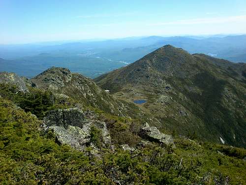

After descending from Mt. Adams, you have the “hamster wheel” portion of the Presidential Traverse: crossing the no-man’s-land down to Edmunds Col towards Mt. Jefferson. Though the elevation change is about 1000 feet, it occurs over a distance of ~1.8 miles until you start ascending the slopes of Mt. Jefferson. Consequently, you will find yourself walking on level portions of ground with the Jefferson seemingly not appearing any closer! From the col, you will ascend the slopes of Jefferson for ~.6 (total from Adams ~2.4-2.5 miles) miles until you reach its summit wither via it summit loop trail or Six Husbands Trail. Either way, soak up the views of Mt. Washington and the gaping chasm of the Great Gulf Wilderness and GG Headwall! Note: there are two big rock piles at the top of Jefferson. The summit is the one on the right, on which there is also a plaque dedicated to a fallen climber from a previous generation. Be careful! When we were there the summit proper was home to a wasp’s nest!


Descending Jefferson requires taking the loop trail for .3 miles until it rejoins the Gulfside Trail, at which point it is ~.75 miles until you reach the junction for the Mt. Clay summit loop trail.

Technically, Mt. Clay is not part of the Traverse; it does not even qualify as an independent peak because it is not high enough above the shoulder of Mt. Washington, though from the Mt. Jefferson side, it seems sizably taller than from the Washington side! We elected to take the Mt. Clay summit loop trail for peak bagging purposes (it is an extra .3 miles compared to staying on the Gulfside Trail).


- Mt. Clay Summit Loop: 1.2 miles across the summit of Clay until it rejoins the Gulfside Trail on the shoulder of Mt. Washington.
- Gulfside Trail: .9 miles until it meets with the terminus of the Mt. Clay summit loop trail.


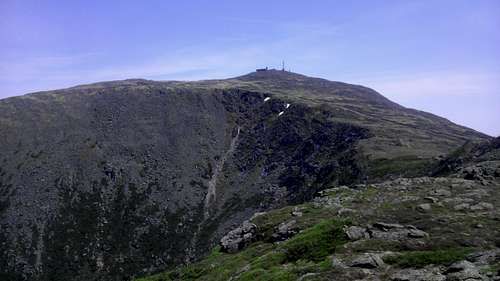
After Mt. Clay is the long slog up the summit cone of Washington. Staying on the Gulfside Trail should put you on the summit in about a mile. Cross the Cog Railway tracks and enjoy the fact that you are halfway through the Presidential Traverse (arguably the more physically demanding half in terms of elevation gain). Here would be a good time to reload on water (there’s a potable tap in the summit station) and eat lunch. Endure the crowds of tourists taking the Cog and the (evil) Auto Road to the summit and head south from the Washington summit. You will want to link up with Crawford Path (also part of the AT).
Descend the summit slopes of Mt. Washington for ~1.5 miles until you reach the AMC Lake of the Clouds Hut. From the hut, Crawford Path actually avoids the summit of the next Presidential peak, Mt. Monroe, by bypassing it to the south. You will want to take the Mt. Monroe summit loop trail, which will pass through the summit and rejoin Crawford Path after ~.7 miles.


Once past Monroe, you will probably have to dig deep for the energy to finish (we pushed for a 1-day traverse, and my buddy re-aggravated a knee injury descending the summit slopes of Washington… though he refused to give up!). From here it is a straight shot along Crawford Path for 1.5 miles until you hit the summit loop trail for Mt. Eisenhower. The good news is that Crawford Path often becomes a wide, convenient, well-marked path along this part of the Presidential Range. You will pass the triangular block summit of Mt. Franklin on your left. It is not required for the Presidential Traverse. Continue on to Eisenhower. The Eisenhower summit trail is a bit blockier than others, requiring switchbacks up a slope that appears much steeper when observing it from a distance while descending Monroe. Take the loop trail .4 miles to the summit (marked with a HUGE cairn) and follow it another .4 miles until it rejoins Crawford Path.


At this point, you might be up against the constraints of daylight, so make sure you know where your headlamp is for the descent after Pierce. Getting to Pierce is another long slog in and out of stunted pine trees and across exposed rock slabs. After ~1.2 miles you will hit the junction for the path to Mt. Pierce’s summit and Crawford Path (the descent). Getting to Mt. Pierce’s summit is easy: only ~.1-.15 miles, where you will hit a small clearing with a metal pole and the summit marker. Now you can fist pump knowing that you have hit all the Presidential Peaks! All that remains to officially complete the Presidential Traverse is a 3-mile slog down Crawford Path until you reach the AMC Highland Center in Crawford Notch. Now you are officially done!

Essential Gear
Necessary Equipment
Late Spring (i.e. mid-May)-Summer
-Sturdy hiking boots
-Merino wool socks
-Moisture-wicking/non-cotton base layer
-Moisture wicking pants (e.g. REI Sahara pants)
oYou can elect for shorts if the forecast is good in the summer. However, if it is black fly season, you might want to reconsider!
-Bomber insulating layer (e.g. fleece/Polartec)
-Rain/wind-proof shell jacket (can bring the rain pants, too, depending on the forecast)
-Day pack (30-ish liters)
-Trekking poles
-4 liters of water (3 in a Camelbak + 1 liter in a bottle)
-Breakfast and lunch
-Medikit
-Sunglasses and/or hat
-BUGSPRAY
-Sunscreen
-Headlamp, lighter, compass, map, phone/means of emergency communication etc.
Fall, Winter, Early Spring
Clothing:
-2 pairs of socks (merino wool/synthetic)
-Mountaineering boots
-Gaiters (e.g. OR gaiters)
-Synthetic base layer (e.g. Under Armour)
-Insulating layer (i.e. fleec/Polartec)
-Parka/synthetic pile jacket
-Rain/wind-proof shell jacket
-Rain/wind-proof shell pants or snowpants
-Long underwear
-2 pairs of glove liners
-1 pair of bomber insulated gloves
-Warm, fuzzy, insulating hat
Gear:
-Ice axe
-Crampons
-Snowshoes
-Trekking poles
-Multi-day backpack (≥65 liters)
-Bomber 4-season tent (International Mountain Equipment in North Conway rents them if you do not have a 4-season tent)
-Closed-cell sleeping pad
-Sleeping bag (rated at 0º or lower)
-1 stove with 3-4 days worth of fuel (you will probably need to melt a lot of snow…)
oIf you are going light: Jetboil Express or equivalent
oIf you want to boil larger quantities of water: Jetboil Helios or equivalent.
-Navigation equipment: compass, map, altimeter (optional), GPS (optional)
-Some paracord (for tying down tent corners)
-Headlamp
-Extra batteries
-Collapsible shovel (It will make you life significantly easier when digging out a tent site)
-Walkie-talkies, cell phones, or other emergency communication means.
-Medikit
-Optional: snow pickets: if you think you may be forced to camp close to or in the alpine zone (has to be on at least 2 feet of snow and 200 feet away from any water source. You also cannot camp in the Cutler River drainage on the east side of Mt. Washington).
Food (and Drink):
-Plenty of GORP
-Energy gels and bars
-Breakfasts (Oatmeal and protein powder is super light and easy to make)
-Lunch in the form of snacks (GORP, granola bars, energy gels, etc)
-Dinners (Mountain House and other dehydrated meals are super convenient; dehydrated soup mixes can work well as an appetizer, too!)
-3 or 4 liter Camelbak/Platypus water pack + 1 or 2 one-liter Nalgenes
-To be stored in the car: A cold beer as a reward for either finishing the Traverse, or just plain coming home safe…
When to Climb
The Presidential Traverse can be attempted year ‘round. The highest chances of success would be late spring into summer, and that attempt would qualify more as a hike than mountaineering. Fall into winter and even early spring will make the Traverse more of a mountaineering environment.
Some considerations for a winter attempt:
A friend and I made an attempt in the dead of winter (early January). Be prepared for cold temperatures, high winds, and ridiculous windchills! Your pack will also be about 20+ lbs. heavier with extra equipment (see above). Check the forecast and plan on spending 3-4 days along the range crest for an average party. 2 days would probably be required for a strong party. Do NOT plan on a 1-day traverse in the winter unless you are in Olympic shape!
NB: Be ready to face very adverse or quickly deteriorating conditions in winter. Smart decision making is essential. If you have any doubts, play the conservative card! The Presidential Range has been around for over 300 million years! It will certainly be there next month or next season!
Most people will take the Valley Way Trail in winter and pitch a tent at the Valley Way tent site. The RMC Gray Knob Hut might also be open in the winter, too.
NB: All of the AMC Huts above the treeline will be closed in winter. The summit station on Mt. Washington is closed to climbers unless in true emergency situations. The Lake of the Clouds Hut does have an emergency bivouac room (very bare and uninviting... there's a reason why it's called "The Dungeon."), but again, it is only allowed in the case of a true emergency! Also, LotC hut sits on the col separating Washington from Monroe. Any storm conditions coming into that area of the range will be amplified as they are funneled into/across the col!


Red Tape
In the winter, you do not have to register for doing the Presidential Traverse, but it is highly recommended if you do so. The easiest thing to do would be to sign in at the Pinkham Notch Center at the base of Mt. Washington. There is a climber’s log in the Center (don’t forget to sign out after you finish!). You will have to pass by Pinkham Notch, anyways, if you approach the Appalachia trailhead from North Conway and Gorham.
For camping: Camping above the treeline is prohibited during the on-season. Camping can only be done at approved tent sites (marked on AMC maps). During the winter, camping is allowed above the treeline only on 2+ feet of snow and at least 200 ft. away from any water source. Camping is also prohibited at all times on the Cutler River drainage area on the east side of Mt. Washington.
External Links
Mt. Washington Observatory: www.mountwashington.org (has weather and condition reports)
About the Whites: www.hikethewhites.com
NH Parks and Recreation: www.nhparks.state.us
White Mountain National Forest Campgrounds: http://www.fs.fed.us/r9/forests/white_mountain/recreation/camping/