-
 38414 Hits
-
 75.08% Score
-
 6 Votes
|
|
Route |
|---|---|
|
|
42.63360°N / 73.14056°W |
|
|
Hiking |
|
|
Spring, Summer, Fall, Winter |
|
|
Half a day |
|
|
Strenuous |
|
|
Overview
The Thunderbolt Trail is the shortest and steepest route to the summit of Mt. Greylock. The trail is mainly composed of steep mountain meadows with great views to the surrounding Berkshires Region. The trail offers backcountry skiing in the winter and was originally cut by the CCC. The United States Eastern Alpine Ski Championships were held on the Thunderbolt Trail in 1936.
Getting There
Travel south on MA Route 8 from North Adams. Once through Adams (a different town than North Adams), turn to the right onto Friends Road. Friends Road will become West Road. After 1.5 miles, turn right onto Thiel Road. Continue on Thiel Road to find the trailhead. Parking is available at the intersection with Gould Road (plowed) or farther down Theil Road at the actual trailhead (unplowed, 4WD required).
Route Description
From the trailhead, the Thunderbolt Trail ascends 2275 vertical feet in 2 miles. The trail starts west, heading up the base of the mountain, and crossing the original ski trail on hiker's right. After a half mile, the trail turns to the north-west and heads steeply up towards the Mt. Greylock summit ridge. After 1.5 miles of hiking, the Thunderbolt Trail reaches the summit ridge and intersects with the Appalachian Trail. Hikers should follow the AT .5 miles southwest (turn left) to the summit of Mt. Greylock. On the route to the summit, the AT passes by a stone shelter/warming hut and crosses the summit road (closed, along with Bascomb Lodge, until 2009).
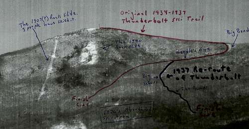 Map of the Thunderbolt Trail, courtesy of the New England Lost Ski Areas Project.
Essential Gear
During the winter, when the trail is snow covered, snow shoes are helpful, but not required. The trail is usually well packed. During the summer, nothing more is required than hiking boots.
External Links
North Adams Forecast - Weather.com
Map of the Winter Trails on Mt. Greylock.
hightinerary - May 20, 2016 9:06 am - Hasn't voted
Thiel RoadThiel Road is closed; the hike starts at the barricade. Thus, the first five minutes of the route are on pavement.