
-
 2183 Hits
-
 83.1% Score
-
 16 Votes
|
|
Mountain/Rock |
|---|---|
|
|
29.88350°N / 9.10034°W |
|
|
Anti-Atlas, Jebel El Kest |
|
|
Trad Climbing |
|
|
Spring, Summer, Fall, Winter |
|
|
4265 ft / 1300 m |
|
|
Overview
The Turtle
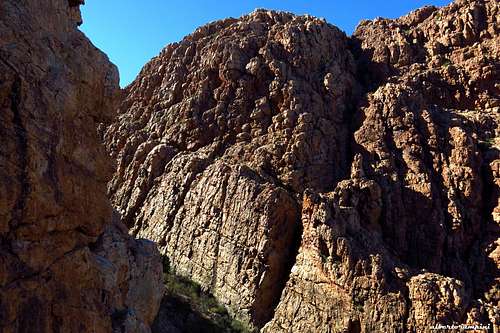
While driving from the Kasbah Tizourgane to the village of Ida Ougnidif, on the Northern side of the Jebel El Kest Massif, before reach the village you will meet a road on the right entering a valley South/North oriented and located at the base of a long succession of crags: it's the Northern side of the Jebel Taskra Massif. This broad escarpment, named Tizi N'Takoucht Escarpment, is located North-West of Ida Ougnidif and has plenty to offer to the climbers in reason of the high quality quartzite and the convenience of the approaches, mainly brief. In fact many crags are close enough to the road and some are really impressive, such as the superb Assldrar Thumb, an icon in the whole region. The Thumb is a full 300 m high dôme with challenging big routes, just in front of the tiny village of Assldrar, located on the Eastern end of the Tizi N'Takoucht Escarpment. Starting from Assldrar it's possible to climb some others impressive rock faces, as The Turtle and Antelope Buttress, both located on the left end of the rocky circus surrounding the village and offering some very interesting routes.
The Turtle East wall seen from Antelope Buttress |
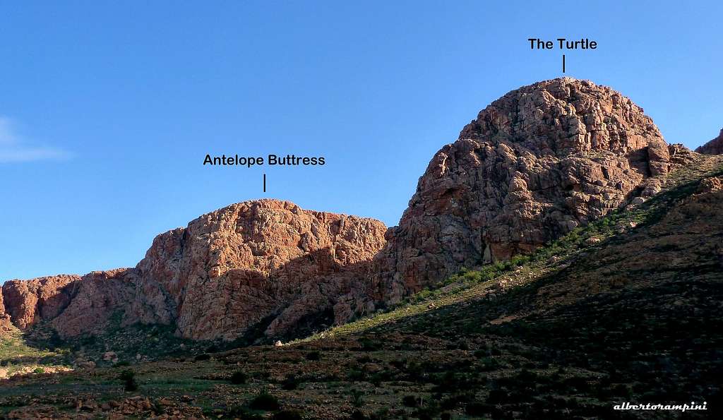
Antelope Buttress and The Turtle seen from Assldrar |
A big dome with a rounded shape, looking similar to a turtle-shell, lies between Antelope Buttress on the left and Tramline Slabs on the right, it's "The Turtle".
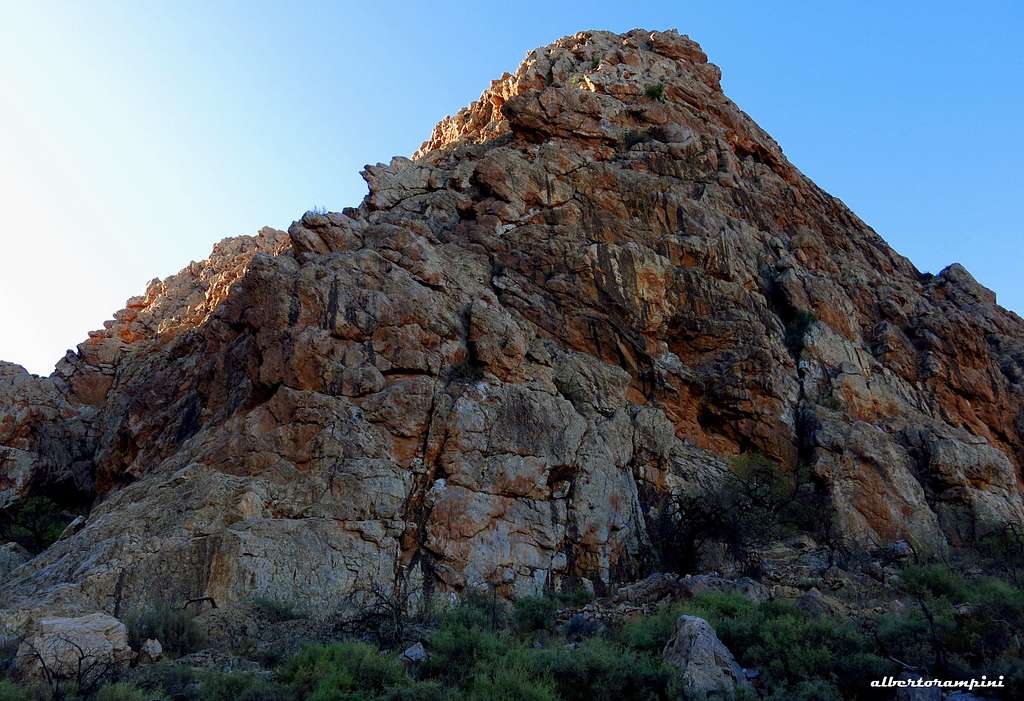
"The Turtle" North wall
Getting There
The Jebel El Kest range can be conveniently approached both from Agadir and from Marrakech; several international flights run to Marrakech and Agadir airports. The best choice is hire a car (in the Airports there are many Car Hire Agencies).
- From Marrakech the road to Tafraoute involves a trip of 400 Kms and takes nowadays about 5 hours via the new Motor-way connecting Marrakech to Agadir, then following a busy road via Inezgane (near Agadir), Biougra and Ait Baha; alternatively you can follow the road via Asni, through the High Atlas range, a trip along a narrow mountain road inside a charming and scenic landscape, and Taroudant (it takes at least 7-8 hours).
- From Agadir the travel is shorter (you can drive to Tafraoute in 2 hours on a 170 kms good road), but the flights choice is more restricted.
Access to the Antelope Buttress
The starting point to climb Antelope Buttress is the tiny village of Assldrar below the Tizi N'Takoucht Escarpment in the Northern side of Taskra North.

The nearest village is Ida Ougnidif located on the Northern side of the Jebel El Kest area. A road (signpost) starts rightwards near Ida Ougnidif - between the Kasbah Tizourgane and Ida Ougnidif - and runs below the escarpments from East to West. Leave this road turning left once arrived at the village of Ayoufis and follow the road to Assldrar. Park the car with care near a T Junction.

|

|
The Turtle East Face - "Metamorphosis"
The Turtle, "Metamorphosis" - British scale
Summit altitude: m 1300
Difficulty: HVS, 5b (British alphanumerical scale)
Equipment: none, the conformation of quartzite allows conveniently to put down protections along the pitches and on the stops
Route length: 240 m
Exposure: East
First ascent: Alberto Rampini and Silvia Mazzani 2013, November 4th Starting point: village of Assldrar
A long fine route on excellent rock. Lonely situation, but brief approach and descent.

|

|
Approach - The East Face of "The Turtle", located just in front of the route “The Unbreakable” on Antelope Buttress, is hidden and not visible from Assldrar. From Assldrar cross the river bed, then follow a very good path rising leftward in the direction of the leftmost crags of the rocky circus. The path skirts "The Turtle" North wall and reachs a large vegetated slope between Antelope Buttress to the left and "The Turtle" to the right. Walk briefly up the slope, getting quickly a huge black chimney on the right hand, separating the East Face of The Turtle in two well separate sectors. The starting point of the route is below a ridge immediately left of huge black chimney - 40 min from Assldrar.
L1 – 25 mt, 4a. Just on the ridge immediately to the left of the huge chimney climb up little walls and a line of corners. Belay under an orange roof.
L2 – 37 mt, 5b. Traverse 4 meters left below the roof, then up directly on a hard chimney and a sequence of walls and grooves, reaching a shoulder. Belay on a block.
L3 – 32 mt, 4a. Climb in the middle the black striped spur over the shoulder to a stance under huge blocks.

|

|
L4 – 50 mt, 4c. Climb again the spur with some difficult moves to a terrace. A short slab to a stance under a red wall cut by a corner
L5 – 45 mt, 5a. Little overhang and a wall to enter the beautiful corner. Climb the corner, then a chimney with a jammed stone to a terrace
L6 – 50 mt, III. Climb easy little steps to the summit.

|

|
Descent - from the summit head to South, reach a col with little palms, then turn to left and scramble toward Antelope Buttress to gain another col between The Turtle and Antelope. Walk down the gully starting from the col, getting the base of the route, then Assldrar (50 min). Very good trail.
The Turtle North Ridge - "Turtles on the run"
The Turtle, "Turtles on the run" - British scale

Summit altitude: m 1300
Difficulty: HVS, 5b (British alphanumerical scale)
Equipment: none, the conformation of quartzite allows conveniently to put down protections along the pitches and on the stops
Route length: 240 m
Exposure: North
First ascent: Alberto Rampini and Silvia Mazzani 2013, November 8th Starting point: village of Assldrar
An adventurous fine line with five superlative pitches. Solitary situation, but brief approach and descent. The Turtle has two summits, separated by a vegetated gap; this route climbs the northern summit.

|

|
Approach - 20 min from Assldrar. Starting point on the right (10 meters) of the lower point of the North Ridge (the left ridge looking from the village). Cairn at the base.
L1 – 28 m, 5a. An excellent pitch on a grey and orange wall with immaculate rock. Climb the grey wall, then climb slanting right a little overhang. Belay on blocks (sling).
L2 – 50 m, 4a. After a short groove, cross a terrace and climb a spur to a stance on a jammed block
L3 – 30 m, 4a. Cross a terrace then climb a wall and belay under an orange roof
L4 – 20 m, 4c. Traverse left, climb a groove then a crack
L5 – 40 m, 4a. Up the central spur, then climb the second one on the left. Belay under two orange pinnacles
L6 – 30 m, 4c. Traverse left and climb a hidden perfect corner, then traverse to the main wall of the right pinnacle, climb it and belay on a block (sling)
L7 – 55 m, 5a. Directly up the red wall, then a spur to a large terrace
L8 – 45 m, 4b. Up the orange ridge on beautiful carved rock
L9 – 35 m, 4a. Another fine ridge on the left of the stance.
|
|

|
Descent - Walk down to the gully between the two summits of the Turtle and up shortly to the Southern summit. From here, same descent as described in the route Metamorphosis. It's possible another descent via the col between The Turtle and Tramline Slabs, shorter but not recommended (thick vegetation).
Essential gear
Double ropes and usual climbing gear (helmet, harness, quickdraws, slings, belay devices). Routes are not equipped, so bring a complete set of friends and nuts.
Red Tape
Climbing doesn’t suffer official and established restrictions, but however climbers are urged to respect the ethics of the pioneers, in order to preserve in the area the original adventurous trad climbing. In all the quartzite routes to date, no bolts and a few pitons have been fixed or used. In fact, the quarzite provides ideal cracks to place friends and nuts.
When to Climb

The best seasons to climb are fall (from the end of october) and spring, till april, when the weather is mainly fine and the temperature is pleasant. Late in the spring and in summer the temperature rises up dramaticaly, and climbing is virtually impossibile. Winter (december to february) is traditionally the wet season and rain, cold and even snow, on the highest peaks, sometimes may be a problem. Nevertheless, you can find often pleasant temperature also in winter during the day, though the evening and the night can be quite chilly.
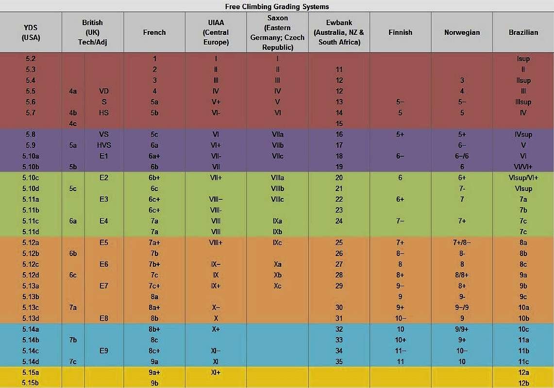
Rock climbing scales
Grades are expressed in the alpha-numerical British Scale, as usual in the the Jebel El Kest region. See below a helpful conversion diagram:
Nature

The landscape is marked by the shape of the Argan trees, producing plenty of berries, which precious oil finds a large use in cooking and beauty culture, and by the palms in the oasis. We can find some other spiky vegetation as cactus, prickly pears and the beautiful but unpleasant Euphorbia everywhere along the approach tracks and on many climbing routes; the Euphorbia is growing mainly on the slopes and on the steep walls facing South and it must be avoided because of its irritant white milk. The area counts many species of mammals, like gazelles, antelopes, wild boars, the native grey squirrels named "sib-sib" and many kind of birds. Various kind of poisonous snakes and scorpions have been reported, but it’s rare to meet them during late fall and winter months.

|

|
Where to stay
– The closest place to Tizi N'Takoucht Escarpment is the charming and traditional The Kasbah Tizourgane, nearby Ida Ougnidif.
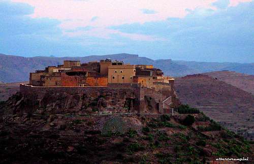
The Kasbah Tizourgane |
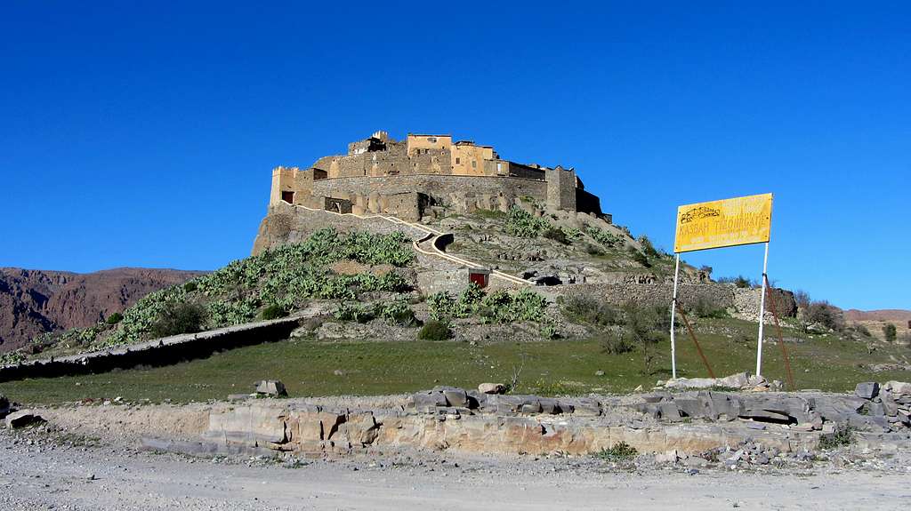
The Kasbah Tizourgane - ph. Bald Eagle |
Geology and rock
The most common rock is a pre-Cambrian quartzite, which quality is often perfect; its plenty of cracks allows a pleasant and sure climbing, with many opportunities of good natural protections.
Guidebooks and maps
North Side
"Tafraout - Rock Climbing in Morocco's Anti-Atlas" Vol II - The North Side of Jebel El Kest and Jebel Taskra by Steve Broadbent, Oxford Alpine Club 2013
“Morocco Rock – Jebel el Kest & Taskra North, 1000 Rock Climbs in the Anti-Atlas” by Emma Alsford and Paul Donnithorne, Crack Addicts 2012
“Moroccan Anti-Atlas North” by Steve Broadbent – Oxford Alpine Club 2010
 |
 |
 |