
-
 1878 Hits
-
 80.49% Score
-
 12 Votes
|
|
Mountain/Rock |
|---|---|
|
|
46.65186°N / 13.53738°E |
|
|
Download GPX » View Route on Map |
|
|
Hiking, Skiing |
|
|
Spring, Summer, Fall, Winter |
|
|
6207 ft / 1892 m |
|
|
Overview
Name: In German the mountain is named Tschekelnock. As in the area of Gail/Zilja and Drau/Drava also Slovenian people are living, let's mention also their name of this mountain: Čegla gora. Despite quite modest altitude, Tschekelnock is quite an important and often visited summit. It rises in the eastern part of Gailtal Alps, just above the Windische Höhe / Ovršje pass. In its southern slopes, on the altitude between 1460 m to 1700 m, once there was a mine of led and zinc. It saw its highest prosperity in the middle of 19th century, today it is closed. Tschekelnock is today mostly visited by hikers. As mountain roads are reaching high below its summit, it is also a convenient goal of mountain bikers and tour skiers. For harder climbing its rocks are not convenient.

Summit Views
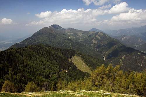
Standing quite remotely from other higher mountains, and also a bit indented towards the north, Tschekelnock is a good lookout mountain. The most attractive parts of panorama are the views on the nearby Graslitzen, on the group of Latschur, towards the east on Dobrač massif and on Carnic Alps across the valley of Gail.
Getting There

The most convenient trailhead is Windische Höhe road pass, 1110 m. By car it can be quickly reached from Gail valley, but also from the north, from the valley of river Drau. From the road pass mountain roads are ascending towards the summit of Tschekelnock. They don't look to be closed for public traffic (2016). In any case they are very convenient for mountain biking. The highest point of the road is on Hadersdorfer Alm, 1709 m. From there you have only 30 minutes to the top. 
On Hadersdorfer Alm there is a small chapel, devoted to the builders of mountain roads - those on the southern side of the mountain were connected with the northern ones in 1995. So, it looks that you could reach there also from the northern side, from the road, which reaches Weissen See from the east. We deter from that road at Plachhäuser, then drive by the valley towards the SW (on Patternioner Alm) and further towards the south on Köstendorfer Alm. The roads in this area are very branched and it's also not sure that all of them are opened for public traffic. We were driving from Windische Höhe pass by car by the road, which has on 1280 m an important branching. The correct branch would be the right one (towards the north), but we took the weaker left branch, and had to park already on 1340 m, where right up from the road the marked path deters. |
Summit Ascents
1. Tscheckelnock from Windische Höhe
This is an easy route (on the Swiss Hiking Scale would be graded T2). If we go on top just from the road pass, we need for ascent 2 h 30 min. The route goes mostly through the woods, partly using also mountain roads. On some places nice views are opening, so the ascent is not boring. The summit ridge is short, but nice and panoramic. Description. From the road pass the marked path goes first over the meadows towards the north, then through the woods towards the northwest. A few times it crosses mountain roads. On the altitude of 1340 m the path deters from the road again towards the north, reaches through the woods the upper road on the turn on 1440 m, and continues left again through the woods. Next time it reaches the road again on 1580 m. One more shortcut brings us on the road below Hadersdorfer Alm - we have only a few more minutes till there.


From the alpine meadow we continue by the hut and further towards the east on a distinct, forrested mountain ridge. That one is waving over some distance towards the northeast. Later some nice clearings on the ridge open, but really panoramic the ridge becomes just below the summit. That part of the route is steeper and requires a bit of additional attention (still easy). See the route GPX profile here!
2. Tschekelnock from Köstendorfer Alm.
This nice and quite frequented alpine meadow lies close to the main ridge of Gailtal Alps. On the page of Graslitzen (East route) you can read how it can be reached from the valley of Gail. From Köstendorfer Alm the main Gailtal Alps long distance hike (Gailtaler Höhenweg) goes towards the east on Windische Höhe road pass. That's the marked trail we must follow to reach Tschekelnock from the west. The crossing of trails is at Geißrückenkreuz.

Description. From Geißrückenkreuz, 1531 m we go towards the east, first across the lower part of Köstendorfer Alm meadow, then we slightly ascend on Gaisrücken. This part of the trail is nice and panoramic, we walk all the time near the high edge above Gail valley. Gaisrücken is steep and rugged towards the south, above wild ravines we can admire a few picturesque rock towers. From the other side a mountain road reaches the edge and close to it there are some weekend huts and the nice Georgi Chapel. Over a few bumps the trail goes a bit up and down and finally descends on the lowest point, 1416 m. Now a bit steeper hike up is ahead of us. It still goes through the woods close to the edge, the direction is east. After good 15 min of ascent we reach the crossroads on 1505 m. From the left a narrow mountain road reaches there, goes over the ridge, descends towards the south and ends there. Continuing by the Gailtaler Höhenweg on Windische Höhe road pass would mean going down by the road a bit and then through the woods quite a way down towards the south. On 1360 m the trail hits the lower road, which the marks are then following towards the east, and, as it was already described, down on the road pass. Towards the summit of Tschekelnock, however we must deter on the crossroads 1505 m left up the slope (the trail is well marked). Another 150 m of ascent are ahead of us, the trail goes all the time towards the northeast. The upper road we reach just below Hadersdorfer Alm, then we continue on top of Tschekelnock, as it was described at route #1.
Sieben Brünn

South below Gaisrücken, just above Köstendorf village (above the valley of Gail), there is a nice biotop, where in a sunny side valley water sources from several sides join. A part of the broad, flat valley is a marsh, the place is well known also by its specific flora. Sieben Brünn can be reached through Köstendorf village (inscription plates).
When to Ascend?

On Tschekelnock we can ascend in any season. In winter time the roads are of course not cleaned, so appropriate gear is needed (skis or snowshoes). If snow is hard or even icy, for the summit ridge ice pick and crampons are needed. In good conditions skiing from the very summit is possible.
Mountain Huts
In the vicinity of Tschekelnock there are no official mountain huts, but on alpine meadows and on Windische Höhe there are many private huts.
Your Help Is Needed
If you have it, please contribute the following information:
- Do you have winter experience with Tschekelnock?
- Have you done the ascent with skis?
- Any historical data or interesting things about the place?