
-
 3657 Hits
-
 79.78% Score
-
 11 Votes
|
|
Mountain/Rock |
|---|---|
|
|
46.71872°N / 12.91341°E |
|
|
Hiking, Skiing |
|
|
Spring, Summer, Fall, Winter |
|
|
6398 ft / 1950 m |
|
|
Overview
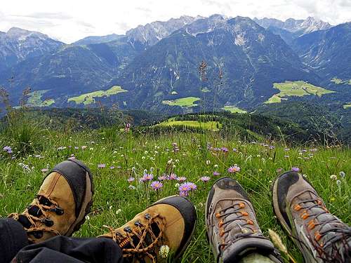 The scene from Mussenhöhe
Introduction
In the southern Austria, in Gailtal Alps / Ziljske Alpe, there is a mountain ridge, famous by its unprecedented flora and fauna. Its abundance and variety is enabled by the change of geological structure of those mountains, which would otherwise be nothing so very special. The most beautiful part of the ridge is its grassy area, aproximately above 1500 m of altitude. Once there were pastures, today the area is a protected natural parc.
The ridge starts on the east on Gailberg Sattel, which divides Lienz Dolomites on the west from the rest of Gailtal Alps on the east. From Gailberg Sattel the ridge towards the west is first covered with woods and only on the first higher summit, called Guck, 1773 m, it becomes grassy. Further towards the west there are the following rounded, grassy bumps on the ridge: Point 1855 m, Mussenhöhe, 1950 m, which is the actual top of the area and more towards the northwest there is the summit of Mukulin, 2038 m, which is sometimes also considered as part of Auf der Mussen area. North of Mukulin rises the even higher Schatzbühel, 2090 m, which is not any more considered as part of Auf der Mussen. The northern slopes of the ridge are falling steeply into the wild, heavilly eroded Gailbergbach valley. This big wound in the mountaneous area is a geological specialty. Some picturesque towers are still resisting on the slopes, otherwise till the main ridge the whole valley is barren. From that side no useful path ascends the main ridge of Auf der Mussen.
Etymology
In German the word Muße means the time of well being, leisure. So, Auf der Mussen means going on a nice place and spending free time there.
What To Do There?
Auf der Mussen is first of all a great hiking area. Many visitors do quite long hikes from the valleys, but shorter round hikes only in the upper area are also possible. For those who enjoy long distance treks, the Gailtaler Höhenweg (Gailtal High Route) crosses the whole ridge. In winter the grassy ridge is also popular for tour skiing. Lower parts of tours go mostly by forrest roads. Finally, you can also visit the area by a mountain bike. That would be helpful for the forrested parts of tours, but above, on the meadows, biking would be a heavy sinn.
 The scene from Mussenhöhe
The Natural Parc
 Gentiana lutea
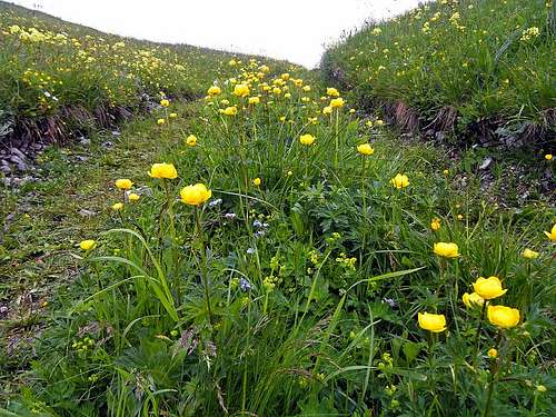
On the southern slopes of the Auf der Mussen ridge some 500 different species of flowers are blossoming, of which more than 280 so-called high plants. The most famous among them is the white queen paradise lily. In addition to soil diversity this flora richness can be attributed also to favourable climatic factors: south oriented slopes, relatively warm climate and not least the position just opposite the relatively deep incision of Plöcken Pass on the south. In the evolvement of the area also humans had a big stake. Hundreds years ago the woods on the ridge were cleared and the pastures were used for traditional farming. Not surprisingly, rich flora is being accompanied by some 1000 animal species, including 670 different butterflies and more than 100 spiders, among them some very rare species.
 Paradise lily Paradise lily |  Lathyrus occidentalis Lathyrus occidentalis |  Orchids Orchids |
Panoramas
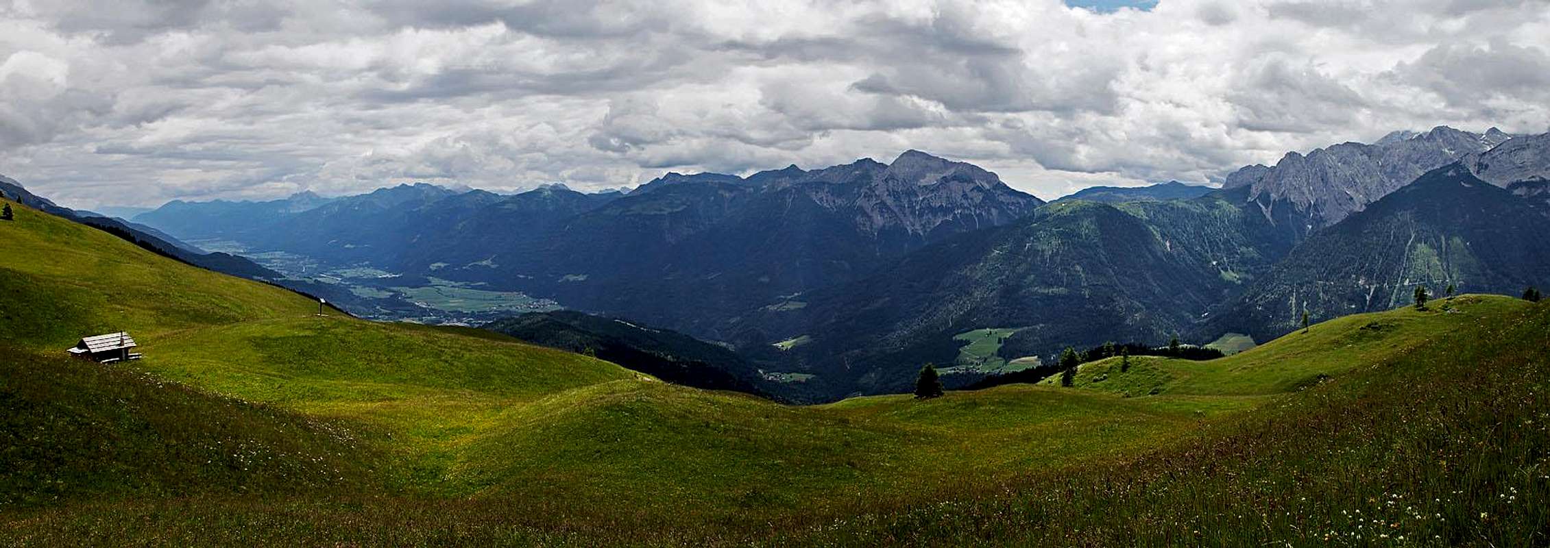
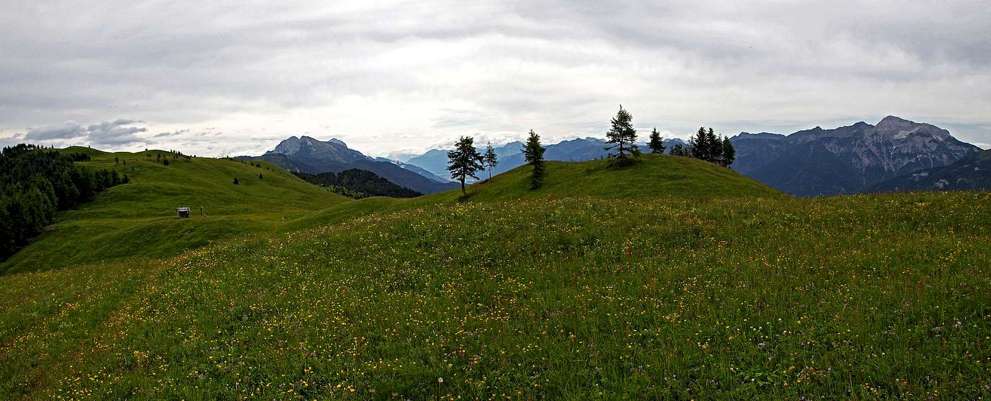
 Carnic Alps from Mussenhöhe
Despite its relative low altitude, Auf der Mussen is remote enough from other mountain groups to offer very nice vistas. Very impressive is the long chain of Carnic Alps on the south, with its highest part just opposite of us. On the west, a nice parade of rugged, much higher Lienz Dolomites rises. On the north, across Drau valley, there is the Kreuzeck gruop, but also some other distinct summits of Hohe Tauern can be seen. And towards the east the views along the Gailtal Alps and the two bordering valleys are mostly opened.
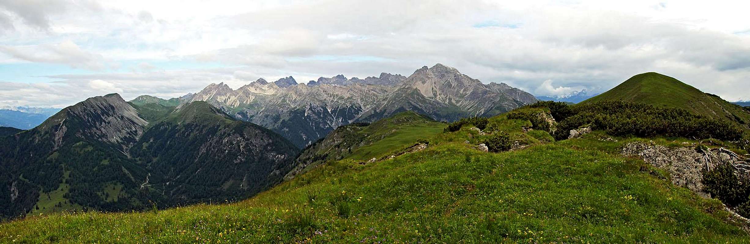 Lienz Dolomites from the summit of Mukulin
Getting There
 Flower cart road
If visiting the area on a one day tour, we can use the trailheads on the road through Gail valley and the one on the east, on Gailberg Sattel. 1. Gailberg Sattel, 981 m. Reachable by the road, connecting Kötschach-Mauthen in Gail valley and Oberdrauburg in Drau valley. 2. Strajach, 970 m. Reachable from Kötschach-Mauthen by the Gail valley road.
 Zum Löwen inn, St. Jakob
3. St. Jakob, 984 m. Reachable from Kötschach-Mauthen by the Gail valley road. 4. End of the road from St. Jakob, cca 1500 m. The road is payable, 7 EUR (2015), you get the key in the Zum Löwen inn. 5. Podlanig, 973 m. Reachable from Kötschach-Mauthen by the Gail valley road. 6. End of the road at Jägerhütte, 1562 m. The road is payable. Reachable from Podlanig/Strenge, driving N and then NE. 7. Kornat, 1033 m. Reachable from Kötschach-Mauthen by the Gail valley road till Birnbaum and then by the mountain road towards the north. Other trailheads are more remote.
Hikes In the Area
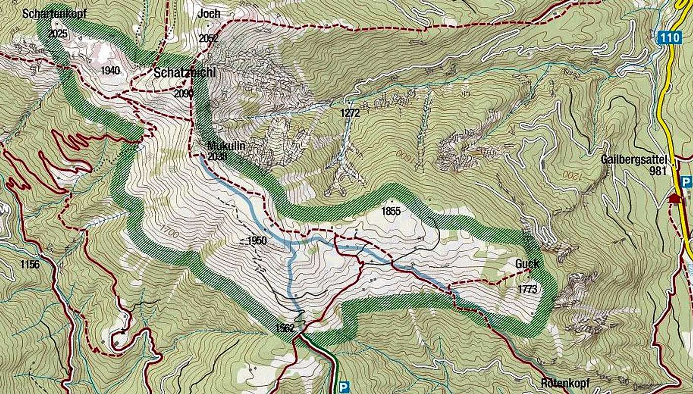
From Gailbergsattel, 981 m
On the saddle you catch the mountain road, by which also the marked path No. 226 goes towards the SW. Soon it turns westwards and in several steeper turns ascends on the Rötenkreuz crossroads, 1290 m. From there we continue right, ascending gently in the NW direction. Below the dome of Guck we get out of woods and continue in the same direction along the main ridge. Some 3 h 30 min to the summit of Mukulin.
From Strajach, 970 m
By the mountain road and path No. 226 we go northwards into the valley of Rötenbach and eastwards out and up on the Rötenkreuz crossroads. Then left on the main ridge.
From St. Jakob
If we start in the village, we go by the mountain road and the path No. 225 (takes some shortcuts) towards the north. After some 6 km (1 h 30 min), on 1500 m, there is a big parking place. Soon above it you are already out of the woods. You best ascend by a cart road in the NE direction and then turn slowly left on the main ridge. Great scenes on those meadows! From the cross on top of those meadows the marked path goes towards the W and NW on Mussenhöhe and Mukulin. From the parking place less than 2 h.
From Podlanig, 973 m
You can either start hiking there or again pay the mountain road till Jägerhütte, 1562 m. That's already on the lower part of the upper meadows - joining the approach from St. Jakob. From Podlanig and also from Kornat nice is also the tour, which goes all the time northwards, along the Podlaniggraben. In the upper part you can then do a round tour, including Schatzbüchel, Mukulin and Auf der Mussen. Some 7 h altogether. All the above tours are easy (T1/T2 by the Swiss Hiking Scale).
 Auf der Mussen
Red Tape
The ridge area (see the map above) is protected as a natural parc.
When To Ascend?
| No doubt that you should visit Auf der Mussen almost exclusively in the times of mountain spring (exception is a ski tour, of corse). That is from June till mid July, a bit depending on how warm the previous winter was. In a few weeks the picture of blossoming flowers can change a lot. If you are not from far away, come several times to experience the difference. Finally, a clear autumn day visit is also not forbidden. |