
|
|
Mountain/Rock |
|---|---|
|
|
39.11230°N / 120.2319°W |
|
|
Placer |
|
|
Hiking, Skiing |
|
|
Spring, Summer, Fall, Winter |
|
|
8878 ft / 2706 m |
|
|
Overview
Twin Peaks is located on the border of the Granite Chief Wilderness on the west shore of Lake Tahoe, just south of Alpine Meadows ski area. Its close proximity to Highway 89 allows for year-round access. The peak provides fantastic views of the Desolation Wilderness, Lake Tahoe, and the Granite Chief Wilderness. The great views from the summit can be had for minimal time and effort. The east summit is the high point.During the summer, the summit can be reached via class 1 terrain from Blackwood Canyon Road or Alpine Meadows ski area. Because Blackwood Canyon road is not plowed and most ski areas do not take kindly to trespassing, winter ascents must begin at the Blackwood Canyon Sno-Park on Highway 89.
The peak can easily be climbed in summer or winter in a day. Summer back country camping opportunities in the area are limited, but it would serve as a good introduction to snow camping.
Twin Peaks is on the TAHOE OGUL PEAK LIST.
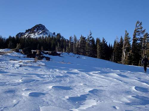
Twin Peaks East Summit
Getting There
| Trailhead | Route | Difficulty | Elevation Gain | One Way Distance |
|---|---|---|---|---|
| Alpine Meadows | Trail | Class 1 | 2280ft | 4.6 miles |
| Barker Pass | Trail | Class 1 | 2250 ft | 5.5 miles |
| Blackwood Canyon Sno-Park | Cross Country | Class 1 | 2590 ft | 5.4 miles |
| Ward Creek | Trail | Class 1 | 2500 ft | 6.2 miles |
ALPINE MEADOWS (39.146° N, 120.222° W): Located on the south side of Gstaad Road, approximately 6.9 miles west of Highway 89. Follow the trail south for 3.8. miles until on top of the ridge connecting Twin Peaks and Stanford Rock. The summit is 0.8 miles west and 800 vertical feet from here.
BARKER PASS (39.072° N, 120.231° W): Located on the north side of Barker Pass Road, approximately 7.1 miles west of Highway 89. Follow the trail north for 4.2 miles until the summit comes into view. The summit is 0.3 miles east and 400 vertical feet from here.
BLACKWOOD CANYON SNO-PARK (39.113° N, 120.158° W): Located on the west side of Highway 89, approximately 4.8 miles south of Tahoe City. Follow Blackwood Canyon Road west for 2.3 miles to where it joins the Blackwood Canyon Road trail.
WARD CREEK (39.136° N, 120.180° W): Located on Ward Creek Blvd, approximately 1.3 miles west of Highway 89. Follow the trail west for 5.4 miles until until on top of the ridge connecting Twin Peaks and Stanford Rock. The summit is 0.8 miles west and 800 vertical feet from here.
Summit Ridge
Red Tape
The eastern approach to Twins Peaks is regulated by the LAKE TAHOE BASIN MANAGEMENT UNIT and thus is free from most of the regulations that inhibit wilderness areas. No permit is required for day hiking. Parking on Blackwood Canyon and at Alpine Meadows is free. Winter access from Alpine Meadows is subject to dirty looks and rude comments from the over zealous ski patrol. During the winter parking at the Blackwood Canyon Sno-Park requires a SNO-PARK PASS.Camping
Developed campgrounds can be found at Meeks Bay, D.L. Bliss State Park, Emerald Bay State Park, and Bayview. Fees and facilites vary.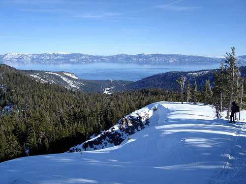
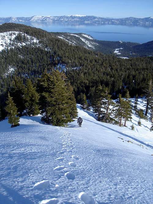
View of Lake Tahoe
When To Climb
Highway 89 is open year around allowing all season access to peak. While the Blackwood Canyon Road is not plowed in the winter, the Sno-Park adjacent to Highway 89 is. The peak is generally snow free from July through September. The area is popular with hikers, snowshoers, skiers, snowmobiles, and tourist: do not expect solitude in any season.Mountain Conditions
Lake Tahoe is subject to a variety of weather conditions, including heavy snowfall in the winter. Weather forcast can be found HERE.The avalanche advisory can be found HERE.
fedak - Jun 23, 2009 1:46 am - Hasn't voted
Ward Creek/Barker PassMight want to add the two TRT trailheads- Ward Creek (6.2mi) and Barker Pass (5.5mi)
BCL - Jul 5, 2009 11:28 am - Hasn't voted
Re: Ward Creek/Barker PassDone, thanks.
fedak - Jul 8, 2009 2:48 am - Hasn't voted
Re: Ward Creek/Barker PassProbably should also note that the summit is a class 2/3 talus scramble and that the easternmost of the Twins is the highpoint.
hgrapid - Jun 17, 2012 11:32 am - Hasn't voted
Tahoe Rim Trail out and back?I think your coordinates for Ward Creek refer to the starting point at FS Road 15N3S, not the Tahoe Rim Trail starting point, which is an out and back and a little further up. The TRT starts at 39.140402, -120.191732