Catwalk - Elkhorn Mountain
If you're looking for alpine climbing on Vancouver Island the Elk River valley is certainly the place to go. Well not the valley itself but the peaks ringing the upper valley are amongst the highest on the island. It's a role call of the Island's finest: Mt Colonel Foster, Rambler Peak, King's Peak and Elkhorn making up the 'A' list.
Needless to say as an avid Island climber I've paid a few visits to the Elk River over the years, I'm guessing somewhere between 75 and 100 treks up the vaunted Elk River trail, but heck! who's counting? !
So it was no surprise to find myself on my fourth trip up the Elk River trail of the year in early July with Hunter Lee, headed to… Elkhorn.
Hunter and I had done a trip a few weeks earlier along the ridge to the north east of Elkhorn. It was more of a hiking, exploratory mountaineering foray than a climbing trip. But we saw a great deal of the north east of Elkhorn on that trip and that planted a seed to make another trip closer onto Elkhorn and maybe find something to climb.
Onward up the Elk River trail… our loose plan was to head to the south col of Elkhorn and snoop around the south east cirque and the east ridge. We brought ropes and a small alpine rack so we had something moderately technical in mind but no definite plan.
The approach to the Elkhorn south col and its neighbour to the south, the confusingly and ignobly titled Elkhorn South is via a rough route up the west flanks of the massif from the 'gravel flats' camp site about 9 km up the ERT. An old log provides an ideal crossing over the Elk River that was swollen still with the spring thaw. I say 'old' but the truth is I remember the year that the log was undercut by the river and fell across it. Then it was fresh with bark and a solid root ball. Fast forward a 'few' years and the root matt is getting a bit soft and the log is bleached and crawling with carpenter ants… Nevertheless it conveyed us across the rushing water in style.

On the east side of the Elk River we met with a decidedly un-stylish wall of slide alder. A few flags weaved us through the slide alder and across a couple of small streams and into the old growth amongst a pile of moss covered boulders. Hunter and I figured lunch was in order and we stopped for a break an the top of one of the boulders beside a cool little creek that was gurgling under and around the boulders.
We followed the flags away from our lunch boulder and headed up hill, quickly realizing we had lost the flags but ambivalent to the need to follow them. We crossed a surprisingly loose and random talus slope almost right away. You can see the talus from the ERT. It is really random. Up we went following a steep rib with surprisingly little bush. The forest was mostly open. I began to realize that we were on the left or north side of the main creek basin draining Elkhorn's south west side, when the route I had taken several times before was on the right or south side of that creek. The higher up we went the more we began to realize that this newer alternate route was saving us some possible grief as the creek was running with a lot of water from snow melt on Mt Colwell, (Elkhorn South).

Eventually Hunter remarked on 'one hell of a bluff' and I looked up to see we were finally right under the south west face of Elkhorn.
We found a perfect line out of the timber and into the major 'Y' gully at the head of the south wets drainage and dropped onto snow. We descended slightly to get into the other branch of the 'Y' to take us up to the south col of Elkhorn.
Traversing out on to the west slopes of Mt Colwell we found a camp with running water nearby and a couple of bivvy ledges. We dropped packs and settled in for the night. After dinner we wandered over to the edge of Elkhorn South (Mt Colwell) to peer down the cliffs and get a view of Elkhorn's south east face.

We saw a lot of rock and chatted about ideas but we really didn't have a plan for the next day.
But soon the next day came and there we were having breakfast, packing and leaving camp for the day. We traversed on some snow slopes into the Elkhorn south east cirque. The first slopes were straightforward but a little exposed but the last 100m gave us a little pause for thought as the snow became steeper and exposed to a nasty moat. We poked around for alternatives but eventually sucked it up and headed across the slope.

In the middle of the cirque an open talus/moraine slope led us up toward the lefthand of three main couloirs in the cirque leading up Elkhorn's south east face. The gully looked enticing but maybe too easy and it didn't seem to go very high. Now we were close under the face we were fishing for a day's adventure… the central buttress looked exciting, very well defined, narrow and with a series of pinnacles, aretes and steep face right up it. Exciting, but maybe a bit hard.
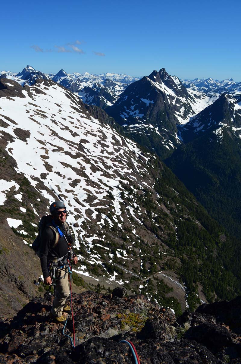
We were climbing closer and closer to the lefthand of the main buttresses, under the south summit. A few metres from the rock we stopped to look and chat and decided we could, should start up it. We could see a line of weakness and a definite angled traverse that looked like it would take us out to the left (south) of a horrendous, massif roof. I asked Hunter if he would get on the lead on it. He said 'yes' so up he went! Getting of the snow went smoothly, definitely a bonus of early summer conditions. I heard the scrabbling of mountain boots on the rock. Ummm looks a bit harder now he's actually on it!

The first pitch went up some amazingly clean and solid rock, 5.7 or so. Above I led an easy 4th class pitch up a shallow chimney/gully feature to a clump of cedars on a narrow ledge. Hunter joined me and headed out to the right end of our ledge and then up the edge of a gully. As I followed I found the climbing excellent. The rock was flawless, the moves fun and positive. The thrill of being on uncharted terrain, exhilarating!
We chatted about the east ridge and looked over at the upper difficulties and I recounted to Hunter my climb with my good friend Greg Shea on the wall next to us - Into the Sadistic… 20 years ago.
Another pitch of 5.7 brought us to the base of a steep wall and the dreaded lime green roof. A ledge covered in loose rock and a little heather ran off to the left of us and I scampered across it to the base of a beautiful looking corner. I say 'beautiful looking' but it also looked like it would lead us to steep terrain above. Hunter joined me and led off up a short chimney to the left. He shouted back some instructions about heading left at the top of the chimney and then disappeared round a prow and out of sight.

When my turn came to follow I scrambled up the chimney to a small chockstone. Small but still a couple of hundred pounds. I reached to retrieve a piece of protection and then gave in to the urge to test the chockstone. It quivered to the slightest touch! Spooked I stepped away from it and out on to the face to the left as Hunter had instructed. Up a few 5.6 moves and I saw the rope wrapping around the ridge in front of me. As I followed it along a narrow ledge Hunter suddenly came into view and along with him the awesome view and exposure of the whole upper Elk valley, Rambler PEak. Mt Colonel Foster.

Joining Hunter at the belay we were excited about our position perched out on the South Ridge. We figured we were now on the South Ridge route and started upward. The rock on the ridge crest was covered with that crunchy black lichen we all know and love. The rock generally was clean still, solid and the climbing fun. We followed a shallow gully/chimney swinging leads at 5.3 - 5.5. A traverse on some very precarious, loose blocks brought us around into a major gully and above that a ledge on the ridge crest with a huge boulder leaning against the upper summit block.
When Hunter joined me at the ledge we decided that we were definitely on the South Ridge route, the top was obviously right above us. Our duty in completing our new route was done and the setting sun was telling us it was time to get the heck off the mountain and back to camp.
We shopped around for a descent. My beta was hazy. The info I had said descend the route but rapping the south ridge the way we had just come looked terrible with little in the way of natural anchor options. So we settled on heading down the gully system we had just finished up. I headed down the first rap and found a set of horns that overlooked an adjacent gully. A full rope rappel free hanging brought us onto an open ledge system and then two more rappels down the gully brought us on to easier walking terrain. This all sounds short and sweet but fishing for anchors and dealing with a stuck rope ran the clock out pretty good and it was getting dark by the time we were on the easy ledges.
Luckily by then I had the ace of some beta from John Waters up my sleeve. John had told me about the traverse ledges so we worked them in the dark back toward the South col. All worked out fine and at midnight we pulled into our camp on the side of Mt Colwell.
Next day we roused slowly but still pretty early. We hiked up to the summit of Elkhorn South for a quick visit and then back down to the Elk River trail and the trailhead.
Our climb I guess could be called a direct start to the South Ridge. We called it the Catwalk, for the traverse ledge. We did 6 or 7 new pitches up to 5.8. The total to the south summit would be 13 pitches to 5.8.
Descent can be by rappel as we did, or: from the south summit traverse the summit pinnacles on the west side to the top of the west couloir at the summit boulder field and descend the west couloir to the west basin. A 3rd class gully leads down to the south west side of the mountain and the route back to the south col.
Comments
No comments posted yet.