
-
 28382 Hits
-
 84.82% Score
-
 19 Votes
|
|
Route |
|---|---|
|
|
43.89084°N / 103.48246°W |
|
|
Hiking |
|
|
Overview
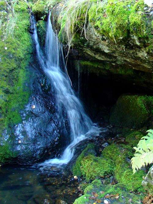
Small waterfall along Trail 14
The Horsethief Lake Trail (Black Hills Trail #14) is primarily in the Black Elk Wilderness. It is one of the most scenic trails in the wilderness, since it passes by numerous towering granite spires, small streams, and crosses two saddles with scenic views. The trail leads to the junction with the Grizzly Bear Trail, which is the closest a person can get to the center of the Black Elk Wilderness by trail. Horsethief Lake is located along Highway 244 about 1.5 miles northwest of Mount Rushmore and about 1 mile due west of Old Baldy Mountain.
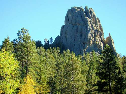
Granite Tower near the Horsethief Lake trailhead
Because of the towering granite spires in the area around Horsethief Lake and elsewhere in the Black Elk Wilderness, rock climbing is quite popular. The Wrinkled Rock Climbing Area and Old Baldy Mountain are not far away and are also popular destinations for area rock climbers. The rock climbing areas at The Needles/Cathedral Spires and Sunday Gulch are on the opposite side of the Black Elk Wilderness and can be reached by the trail network in the wilderness.
The elevation at the trailhead is around 5,000 feet and the highpoint of the trail is around 5,600 feet. Because of the elevation, the summer temperatures are a bit cooler than outlying areas of the Black Hills. Trees common in the wilderness include Ponderosa pine, spruce, birch, aspen and a few hardwoods. Pine Beetle damage has not spared the Black Elk Wilderness and the National Forest Service posts warnings of “snag” dangers, especially for windy days. Visitors to the wilderness will find abundant wildlife that includes mountain goats, deer, elk, bighorn sheep, mountain lions, coyotes, foxes, marmots, eagles and a large variety of other birds.
Getting There
The Horsethief Lake Trailhead is at the far end of Horsethief Lake from Highway 244, just 1l5 miles west of Mount Rushmore. Mount Rushmore is approximately 3 miles west of Keystone, South Dakota on Highway 244. There is camping, picnic areas, and toilets at Horsethief Lake.
Route Description
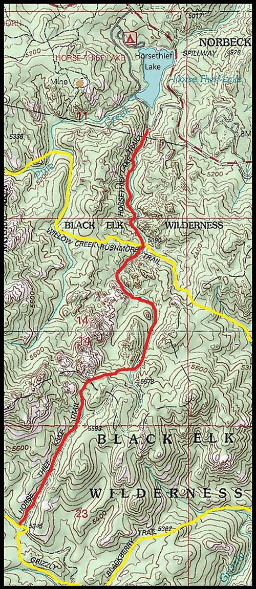
Horsethief Lake Trail Map
To get to the trailhead, either park at the lake and take the trail from the highway parking lot east around the lake to the trailhead, or you can drive to the trailhead parking area on the road just east of the lake.
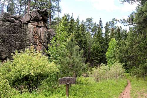
Center of the Black Elk Wilderness
Current trail information and regulations are posted at the trailhead sign. Hikers are required to register (free) at the trailhead for the Black Elk Wilderness. About a mile down the trail, the Centennial Trail (Black Hills Trail # 89) intersects with the Horsethief Lake Trail, expanding your options for additional hiking.
The Horsethief Lake Trail is 2.8 miles to the end, where you join the Grizzly Bear Creek Trail (Black Hills Trail #7). From there, you can go back, or go either direction on the Grizzly Bear trail. The trail west will take you to Black Elk Peak. If you plan to do a loop using some of the other trails in the wilderness, please be sure to get an up-to-date map. These are free at the Norbeck Visitors Center, Mount Rushmore, Sylvan Lake, or the visitor’s centers at Custer, Hill City, and Keystone.
The Horsethief Lake Trail and the Black Elk Wilderness lie in the Mount Rushmore USGS Quad. The National Forest Service has a good Black Elk Wilderness map available for free. The map can be downloaded from this link: Black Elk Wilderness Map
Essential Gear

Grizzly Bear Creek

View along Trail 14
The kind of gear you would want to take will vary greatly, depending on whether you are just doing an out-and-back, or are planning to spend some serious time camping or climbing in the Black Elk Wilderness.
The simple and short hikes will probably only require water, good footwear, sunscreen, insect repellent, sunglasses, your trail map, and maybe a hat. A camera is good for all the beautiful scenery you will see on this trail.
If you have any thoughts of going off-trail, be sure to include a compass and maybe GPS equipment. Hiking poles can be helpful. Some hikers feel better about carrying pepper spray for one of those rare encounters with a mountain lion. A small first-aid kit is a requirement of some hikers. If you are doing a long loop, extra socks and rain gear can prove helpful.
Red Tape

Black Hills Bighorn Sheep

Horsethief Lake Trailhead
Since the Horsethief Lake Trail is in the Black Elk Wilderness, everyone who hikes and climbs in the wilderness must fill out a free registration as they enter. The National Forest Service and allows camping anywhere within the wilderness, except within .25-mile of Black Elk Peak and Trail 9. Open fires are always prohibited.
For more information about the Black Elk Wilderness, check out his link:
USDA Black Elk Wilderness Information
When to Explore
The Black Elk Wilderness is open to the public all year, except during fire emergencies. Winter blizzards and summer hail and lightning will make visits risky, so for the latest weather forecast and conditions, please check out this link:
Mount Rushmore Area Weather Forecast and Conditions
Camping Options & Additional Information Links

Horsethief Lake

Horsethief Lake Trail Bridge
The National Forest Service manages the wilderness and can be reached by phone at (605) 673-9200. You can get more information online at: Black Hills National Forest Service
Horsethief Lake Campground
Horsethief Lake Campground on YouTube
Other Camping & Lodging Information
Black Hills Campgrounds
Mount Rushmore – Keystone Area Lodging Information