
-
 5191 Hits
-
 82.34% Score
-
 15 Votes
|
|
Route |
|---|---|
|
|
43.40980°N / 103.4686°W |
|
|
Hiking |
|
|
Spring, Summer, Fall |
|
|
Half a day |
|
|
Easy |
|
|
Overview
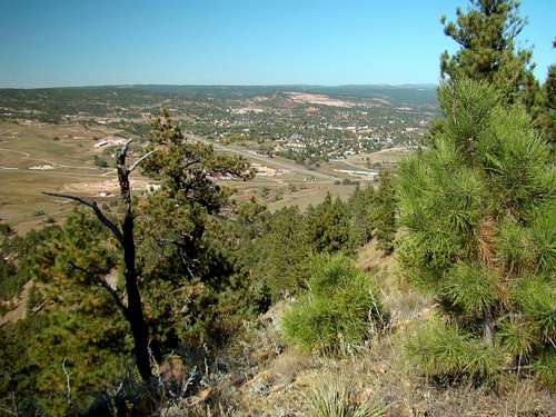
View from the ridge crest
There are very few hiking routes into the Seven Sisters Range in South Dakota’s Black Hills. The Seven Sisters North Route described here is not an official trail and lies in part on private land. For anyone who has desired a chance to explore summits in this range, the north route will give them access to the northern peaks on the higher western side of the Seven Sisters Range. In particular, this route provides access to Catholicon Mountain (4,120 feet) and two other peaks designated here as Boehnlein Ridge (4,190 feet) and Brady Peak (4,298 feet). None of these summit names appear on any maps. Catholicon has been the summit name locals have used for that mountain since the late 1800’s. The names appropriate to the other two summits are being used in conjunction with the named canyons that each one sits at the head of.
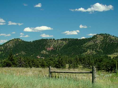
The saddle between Catholicon Mountain and Boehnlein Ridge
The potential exists to hike onward to the Seven Sisters Highpoint (4425) from Brady Peak. However, this becomes a very long route to reach the Seven Sisters HP (4425), given that it is on private land. If one is to obtain permission to summit that highpoint, it would be much shorter and simpler to just park at the Seven Sisters HP western base along East Cascade Mountain Road and hike up from there.
Concerning private property, it is important to know that the portion of this route that follows the old road is mostly on Allen Ranch land. In places, the road straddles Allen Ranch land and National Forest Service land. Boehnlein Ridge is also on forest service land, while Brady Peak is on private land that (as of the date this was written) had no posted restrictions for access. Much of the land immediately south of the forest service land is held by an out-of-state corporation that is largely inaccessible to the public. Catholicon Mountain land is held by several families and two corporations, none of which can usually be reached by phone. However, there are also no posted access restrictions to the summit of Catholicon Mountain. Most locals do not hike to the summit of Catholicon by this Seven Sisters North Route, but prefer to bushwhack directly from Hot Springs, which seems to be a long-standing local tradition.
Getting There

Route beginning

Loose gravel
The starting point for the Seven Sisters North Route begins at the Allen Ranch, about .5-mile southeast of Hot Springs, on the south side of Highway 385. It’s not always easy to drop in and find the person in charge there, so it is best to call ahead to obtain permission and arrange for a parking place. The phone number to call is (605) 890-0198. Ask for Mr. Allen. There is an old road that heads south from the dirt road circling through the Allen Ranch. It is just to the west of the Tee Pee area. That is where you will start your route.
Route Description
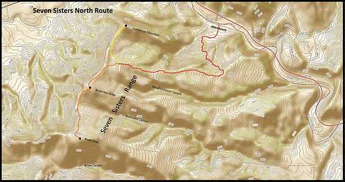 Seven Sisters Range North Route Map

Catholicon Mountain

Boehnlein Ridge
The beginning elevation at the Allen Ranch is about 3350 feet. The old road arcs from south to southwest across a small field. As you cross the field, the road fades out, so you will want to be sure to establish a line-of-sight to the old road that sharply ascends the ridge on the other side of the fence on the southern edge of the field. Pass through the gate and then you can begin your ascent up the old road to the top of the ridge. The old road winds around and gains around 350 feet in sometimes sharp ascent before you reach the broad and gently sloped ridge top. There has been quite a bit of erosion on this old road, causing it to be quite rough in places. Some places are hard to get sure footing on your return descent, due to loose gravel on steep surfaces. When you are past the steep ascent, you have come about .8-mile. If you have a compass, you will note that there is a change in general direction, heading now in a west-northwest direction. The road is quite faint in places. If for some reason you completely lose your track, please remember that you are on a ridge top following a route that stays on the ridge top. This route does not descend into the canyons on either side. That is probably just as well, since the canyon on the south side, Slaughterhouse Canyon, is over 500 feet deep in places, quite narrow and filled with trees and brush on the canyon floor. When you get to the top of the small hill on the saddle between Catholicon Mountain and Boehnlein Ridge, the road will finally disappear. At this point, you will have hiked about 1.8-miles total and with 750 feet of elevation gain. This is the junction point in the route. Here, you will have to choose whether to follow the Seven Sisters ridge crest .4-mile north to the Catholicon Mountain summit or .5-mile south to the Boehnlein Ridge summit. Brady Peak’ summit will be another .7-mile beyond Boehnlein Ridge.

Brady Peak
To go beyond the junction point to any of the three mentioned summits, will require dropping 120 feet and then gaining 132 to Catholicon Mountain; dropping about 60 feet and then gaining about 140 feet to Boehnlein Ridge; and finally dropping about 190 feet and then gaining close to 300 feet to Brady Peak. Should you decide to do all three peaks in one outing, you will have hiked at least 6.8 miles and ascended over 1,300 total feet.
Essential Gear

Upper Ridge View

Predator's Dinner
What you have in mind for your hike will determine what you should bring. A compass and GPS would be good, given the total lack of any trail markers or a well-defined trail. Mountain lions inhabit the area, so pepper spray is always a good precaution. For me, a camera is also essential. There is good cell phone reception on the ridge crest, so perhaps that would be an “essential” for some hikers. Footwear with a real grip is essential for going down the last steep stretch that is strewn with loose gravel. In fact, hiking poles might help there too.
Maps
The Seven Sisters North Route is located on the USGS Hot Springs Quad map. The best maps for the Seven Sisters Range include the Black Hills South by National Geographic and the official Black Hills National Forest map. Both can be purchased at most forest service offices, as well as locations at Custer State Park.
When to Hike
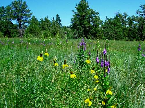
Wildflowers in the Seven Sisters Range
After obtaining permission from the Allen Ranch, be sure to check for local hunting season dates. Big game seasons, especially elk and deer can bring many hunters to the area. Wearing orange and making yourself visible is very important. You can learn more about South Dakota hunting seasons at this site:
South Dakota Hunting Seasons Information
Blizzards and deep snow, as well as summer hail and lightning are all deterrents to a good hike. Significant snow accumulation will totally obscure the trail. You can keep up to date on the area weather forecast and conditions by clicking here:
Seven Sisters & Hot Springs Area Forecast & Conditions
Forest Service Contact Information
Hot Springs District Forest Service Office
1801 highway 18
Hot Springs, SD 57747
(605) 745-4107