
-
 68512 Hits
-
 98.85% Score
-
 91 Votes
|
|
Area/Range |
|---|---|
|
|
46.35752°N / 14.53555°E |
|
|
Hiking, Mountaineering, Trad Climbing, Sport Climbing, Toprope, Bouldering, Ice Climbing, Aid Climbing, Mixed, Scrambling, Via Ferrata, Skiing |
|
|
Spring, Summer, Fall, Winter |
|
|
8392 ft / 2558 m |
|
|
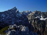
Overview
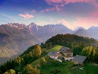 Hunkan - Alpine idyll
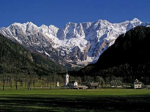 Jezersko resort with the northern faces of Kamnik/Steiner Alps
 haubi - From Velika planina (from the SE)
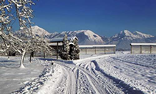 Kamnik Alps from Kranj (from the SW)
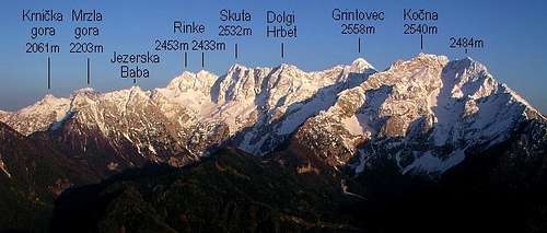 Kamnik/Steiner Alps from north-west
What's New On This Page?
> APR 29, 2022: Interactive map and pictures added.
> April 7th, 2013: SP V3 design updated.
Slovenian characters
When reading Slovenian words on maps or in books, you will find special characters for ch, sh, and zh (zh like in measure). They are written with c, s and z with a caron - a little v above them, like č, š and ž.
The name
The group I am describing here is named Kamniške and Savinjske Alpe (Kamnik is a town; kamen=stone, Savinja is a river). In German it is called Steiner Alpen (Stein=stone), which is a direct translation from Slovenian language. But I shall refer to the group shortly Kamnik Alps.
General characteristics
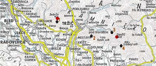
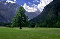
Kamnik Alps are the easternmost limestone group of the long chain of Southern Alps. Their area is 900 square kilometers. They look like Carnic Alps or Julian Alps - steep, rugged, with high and almost vertical north walls and with much less steep southern slopes. Although their altitude is not extremely high, Grintovec reaches 2558 m, their slopes are still considerably high. Kočna, for example, rises some 1800 m above Kokra valley and Grintovec rises 1900 m above Kamniška Bistrica valley. On the North Kamnik Alps are hard to distinguish from Karavanke range. You can see on the map below how the two groups are divided. To the South and to the West of the group Sava river plain lies, while towards the East higher mountains softly merge with forehills.
Summit Views and Other Vistas
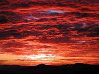 Bor - Krvavec sunset
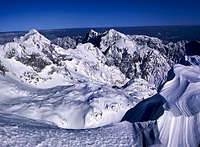 Grintavec view
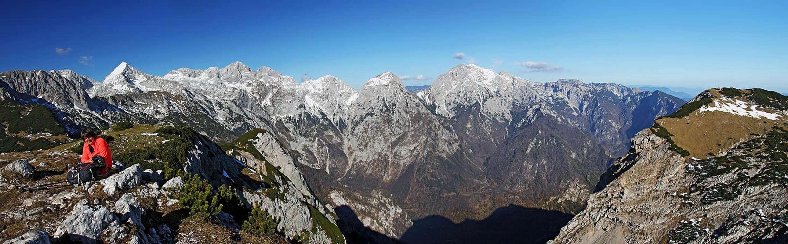
Rising on the edge of European Alps, Kamnik Alps are high enough to offer splendid vistas. The neighbouring higher groups are already a bit remote, so, standing in a nice day on top of Grintovec, you already see them on a horizon. Julian Alps, Hohe Tauern, Niedere Tauern, Dachstein - they are all quite remote, but clearly seen. From the West to the East the long range of Karavanke/Karawanken is passing Kamnik Alps on their North side. Karavanke are a bit lower, but still interesting to see.
Further to the North, beyond Drava/Drau river valley the rounded Gurktal Alps and Lavanttal Alps are clearly seen. Towards the South and the East you can freely see plains and hills of almost the entire Slovenia. While the Slovenian part of Dinaric Alps is well seen (Snežnik, for example), you must be very lucky to see also the Istrian hills and perhaps the mirror of Adriatic see as well. Kamnik Alps as a group itself can best be seen from the summits in Karavanke, above Jezersko - from Stegovnik, Virnikov Grintavec and Pristovski Storžič.
The other great point of view is the panoramic road below Olševa, also in Karavanke. From Gorenjska plane and from Ljubljana, the capital of Slovenia, Kamnik Alps form a characteristic scenery, which is on all tourist flyers of Slovenia. Also when arriving on Brnik airport, your plane will fly very close to the southern slopes of Kamnik Alps.
What To Do In Kamnik Alps?
- You'd try an ascent: Go on Jezersko (by car or by bus) and ascend Grintovec or Kočna and Grintovec in one day.
![Alpine Scenery Near Solcava]()
Alpine Scenery Near Solcava - You'd just drive around: Drive from Ljubljana over Jezersko to Austria, then over Pavličevo sedlo (saddle) and by the panoramic road below Olševa. Return through Savinja valley and Podvolovljek.
- You can do a hut-to-hut trip. There are many options, just to point on a nice example, here's the link to one quite commercial page of sabrinabrett.
Mountaineering Activities
You can enjoy all outdoor activities in Kamnik & Savinja Alps. In the group there are two quite popular ordinary ski resorts: Krvavec and Velika planina. The cable-car on Velika planina operates during the whole season, while on Krvavec, you can get in summer by car and in winter by cable-car. As for mountaineering, this is a great place for hiking, climbing (from short to long routes, all grades of difficulty), tour skiing, mountain biking, etc., to name just a few activities. If you plan just a short visit, here are a few highlights:
Hiking
- Do the central part of the group, for example from Grintovec to Ojstrica (2 days). Parts of this tour will be a medium hard ferratas.
- Do any of the high tours from Jezersko (medium hard ferratas: Kočna & Grintovec, Rinke or perhaps even Skuta).
- Ascend Ojstrica from Logarska dolina (medium hard ferrata).
- Go from Logarska dolina on Okrešelj and from there on any of the high summits above (ferratas). Also a round tour possible.
- Ascend Mrzla gora from Matkov kot in June (to see 'Škaf' - a big snow cone, holed in the middle by water).
Climbing
- Ojstrica N face
- Stajerska Rinka N face
- Dolgi Hrbet N face
The best areas for waterfall ice-climbing are:
- Jezersko (some 10 waterfalls),
- Kokra valley,
- Logarska dolina (almost 40 waterfalls),
- Matkov kot (quite remote).
Tour skiing
- From the summit of Grintovec (to Kamniška Bistrica or Kokra valley). Medium hard.
Mountain biking
- Veliki Zvoh from Cerklje
- Velika planina from Kamnik
Subgroups
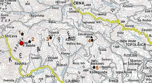
| View Kamnik Alps in a larger map |
One rarely speaks of Kamnik Alps subgroups, because the entire group is not big. Still I shall divide it into six subgroups. The central one holds almost all important peaks, while in the others there are just a few more important mountains. I shall name these groups: (1) Storžič group (lite blue), |
1. Storzic group
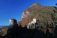 Grad Kamen
West of Kokra river Storžič dominates the surroundings. Its small group stretches to Tržič town, beyond which, further to the west there are some more forehills.
Important peaks:
- 2132 m Storžič:. A very dominant cone peak, rising 1500 m above the Gorenjska plane. Excellent panorama, many marked hiking routes, hard ski tour from the summit, some rock climbs in the North face.
- 1853 m Srednji vrh. Highest point of a plateau-like eastern part of Storžič group. A small mountain area, nice panorama, marked hikes.
- 1715 m Tolsti vrh. Nice panorama, hiking routes.
- 1634 m Dobrča. The summit just reaches out of woods to offer nice panorama.
Mountain huts:
- Koča na Dobrči, 1487 m, (04) 5971536, (031) 635396,
- Koča na Kriški gori, 1471 m, (041)784175 Ivan Likar, (050) 615623,
- Dom pod Storžičem, 1123 m, (04) 59 45 050, (040) 349 593,
- Dom na Kališču, 1540 m, (04) 2367850, (050) 614586.
 |
 |
 |
2. Krvavec group
|
Krvavec is not the highest summit of this group. But as it is so eye-catching from Kranj or Ljubljana, and so popular as a ski resort, let's name the group by it. The group rises to its highest point in Kalški greben, 2224 m, north of which Kokrsko sedlo, 1793 m, an important saddle, separates the group from the central part of Kamnik Alps. On the East, the slopes of this subgroup fall down to Kamniška Bistrica valley. On the southern end, there are wonderful, sunny terraces, with villages, cute churches and great views. There, on can do several short hikes as well. The very southern end of this subgroup is a hilly area called Tunjiško gričevje (Tunjice hills). Also a picturesque countryside, interesting for biking. Important peaks:
Mountain huts:
|
Two nice biking tours:
 |
 |
 |
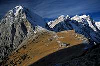
3. Central group of Kamnik Alps
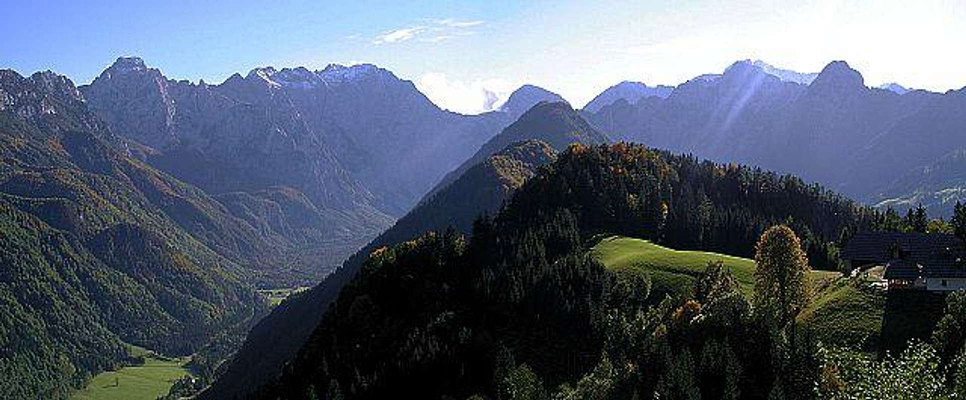
Kamnik/Steiner Alps from the North, across Logarska dolina (valley).
In this group all the highest summits are gathered. It is a wonderful mountain resort! High, almost vertical walls are falling towards the north, so Jezersko resort and Logarska dolina (valley) are first-class starting points for all sorts of hard climbs. Borders of the group are: on the West Kokra river and Jezersko valley, on the North Bela valley and Pavličevo sedlo (saddle), On the East Savinja valley and Robanov kot (valley) and on the South Kokrsko sedlo (saddle), Kamniška Bistrica valley and Korošica alpine meadow.
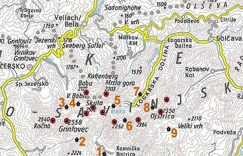
Important peaks:
- 2558 m Grintovec. Marked hikes, ferratas, first-class ski tour, hard climbs in the north wall, excellent panorama.
- 2540 m Kočna. Mighty rocky fortress with 3 peaks, marked ferratas, scrambles, extreme ski tours.
- 2532 m Skuta. Beautiful, sharp pyramid, ferratas, some climbs in the north wall.
- 2473 m Dolgi Hrbet. A ridge mountain which a medium hard, exposed ferrata crosses. N wall great for climbing.
- 2457 m Štruca. The summit a bit south of the main ridge. Funny, belly-shaped wall, hosting good climbs in a solid rock.
- 2453 m Rinka. Three summits, quite comfortably ascended from the south, from the north a medium hard ferrata.
- 2394 m Planjava. Broad, massive mountain, impressive north face. Marked hike, scrambles, many harder climbs.
- 2350 m Ojstrica. Sharp cone peak, marked hike, hard ski tour, nice north wall with hard climbs.
- 2253 m Brana. Nicely shaped mountain on the main ridge. Marked path and several scrambles and easy climbing ascents.
- 2251 m Turska gora. A ridge mountain wich a secures path crosses. Some harder ascents in the N wall, also an attractive couloir from the N side.
- 2203 m Mrzla gora. A remote, wild mountain indented towards the N. Ferratas and secured paths reach the top.
- 2127 m Zeleniške špice. A wild side ridge, falling down to Kamniška Bistrica valley. Nice ridge climb.
- 2127 m Velika Baba. Attractice summit in the N side chain. A marked, exposed path crosses it.
- 2110 m Vellacher Turm / Storžek. A cone peak at the end of Vellacher Kotschna / Belska Kočna. Short ferrata on top.
- 2100 m Kogel. A secondary summit above Kamniška Bistrica valley. Nice S wall with many hard climbing routes.
- 2083 m Krofička. Nice, stand-alone mountain Between Logarska dolina and Robanov Kot. A secured path reaches its top.
- 2064 m Krnička gora. A hardly reachable mountain N of Mrzla gora. No path reaches its top.
- 1957 m Matkova kopa. A rugged, hardly reachable summit in the N ridge of Mrzla gora.
- 1761 m Jerebičje/Grintoutz. The northernmost, unimportant summit above Pavličevo sedlo. Nice view.
 The summits from Grintovec to Ojstrica from the south, from Vrh Korena
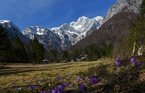
Trailheads & Mountain huts:
- Jezersko
- Kamniška Bistrica. Dom v Kamniški Bistrici, 600 m.
- Logarska dolina (2) Dom v Logarski dolini, 837 m.
- Cojzova koča na Kokrskem sedlu, 1793 m.
- Češka koča na Spodnjlh Ravneh, 1543 m.
- Kranjska koča na Ledinah, 1700 m.
- Frischaufov dom na Okrešlju, 1396 m.
- Kamniška koča na Kamniškem sedlu, 1864 m.
- Koča na Klemenči jami pod Ojstrico, 1208 m.
- Kocbekov dom na Korošici, 1808 m.
Bivouacs: Bivouac Pavel Kemperl on Veliki Podi, Bivouac Pod Skuto on Mali Podi, Bivouac in Kocna.
 |
 |
 |
 |
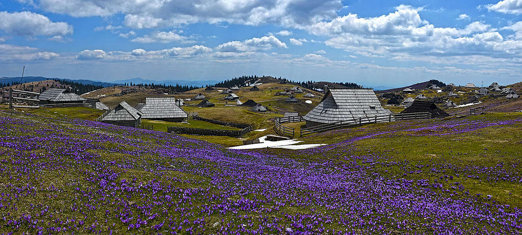
4. Velika Planina - Dleskovska planota - Rogatec group
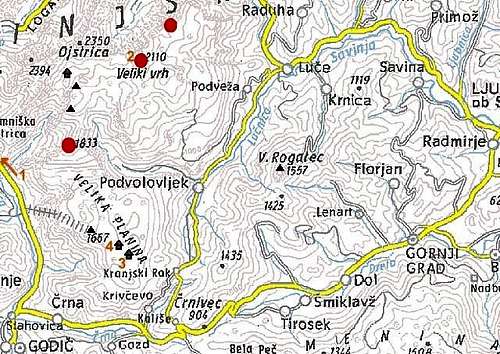
In this group I am gathering two high plateaus and summits above them and a lower mountain ridge on the other side of Podvolovljek valley. Dleskovška planota (also called Veža) is a high carst plateau, with peaks above it that hardly exceed the 2000 meters altitude. Velika planina is different. Also a high plateau, hosting many opened, grassy alpine meadows. Both plateaus are connected by a sharp ridge with an impressive NW face. The Rogatec ridge is mostly covered with woods, only the two highest peaks are grassy and rocky. The whole area has the following frontiers: Robanov kot (valley) on the North, Savinja valley on the East, Dreta valley and Črna valley on the South and Kamniška Bistrica valley, Kamniška Bela valley and Korošica alpine meadow on the West and North-West.
Important peaks:
- 2110 m Veliki vrh. A lonesome rocky cone above the plateau. Easy scramble, also a ski tour.
- 2023 m Lučki Dedec. A rocky summit above the Korošica alpine meadow. Unmarked path, some hard climbs in the west face.
- 1980 m Vežica. Unimportant summit south of Dedec, but with some fine rock climbs in the west face.
- 1909 m Križevnik. The edge of the north drop of Veža plateau. Unmarked path, some hard climbs in the north face.
- 1833 m Rzenik. From south a grassy summit north of Velika planina, marked path, easy ski tour. North-west face with very hard climbs.
- 1666 m Gradišče. A grassy hill, the highest point of Velika planina. Ski lifts, nice panorama.
- 1557 m Veliki Rogatec. A sharp, rocky mountain, the highest in its own ridge. Ferrata, steep, marked hike. The nearby Lepenatka is also a nice, panoramic summit, appropriate for tour skiing.
Mountain huts:
- Dom v Kamniški Bistrici, 600 m, (01) 8325544,
- Kocbekov dom na Korošici, 1808 m, (03) 4924850, (050)615625 and (031)749811, Milan Kozelj,
- Domžalski dom na Mali planini, 1534 m, (01) 832 57 16, (050) 647523,
- Črnuški dom na Veliki planini, 1526 m, (040) 502 896 Janez Kutnar, 031) 519 753.
 |
5. Menina planina
 Vivodnik south view
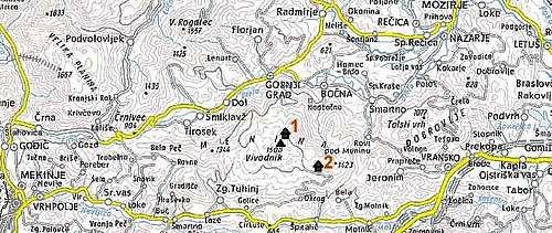
A broad area of hills, covered with woods, south of Dreta valley. Nice for hiking and mountain biking. The plateau can be accessed from both sides - south and north. From the south you start in Tuhinj. In the beginning the road has a sign that it is prohibited for drive, but the plate below says you can proceed on your own responsibility. Above, the first big meadow is Biba planina, higher on, there's Menina planina. Close to the hut on menina planina (15 minutes away) rises the highest point.
Highest peak:
- 1508 m Vivodnik.
Mountain huts:
- Dom na Menini planini, 1453 m, (03) 5843249, (041) 783 668,
- Planinsko zavetišče na Bibi, 1309 m,
 Biba pl. Biba pl. |
 Menina pl. Menina pl. |
 Biba pl. Biba pl. |
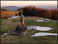
6. Raduha - Smrekovec group
The easternmost part of Kamnik Alps. Raduha is a broad, rocky ridge mountain, while Smrekovec is a long grassy ridge, the only ex volcano in Slovenia. On south-east there is a hilly Golte plateau, hosting a ski resort. Below Raduha summit (10 minutes from the road) there's a nice Snezna jama (Snow Cave), arranged for tourist visits.
Important peaks:
- 2062 m Raduha. Easy marked path, also a ski tour. Nice ice cave. Some rock climbs in the north face. Nice panorama.
- 1684 m Komen The westernmost summit of Smrekovec ridge. Easy marked path.
- 1577 m Smrekovec The easternmost summit of the ridge, the only extinct volcano in Slovenia. Easy marked path.
Mountain huts:
- Koča na Grohatu, 1460 m, (03) 8384220, Moličnik Franc, (050) 629150 and (041) 968022,
- Koča na Loki, 1534 m, (050) 612678, (041) 690011,
- Antejevo zavetisce, 1520m,
- Koča na Smrekovcu, 1375m, (02)8238084, (050) 632459,
- Mozirska koča na Golteh, 1360m, (03) 5831121.
 |
 |
 |
 |
 |
Maps
|
You can use my online maps, available by the links on the left. Four maps referring to Kamnik & Savinja Alps are available:
If you get the map which is in Slovenian language, switch to the English map by clicking the INFO and then choosing the English flag. |
One Tiny Glacier
Below Skuta, oriented a bit towards the NE, a small glacier persists, the only one in Kamnik/Steiner Alps and, together with the disappearing Triglav glacier the most south-eastern one in Alps. Its altitude is from 2020 m to 2120 m, inclination some 30–35 degrees, and area only some 0,7 hectars. From almost hundred years ago (1913) a picture of Josip Kunaver still shows big crevasses, today the average thickness of ice is only 7 meters.
Caves
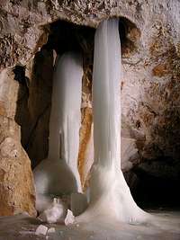 Snežna jama
As a predominantly limestone formation, Kamnik Alps are a nice example of a high, mountain karst. Erosion effects can be seen everywhere, some most typical examples are on Dleskovska planota (plateau). On higher regions all water soon disappears underground. The deepest cave, discovered so far, is the Molička peč system, 1130 m of depth. Two entrances of this system are 200 m apart on the altitude of 1900 m, East of Veliki vrh and Velika zelenica and South of Poljske device ridge. This is nowadays the fourth deepest cave in Slovenia, the deepest one outside Kanin mountain group. On Dleskovska planota and elsewhere there are some more objects, none of them appropriate for a tourist visit. On Raduha, however, there is Snežna jama (Snow cave). It was discovered only in early 1970-ies, when snow on the entry melted enough. Today it is arranged for tourist visit and the 2-hours visit can be really recommended. At the begining there are nice ice waterfalls, while deeper the cave is nicely decorated (even if it is situated rather high on the mountain). In forehills, near Šempeter, there's also a nice cave, called Pekel (Hell), also arranged for tourist visite. Bit it's already very low, not in high mountains. There are some more interesting objects, like for example Medvedja jama (Bear Cave) above Kamniška Bistrica valley. There, bones of hundreds of cave bears were found. It can be an interesting hike, although the place is not so easy to find.
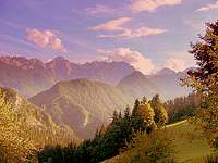
Valleys, Rivers and Waterfalls
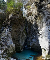
 toc - Logarska dolina
 Matkov škaf (Matk's Tub)
 Matkov škaf (Matk's Tub)
In the vicinity of Jezersko resort, many sources join and flow down towards Gorenjska plane as Kokra river. While offering some nice scenes, Kokra is touristically not very important. But Jezersko itself is a very nice place. A small plane, formed by glaciers, was once a natural lake (today, you can only see a small artificial lake) and is on one side surrounded by a high wall of Kamnik Alps and on the other side by a few lower peaks of Karavanke. Some of the sources on Jezersko have mineral water. In the walls of Kočna one of the sources immediately falls down in waterfall. This is Čedca, the highest waterfall in Slovenia (but poor with water). It is best to visit it early in spring. In Reka valley, the right tributary creek of Kokra tufa was mined. You can still see big blocks close to the mountain road.
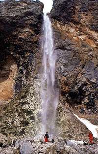 Rinka waterfall
Kamniška Bistrica has its source (a small lake) in the valley with the same name. This glacial valley is deeply cut in the heart of Kamnik Alps group. The altitude difference between the river source and Grintovec is more than 1900 meters. The canyon towards Kamnik town is nice to see (in spring, for example), along a big part of it a nice marked path goes. The most beautiful part of it are the two Predoselj gorges. The side tributary creeks of Kamniška bistrica also hide a few nice places. One such place is a small waterfall and some ponds in Repov kot, the other one is Orglice waterfall on Bela creek.
Savinja is also a nice river in the eastern part of the group. Our kids were doing it by tyre tubes, otherwise there are some rafting and kayaking possibilities. The most beautiful waterfall in Kamnik Alps is Rinka, close to Savinja source. A fine stream of water is falling over an interestingly red rock. Further down, the canyon of Savinja is most beautiful on the place, where the river cuts its way between the main part of Kamnik Alps group and Raduha, rising East of the river. Driving through, you can for example stop by Igla (The Needle) and do some sightseeing).
On the upper part of Savinja river basin there are three famous mountain valleys: Robanov kot, Logarska dolina and Matkov kot. Above all of them high walls of surrounding mountains are rising, the first two are flat in the lower part, with nice meadows, while Matkov kot is covered with woods. At the end of Matkov kot, already quite above the valley, each year the so called Matkov škaf (Matk's Tub) is formed. Big amounts of snow are falling over the walls, but in spring, water carves a broad hole, from the top to the bottom of the snowdrift. In old guidebooks it is said that the phaenomenon can have a diameter from 20 m - 30 m on top and can be 40 m deep! When I visited it in 2008, it was half of that size, but still very impressive.
Getting There
 haubi - A winter impression
AIR. The nearest airport is close to Ljubljana, the capital of Slovenia. The next closest airport is in Klagenfurt, Austria.
RAIL. Timetable for Slovenia Austrian train schedules
ROAD. The roads leading to the trailheads may be seen by clicking the coordinates in the primary info, and then using the map version.
By car. See the map. You can reach Tržič and the Lom valley (behind Storžič). To Jezersko resort and up by a few forrest roads. To Kamnik and in Kamniška Bistrica valley. Further up by a few forrest roads. To Kamnik and Črnivec pass (902 m), further north to Volovljek pass (1029 m) and down in Podvolovljek. From Volovljek pass up by forrest roads to Mala planina. From Podvolovljek up by forrest roads to Dleskovška planota (plateau). From Savinjska dolina (valley) deep into valleys of central part: Robanov kot, Logarska dolina, Matkov kot. By a forrest road to Koča na Grohatu. From Austria into Bela (Vellach) valley. Further over Pavličevo sedlo (pass, 1339 m) to Savinjska dolina (valley). By forrest roads to Smrekovec hut and Golte. By forrest roads on Menina planina. Etc.
By bus. The main trailheads may be attained by bus. Bus info: enter Jezersko, Kamniška Bistrica, Logarska dolina, Lom or Tržič in the destination field. Here is info for the Vellach trailhead (Austria).
MAPS. Kamniške in Savinjske Alpe. Planinska zveza Slovenije, 1:50000. Grintovci. Planinska zveza Slovenije, 1:25000. These two maps give a general idea of hut access for the central group.
Red Tape
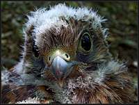 Falco tinnunculus
 Falco tinnunculus
In the whole area there are no major limitations. Currently some areas are protected as natural reserves, but that has no impact on mountaineering and visiting those areas. On December 19th, 2005 an agreement was signed that almost the whole central area of the group will become a regional parc. The formal establishing of the parc is foreseen in 2007. Natura 2000 For the road into the Logarska dolina (valley) you must pay toll.
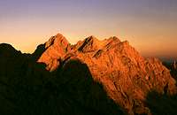
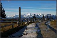
When To Climb
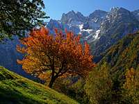 Autumn above Belska Kočna
 haubi - Late autumn
In summer best months are from start of July till end of October. For tour skiing the best months are from February till May. First snow usually falls in November, in certain areas skiing is possible till start of May. Best areas for tour skiing: Parts of Storžič group, the whole Krvavec group, Grintovec, area around Rinke, Ledine area, Okrešelj area, Dleskovška planota, Velika and Mala planina. Best areas for climbing: Walls above Jezersko, walls above Logarska dolina, walls above Robanov kot, many shorter climbs in areas above Savinjska dolina, sunny walls above Kamniška bistrica (valley) and a shadow wall of Rzenik.
Camping
 haubi - Kamnisko sedlo with its hut
In valleys there are many tourist resorts. Huts are mentioned above. In the massif itself there are no camping places. Some mountain farms are also licensed to accept tourists. That's certainly one option to recommend. People who spent vacation on Roban's farm, for example, can not praise enough the quality of their service - zither concerts in the evening included. Camping around the range: Ljubljana Kamnik, Luce, Tržič, Voelkermarkt
 |
 |
 |
Mountain Conditions
For weather see here.
A More Distant History of This Page
| - January 31st, 2011: Links updates, pictures attached/detached, Menina planina shortly described. - Jun 29th, 2009: Links updates, pictures attached/detached. - Jan 12th, 2007: The 'One Tiny Glacier' chapter added. - Dec 11th, 2006: A major renewal of the page. Links to Križevnik page added. - Added links to new SummitPost Pages: Dobrča, Mrzla gora, Veliki vrh. - Info about establishing a regional parc posted. - Nov 5th, 2005 - Added links to the new SummitPost Page: Krofička. - Jun 24th, 2005 - Added links to the new SummitPost Page: Rzenik and Konj. - May 12th, 2005 - Added links to new SummitPost Pages: Planjava, Brana. - Apr 25th, 2005 - Added links to new SummitPost Pages: Vrh Korena, Veliki Zvoh and Krvavec. |
- Mar 13th, 2005 - Inserted an overview picture from north. - Mar 13th, 2005 - Added links to the new SP Page: Košutna. A detailed map of Krvavec group added. - Mar 9th, 2005 - Added links to the new SummitPost Page: Kompotela. - Feb 16th, 2005 - Added links to the new SummitPost Page: Velika Raduha. - Jan 16th, 2005 - Added links to the new SummitPost Page: Velika Baba. - Dec 13th, 2004 - Added links to the new Rinke SummitPost Page. - Sep 17th, 2004 - Added links to the new Skuta SummitPost Page. - Sep 3rd, 2004 - Added links to the new Kalski greben SummitPost Page. - Jul 5th, 2004 - Added links to Ojstrica SummitPost Page. |