
|
|
Mountain/Rock |
|---|---|
|
|
43.41380°N / 110.36074°W |
|
|
Teton |
|
|
Scrambling |
|
|
Spring, Summer, Fall |
|
|
11657 ft / 3553 m |
|
|
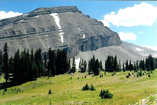
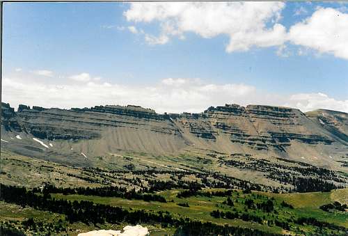
Black Peak is the second highest mountain in the Gros Ventre Range; it may also be one of it's most isolated peaks. Other than the fact that the mountain has a definite darker look to it (see primary image), I can find no other reason for the name. One wishes a less prosaic name could have been found, but I guess we are stuck with it. Standing in the center of the range, the views from the summit and on the way up are very nice. The panoply of peaks surrounding the upper Gros Ventre River basin along with the Six Lakes area are especially good. If a person approaches the peak from the Swift Creek trail head or by way of Crystal/Jagg Trails to Six Lakes, the climb can even be done in a long day. Overall a worthy, though little known mountain in a less traveled range. Give it a try!
![Black Peak]()
Black Peak
![Black Peak]()
Black Peak region aerial view
Swift Creek Trail Head (Elevation - 6,780'+)
The shortest, most direct way to the mountain is from the Swift Creek trail head. To get there from Jackson, Wyoming drive south on U.S. Highway 189/191 thirteen miles to Hoback Junction. From here travel generally east a little over twelve miles up the Hoback Canyon to the Granite Creek road(FSR-30500). It's nearly nine miles up the Granite Creek road to the Swift Creek trail head on the right (FSR-30520), or 34 miles from Jackson. There is a bridge across Granite Creek at the correct turn; also at this spot you may notice the trail head for the eastern terminus of the Highline Trail(FST-019). Granite Falls is only one mile further up the road and well worth a look.
![Swift Creek Trailhead]()
Swift Creek Trail head
TRAIL HEAD AREA MAP ( from Granite Falls 7.5 minute quad)
![Black Peak]()
From summit of Black Peak looking southwest. Macleod Peak on the left skyline; Antionette Peak on the right.
Crystal Creek Trail Head (Elevation - 7,220'+)
The second access point would be the Crystal Creek trail head. To get here travel north from Jackson,Wyoming on U.S. Highway 191 seven miles to the Gros Ventre Junction. At the junction turn right and go six miles to the hamlet of Kelly, Wyoming. About one mile north of Kelly turn right on the Gros Ventre Road (FSR-30400). The road is paved until it nears the east end of Slide Lake at which point it turns into a well-graded gravel road. From here it is another 5 miles to Crystal Creek campground. Just a mile further on the road past the campground, after crossing the bridge over Crystal Creek, you'll see the turn off for Red Rock Ranch to the right. At the gate to the ranch a small, bad road leads left two miles around the ranch to the Crystal Creek trail head, for a total of 26 miles from Jackson.
![Black Peak]()
Crystal Creek Trail head Map
![Black Peak]()
Along the Jagg Creek Trail
Kinky Creek Trail Head (Elevation - 8,800')
The third and longest approach drive is that leading to Kinky Creek trail head on the far eastern end of the Gros Ventre range. To get here, travel as in the Swift Creek approach, except go all the way up the Hoback Canyon, over the Hoback Rim and on towards Pinedale, Wyoming. About 3 miles past the Warren Bridge over the Green River look for the 40-Rod Road heading to the left off the highway, about 61 miles from Jackson, Wyoming. Drive this road five miles over to the Green River Lakes road (State Road 352). From Pinedale , Wyoming drive 6 miles west on U.S. 189 to State Road 352 and travel north. Turn left on this Green River road and travel north to about two miles past the end of pavement; just past Whiskey Grove Campground, to the start of the Union Pass road on the left (FSR-600). On up this gradually worsening road travel six miles past Tosi Creek bridge to the Kinky Divide road(FSR-620)heading to the left. The trail head is another six miles and just above the gate to Darwin Ranch(private). Altogether about 105 miles to Kinky Creek trail head from Jackson.
![Gros Ventre River Trail]()
Gros Ventre River below Upper Falls
![Black Peak]()
Kinky Creek Trail head map
![Black Peak]()
Black Peak sub summit from upper Gros Ventre River trail
ROUTE ONE-SOUTHWEST RIDGE
From the Swift Creek trail head it is a steadily uphill about five miles up to the Antionette Peak/Corner Peak saddle at 10,400'. Then another mile traverse east on an unofficial trail not on the map brings one to the junction with the Crystal Creek/Gros Ventre trail(FST-021). A short walk generally north from this Crystal Creek/ Gros Ventre River divide(locally known as the "the top") brings you to a pretty little lake at 10,480+. This is a great place to camp. From the lake, head north between the two pinnacles ahead which I like to call "the twins" for their similarity. At the top of this chute turn right or east and climb over the east "Twin". By the way, the left, or west "twin", is practically a peak in it's own right and easy to climb. You are now on the southwest ridge of Black Peak; it is an easy, straight forward climb over Point 11,160'+ up this ridge to Black Peak summit.
Mileage from Swift Creek Trail Head ---@7.5 miles one-way
Total Elevation Gain -------------@ 5,220' +
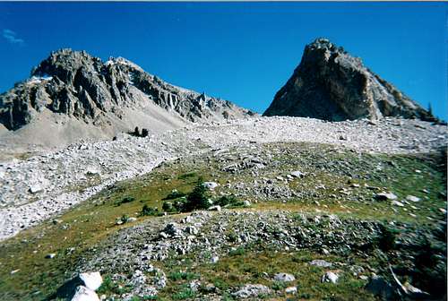
![Black Peak]()
Black Peak from Corner Peak's lower slopes
![Gros Ventre River-Crystal Creek divide in June]()
The clouds on the right give new meaning to the word brooding!
![Black Peak]()
Black Peak Southwest Ridge begins here
While up there why not scramble over to Black Peak's eastern sub summit, a class 3 jaunt. Going all the way up Crystal Creek Trail or approaching from Kinky Creek trail head and the Gros Ventre River Trail will bring you to this same little lake at 10,480+ as in the Swift Creek entrance. Both ways are very beautiful backpacks if time permits. I recommend making this climb a backpacking trip because even the long day hikes hinted at in the overview will be brutal affairs on account of the distances and large elevation gains.
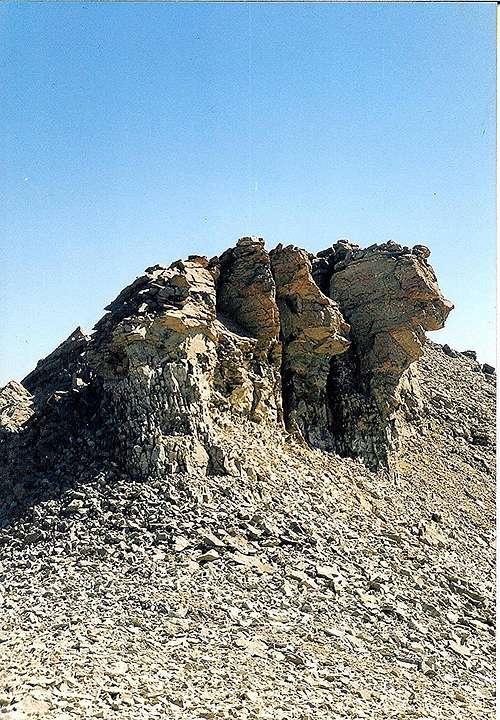
![Black Peak, Southwest Ridge]()
Interesting rock formation showing crumbly nature of this ridge
![ROUTE UP BLACK PEAK FROM SIX LAKES]()
ROUTE UP BLACK PEAK FROM SIX LAKES
ROUTE TWO-NORTH SLOPES
From the Crystal Creek trail head travel three miles more or less to the Jagg Creek trail(FST-084). I should state here that if a person doesn't want to cross Crystal Creek twice in the first mile, dangerous in early season, there is an option. At the trail head there is a little trail heading up the hill starting behind the signboard to the left. This takes one up and over the cliffs ahead and keeps your feet dry. I have read some horror stories fearful of this little route; trust me it's not that bad! This trail is not for horses. At any rate travel around three miles, then turn left uphill on the Jagg Creek trail and follow it about three miles steadily uphill to a large meadow with a hunting camp below Crystal Peak at 8700'. It's another two miles south and uphill on this trail to the Six Lakes cutoff trail heading right or west. Now you are entering one of the truly special areas in the Northern Rocky Mountains, so please tread lightly!
![Six Lakes]()
Heading into the magical Six Lakes area
Mileage from Crystal Creek Trail Head (via Six Lakes )----@9.5 miles one-way
Total Elevation Gain --------------- 5,100' +
Mileage from Crystal Creek Trail Head(up Crystal Creek ) --@12.5 mi.one-way
Total Elevation Gain---------------- 4,640' +
Mileage from Kinky Creek Trail Head----@16.0 miles one-way
Total Elevation Gain----------------- 3700' +
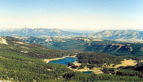
![SIX LAKES AREA FROM BLACK PEAK]()
SIX LAKES AREA FROM BLACK PEAK
Red Tape
This is fully protected Wilderness, and should be treated as such. Try to tread very lightly in the extra special areas such as around the Six Lakes; in the area around Lake 10,480'+, and in the upper regions of Swift Creek, Crystal Creek and the Gros Ventre River drainage. On hikes in late season wear orange clothing as this is hunting season. Please bring a stove for any cooking which must be done. Having a fire at or near timberline leaves scars on the land which take a long time to heal. Use existing fire rings if a fire must be made.
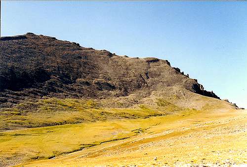
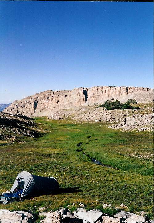
![Black Peak]()
High camp on Black Peak's north side
![Eastern Gros Ventre Range]()
Looking up the Gros Ventre River
drainage from Bacon Ridge
The best times to climb this mountain, as in most mountains in the Yellowstone area, is from about mid-June in a dryer year to about the end of September. Dealing with a little snow can probably extend the window a couple of weeks on either end.
![Gros Ventre River]()
Unusual Ouzel Falls in full July flow
![Pinnacles above the Six Lakes]()
Pinnacles above the Six Lakes
![Black Peak]()
Six Lakes basin from high up on Black Peak
Excellent dispersed camping available on all the approaches to this peak. Especially choice ones exist at Lake 10,480+ at base of southwest ridge of Black Peak. The Six Lakes region as a whole offers beautiful, private camp sites. The upper Gros Ventre drainage and The Meadows on Crystal Creek are also nice areas to camp.
![Black Peak high camp]()
Black Peak high camp
Outfitters guiding in the Gros Ventre Wilderness:
1) Black Diamond http://blackdiamondoutfitting.com/
Pinedale, Wyoming
1-866-470-1516
2) Darwin Ranch http://darwinranch.com/
P. O. Box 2407
Cody, Wyoming 82414
1-307-733-5588
3) Goosewing Ranch www.goosewingranch.com
P. O. Box 4084
Jackson, Wyoming 83001
1-888-733-5251
![Gros Ventre Range]()
Horse packing in the wilderness
WWW.CLIMBER.ORG (STATE MOUNTAIN LISTS) (Lots of interesting stats and facts here about all things mountainous)
USEFUL MAPS:
USGS Jackson 30 minute (100,000 scale) approach
Pinedale 30 minute (100,000 scale) approach
Grizzly Lake 7.5 minute Crystal Creek+6 Lakes Routes
Crystal Peak 7.5 minute All Routes
Ouzel Falls 7.5 minute Kinky Creek Route
Granite Falls 7.5 minute Swift Creek Route
Darwin Peak 7.5 minute All Routes (Black Peak Summit)
http://www.weather.gov - Local Weather conditions(closest town is Bondurant, Wyoming)
![Gros Ventre Range]()
Antionette Peak, Point 11,204' and Black Peak from the east

Black Peak
Getting There
There are basically three different trail heads one can use to access Black Peak; each of these access points have their own charms.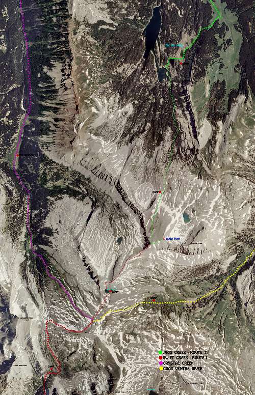
Black Peak region aerial view
Swift Creek Trail Head (Elevation - 6,780'+)
The shortest, most direct way to the mountain is from the Swift Creek trail head. To get there from Jackson, Wyoming drive south on U.S. Highway 189/191 thirteen miles to Hoback Junction. From here travel generally east a little over twelve miles up the Hoback Canyon to the Granite Creek road(FSR-30500). It's nearly nine miles up the Granite Creek road to the Swift Creek trail head on the right (FSR-30520), or 34 miles from Jackson. There is a bridge across Granite Creek at the correct turn; also at this spot you may notice the trail head for the eastern terminus of the Highline Trail(FST-019). Granite Falls is only one mile further up the road and well worth a look.

Swift Creek Trail head

From summit of Black Peak looking southwest. Macleod Peak on the left skyline; Antionette Peak on the right.
Crystal Creek Trail Head (Elevation - 7,220'+)
The second access point would be the Crystal Creek trail head. To get here travel north from Jackson,Wyoming on U.S. Highway 191 seven miles to the Gros Ventre Junction. At the junction turn right and go six miles to the hamlet of Kelly, Wyoming. About one mile north of Kelly turn right on the Gros Ventre Road (FSR-30400). The road is paved until it nears the east end of Slide Lake at which point it turns into a well-graded gravel road. From here it is another 5 miles to Crystal Creek campground. Just a mile further on the road past the campground, after crossing the bridge over Crystal Creek, you'll see the turn off for Red Rock Ranch to the right. At the gate to the ranch a small, bad road leads left two miles around the ranch to the Crystal Creek trail head, for a total of 26 miles from Jackson.
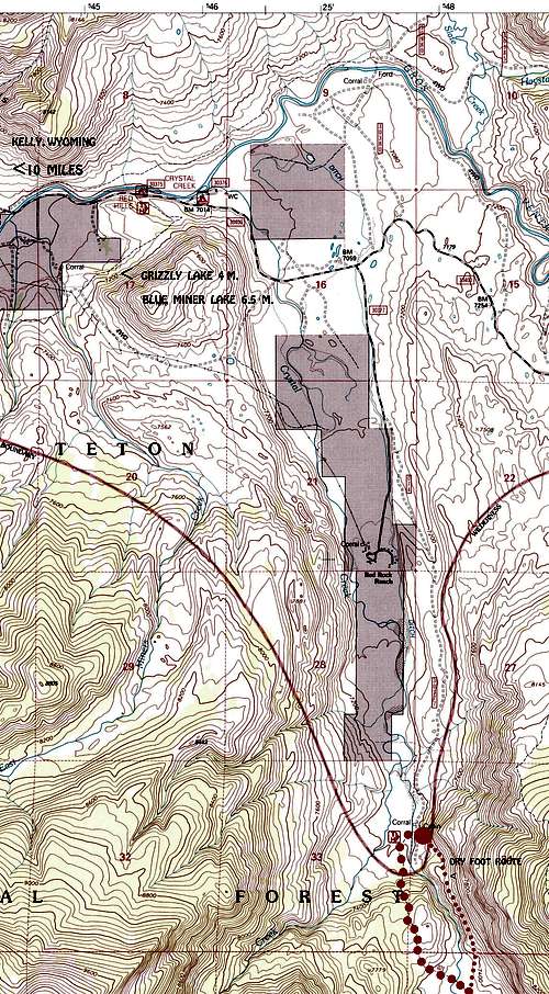
Crystal Creek Trail head Map

Along the Jagg Creek Trail
Kinky Creek Trail Head (Elevation - 8,800')
The third and longest approach drive is that leading to Kinky Creek trail head on the far eastern end of the Gros Ventre range. To get here, travel as in the Swift Creek approach, except go all the way up the Hoback Canyon, over the Hoback Rim and on towards Pinedale, Wyoming. About 3 miles past the Warren Bridge over the Green River look for the 40-Rod Road heading to the left off the highway, about 61 miles from Jackson, Wyoming. Drive this road five miles over to the Green River Lakes road (State Road 352). From Pinedale , Wyoming drive 6 miles west on U.S. 189 to State Road 352 and travel north. Turn left on this Green River road and travel north to about two miles past the end of pavement; just past Whiskey Grove Campground, to the start of the Union Pass road on the left (FSR-600). On up this gradually worsening road travel six miles past Tosi Creek bridge to the Kinky Divide road(FSR-620)heading to the left. The trail head is another six miles and just above the gate to Darwin Ranch(private). Altogether about 105 miles to Kinky Creek trail head from Jackson.

Gros Ventre River below Upper Falls
Kinky Creek Trail head map

Black Peak sub summit from upper Gros Ventre River trail
ROUTE ONE-SOUTHWEST RIDGE
From the Swift Creek trail head it is a steadily uphill about five miles up to the Antionette Peak/Corner Peak saddle at 10,400'. Then another mile traverse east on an unofficial trail not on the map brings one to the junction with the Crystal Creek/Gros Ventre trail(FST-021). A short walk generally north from this Crystal Creek/ Gros Ventre River divide(locally known as the "the top") brings you to a pretty little lake at 10,480+. This is a great place to camp. From the lake, head north between the two pinnacles ahead which I like to call "the twins" for their similarity. At the top of this chute turn right or east and climb over the east "Twin". By the way, the left, or west "twin", is practically a peak in it's own right and easy to climb. You are now on the southwest ridge of Black Peak; it is an easy, straight forward climb over Point 11,160'+ up this ridge to Black Peak summit.
Mileage from Swift Creek Trail Head ---@7.5 miles one-way
Total Elevation Gain -------------@ 5,220' +

Black Peak from Corner Peak's lower slopes

The clouds on the right give new meaning to the word brooding!
Black Peak
While up there why not scramble over to Black Peak's eastern sub summit, a class 3 jaunt. Going all the way up Crystal Creek Trail or approaching from Kinky Creek trail head and the Gros Ventre River Trail will bring you to this same little lake at 10,480+ as in the Swift Creek entrance. Both ways are very beautiful backpacks if time permits. I recommend making this climb a backpacking trip because even the long day hikes hinted at in the overview will be brutal affairs on account of the distances and large elevation gains.
Interesting rock formation showing crumbly nature of this ridge
ROUTE UP BLACK PEAK FROM SIX LAKES
ROUTE TWO-NORTH SLOPES
From the Crystal Creek trail head travel three miles more or less to the Jagg Creek trail(FST-084). I should state here that if a person doesn't want to cross Crystal Creek twice in the first mile, dangerous in early season, there is an option. At the trail head there is a little trail heading up the hill starting behind the signboard to the left. This takes one up and over the cliffs ahead and keeps your feet dry. I have read some horror stories fearful of this little route; trust me it's not that bad! This trail is not for horses. At any rate travel around three miles, then turn left uphill on the Jagg Creek trail and follow it about three miles steadily uphill to a large meadow with a hunting camp below Crystal Peak at 8700'. It's another two miles south and uphill on this trail to the Six Lakes cutoff trail heading right or west. Now you are entering one of the truly special areas in the Northern Rocky Mountains, so please tread lightly!

Heading into the magical Six Lakes area
Mileage from Crystal Creek Trail Head (via Six Lakes )----@9.5 miles one-way
Total Elevation Gain --------------- 5,100' +
Mileage from Crystal Creek Trail Head(up Crystal Creek ) --@12.5 mi.one-way
Total Elevation Gain---------------- 4,640' +
Mileage from Kinky Creek Trail Head----@16.0 miles one-way
Total Elevation Gain----------------- 3700' +
SIX LAKES AREA FROM BLACK PEAK
Red Tape
This is fully protected Wilderness, and should be treated as such. Try to tread very lightly in the extra special areas such as around the Six Lakes; in the area around Lake 10,480'+, and in the upper regions of Swift Creek, Crystal Creek and the Gros Ventre River drainage. On hikes in late season wear orange clothing as this is hunting season. Please bring a stove for any cooking which must be done. Having a fire at or near timberline leaves scars on the land which take a long time to heal. Use existing fire rings if a fire must be made.
High camp on Black Peak's north side
When to Climb

Looking up the Gros Ventre River
drainage from Bacon Ridge
The best times to climb this mountain, as in most mountains in the Yellowstone area, is from about mid-June in a dryer year to about the end of September. Dealing with a little snow can probably extend the window a couple of weeks on either end.

Unusual Ouzel Falls in full July flow
Camping

Pinnacles above the Six Lakes
Six Lakes basin from high up on Black Peak
Excellent dispersed camping available on all the approaches to this peak. Especially choice ones exist at Lake 10,480+ at base of southwest ridge of Black Peak. The Six Lakes region as a whole offers beautiful, private camp sites. The upper Gros Ventre drainage and The Meadows on Crystal Creek are also nice areas to camp.
Black Peak high camp
Outfitters guiding in the Gros Ventre Wilderness:
1) Black Diamond http://blackdiamondoutfitting.com/
Pinedale, Wyoming
1-866-470-1516
2) Darwin Ranch http://darwinranch.com/
P. O. Box 2407
Cody, Wyoming 82414
1-307-733-5588
3) Goosewing Ranch www.goosewingranch.com
P. O. Box 4084
Jackson, Wyoming 83001
1-888-733-5251

Horse packing in the wilderness
WWW.CLIMBER.ORG (STATE MOUNTAIN LISTS) (Lots of interesting stats and facts here about all things mountainous)
USEFUL MAPS:
USGS Jackson 30 minute (100,000 scale) approach
Pinedale 30 minute (100,000 scale) approach
Grizzly Lake 7.5 minute Crystal Creek+6 Lakes Routes
Crystal Peak 7.5 minute All Routes
Ouzel Falls 7.5 minute Kinky Creek Route
Granite Falls 7.5 minute Swift Creek Route
Darwin Peak 7.5 minute All Routes (Black Peak Summit)
http://www.weather.gov - Local Weather conditions(closest town is Bondurant, Wyoming)

Antionette Peak, Point 11,204' and Black Peak from the east