
|
|
Mountain/Rock |
|---|---|
|
|
46.17681°N / 10.94817°E |
|
|
Trentino Alto-Adige |
|
|
Hiking, Scrambling |
|
|
Summer |
|
|
8068 ft / 2459 m |
|
|
Overview
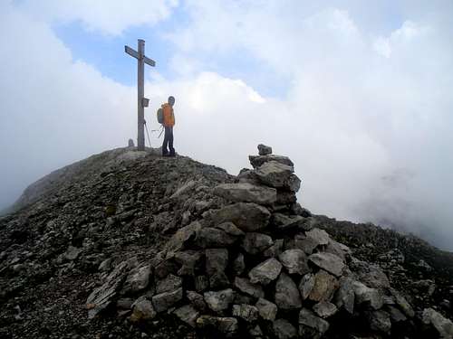
Cima dei Lasteri 2459 m
Cima dei Lasteri 2459 m is a summit belonging to the Brenta Dolomites, subgroup Massiccio dell'Altissimo, located in the Eastern sector of the Group; the mountain is connected by two long ridges to the best known Croz dell'Altissimo, located to the South-West, and Piz Gallino, located to the East and it rises like a high pyramid over Passo del Clamer, dominating both and Conca di Malga Spora and Vallazza. On the other hand - when seen from the South - Cima dei Lasteri has the appearance of a steep but easy summit, overlooking the tableland of Lasteri and the basin of Mandrini. The ascent to Cima dei Lasteri from the southern side is therefore a climb without particular difficulties, a classic climb known in reason of the beauty of the landscapes and the great views over the surrounding Brenta Group and the most distant peaks of the Dolomites and the Eastern Trentino.
Cima dei Lasteri m 2459 è una cima appartenente alle Dolomiti di Brenta, sottogruppo del Massiccio dell'Altissimo, situata nel settore orientale del Gruppo; la montagna è collegata da due lunghe creste al più noto Croz dell'Altissimo, situato a sud-ovest, e al Piz Gallino, situato ad est e si erge come un'alta piramide sul Passo del Clamer, che domina entrambi e Conca di Malga Spora e Vallazza. Dall'altra parte - vista da sud - Cima dei Lasteri ha l'aspetto di una montagna ripida ma facile che domina l'altipiano di Lasteri e il bacino dei Mandrini. La salita alla Cima dei Lasteri dal versante sud è quindi una salita senza particolari difficoltà, una salita classica conosciuta soprattutto per la bellezza dei paesaggi e degli splendidi panorami sul circostante Gruppo del Brenta e sulle vette più lontane delle Dolomiti e del Trentino Orientale.
Getting There
The usual starting point to climb Cima dei Lasteri is Molveno m. 890, a nice village in the southern end of Brenta Group.
Main road access to Molveno
- Coming from A22 Brennero Motorway (South direction) exit Trento Centro, then follow the SS 45 towards Riva del Garda, getting to the village Le Sarche. From here take the SS 237 and after 11 km. turn to right towards Molveno and San Lorenzo in Banale (8 km. from the last junction).
- Coming from A22 Brennero Motorway (North direction) exit Rovereto Sud, then get to Arco. From here follow Valle del Sarca - route SS45 bis to Le Sarche. From here take the SS 237 and after 11 km. turn to right towards Molveno and San Lorenzo in Banale (8 km. from the last junction).


From Molveno m 890 we take the cable car up to Pradel, where a second chairlift brings us to the Refuge La Montanara m 1530.
Route
Cima dei Lasteri Normal route
Summit quote: 2459 m
Difficulty: EE
Difference in level: 930 m
Exposition: S and W
Starting point: Rifugio La Montanara
An excellent panoramic route to get the summit of Cima dei Lasteri. The route doesn't involve any kind of climbing, reaching the summit along the W slopes of the mountain.


From Refuge La Montanara 1525 m. take the path heading to the North-East following the signposts to Croz dell'Altissimo. The trail enters the forest, rising steeply along the cool and shady fir-wood with numerous bends and reaching a crossroads. Here ignore the path on the right in the direction of the saddle of Piz Gallino and continue following the main signposts to Croz dell'Altissimo. The trail leaves the firs-forest and follows a rocky ridge covered by mountain pines with a magnificent view above the central sector of the Brenta Group, bypassing to the right (East) the Palòn di Tovre.


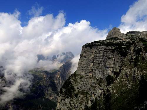
Later the itinerary reaches the saddle of Passo dei Camosci m. 1953, from where it follows a succession of large boulders with some ups and downs, crossing a beautiful rock crevasse and climbing a brief rock slope to reach and enter the vast basin named Conca dei Mandrini, at the foot of the southern side of Cima dei Lasteri. To the left it appears the summit cross of Croz dell'Altissimo, whose ascent can easily be combined with the Lasteri one. The trail crosses the wide Conca dei Mandrini, getting to a junction with signposts.

Take the right direction to follow a path between grass and rocky slabs with several white-red marks on wooden poles in the direction of Passo dei Lasteri and Passo del Clàmer. The trail reachs a scree-slope and a second junction; here you must leave the main itinerary to Passo del Clàmer and begin to climb the scree-slopes on the right following tracks and cairns and getting along a steep path the sharp and panoramic summit of Cima dei Lasteri.
,...")

Descent: reversing the same route. During the descent, once getting the junction between Lasteri and Cross dell'Altissimo, it's possible to climb in about 15 minutes also the summit of Croz dell'Altissimo, following the left path (see above the photo of the junction).
Italian version
Un ottimo percorso panoramico per raggiungere la vetta della Cima dei Lasteri. Il percorso non prevede alcun tipo di arrampicata, raggiungendo la vetta lungo il pendio Ovest della montagna. Dal Rifugio La Montanara 1525 m. imboccare il sentiero in direzione nord-est seguendo le indicazioni per il Croz dell'Altissimo. Il sentiero entra nella foresta, salendo ripidamente lungo la fresca e ombreggiata foresta di abeti con numerosi tornanti e raggiungendo un incrocio. Lasciato a destra il sentiero in direzione della sella del Piz Gallino si prosegue seguendo le indicazioni principali per il Croz dell'Altissimo. Il sentiero esce dalla foresta di abeti e segue un crinale roccioso coperto da pini mughi con magnifica vista sul settore centrale del Gruppo di Brenta, scavalcando a destra (est) il Palòn di Tovre. Successivamente l'itinerario raggiunge la sella del Passo dei Camosci m. 1953, da dove segue un susseguirsi di grandi massi con alcuni saliscendi, attraversando un bellissimo crepaccio di roccia e salendo un breve pendio roccioso per raggiungere ed entrare nella vasta Conca dei Mandrini, ai piedi del versante sud della Cima dei Lasteri. A sinistra appare la croce di vetta del Croz dell'Altissimo, la cui salita può essere facilmente abbinata a quella dei Lasteri. Il sentiero attraversa l'ampia Conca dei Mandrini, giungendo ad un incrocio con indicazioni. Prendere la direzione verso destra e seguire un sentiero tra erba e lastre rocciose con diversi segni bianco-rossi su pali di legno in direzione del Passo dei Lasteri e del Passo del Clàmer. Il sentiero raggiunge una ghiaione e un secondo bivio, dove si deve lasciare l'itinerario principale per il Passo del Clàmer e iniziare a salire i ghiaioni sulla destra seguendo tracce e ometti. Percorrendo questo ripido sentiero si raggiunge la panoramica vetta di Cima dei Lasteri.
Discesa: lungo lo stesso itinerario. Durante la discesa, una volta raggiunto il bivio tra Lasteri e Croce dell'Altissimo, è possibile salire in circa 15 minuti anche la cima del Croz dell'Altissimo, seguendo il sentiero a sinistra.
Essential gear
Normal high mountain gear: hiking boots, backpack, sunglasses, gloves, cap, supplies, spare clothing.
Red Tape
No fees, no permits required.
Hiking and scrambling grades of difficulty
T - Turistico (Tourist): Itineraries on wide, clear and well worn paths, sometimes on mule tracks or gravel roads. The routes are never exposed, don't give any orientation problems and don't exceed 2500 meters of altitude. Suitable also for children.
E - Escursionisti (Hikers): Itineraries on marked trails, even narrow and with possible steep and impervious sections. They are never exposed and don't give any orientation problems. They can tread different kinds of ground, such as forests, gravel, meadows, pastures, easy rocks, etc.). They form the majority of the trails that wind up in the mountains and require a certain habit to walk; you need equipment suitable for the altitude and resistant footwear with soles suitable for rough terrain.
EE - Escursionisti Esperti (Experienced Hikers): Itineraries for hikers with experience and good knowledge of the mountain. Some of these paths may have exposed sections, however brief, which require firm foot and no dizziness. They require the ability to adapt to particular terrain, such as steep grassy slopes or stretches of rocks with difficulties that can reach the 1st degree of the UIAA scale. They can also reach high altitudes (3000 m or more). Sometimes they may include unmarked sections, requiring a good sense of orientation. Snow slopes are possible, however which can be overcome without specific mountaineering gear (rope, harness, crampons, ice-axe).
EEA - Escursionisti Esperti con Attrezzatura (Experienced Hikers with equipment - The same as EE, in addition these routes require the use of via ferrata equipment (lanyards, harness, carabiners, heat sink, helmet). This kind of itineraries range from the trails with short easy and not much exposed sections, previously equipped with fixed ropes and iron pegs, to the true and more difficult Via Ferratas climbing on rocky walls or on aerial ridges and ledges, previously equipped with long stretches of iron ropes, iron steps, ladders without which proceeding would constitute a real climbing. It is necessary to know how to use the technical equipment and have a certain habit of exposure and mountaineering terrains.
When to Climb
Mountaineering: from May to October Ski-mountaineering: from February to the end of March
Huts and other kind of accomodation

Molveno offers different kinds of accomodation.
Bibliography
"Dolomiti di Brenta" - Gino Buscaini - Guide dei Monti d'Italia CAI-TCI