
|
|
Mountain/Rock |
|---|---|
|
|
46.09208°N / 11.08553°E |
|
|
Trentino |
|
|
Hiking |
|
|
Spring, Summer, Fall, Winter |
|
|
2648 ft / 807 m |
|
|
Overview
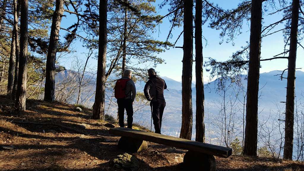
Sorasàss-Soprasasso 807 m
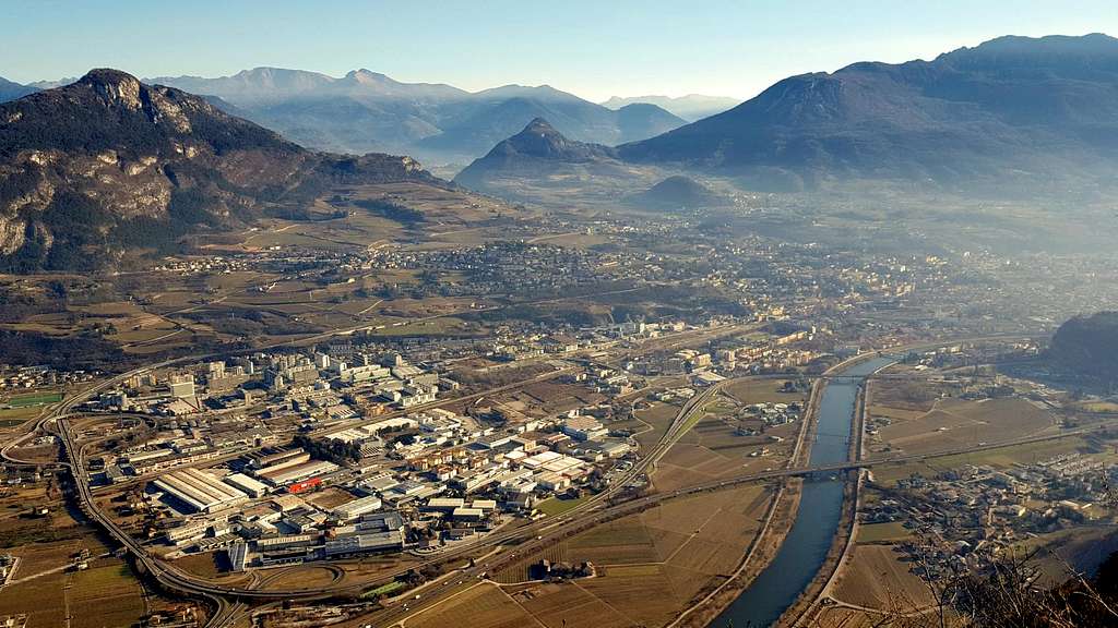
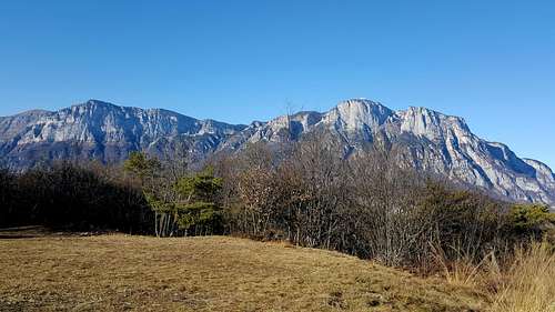
The Soprasasso 807 m - Sorasàss in the local dialect - is a minor summit that is geographically part of the Paganella Group, located above the village of Cadine, opposite the majestic walls of the same Paganella. On the opposite side the mountain overlooks the Adige Valley and the town of Trento with a formidable 700 meters drop wall. It's a mountain neither flashy nor imposing, but full of history and suitable for a short and quick half a day round trip, the "Tour of Sorasàss", an interesting itinerary with low gradient entirely practicable even by MTB. In the years before the WWI or "Great War", when the county of Trentino was a province of the Austro-Hungarian Empire on the border with the Kingdom of Italy, the Austrians built a majestic system of observation points, trenches and fortifications, fearing an invasion by the Italians.
Even in the mountains just surrounding Trento, like the Sorasàss, many military structures were built to defend the city, as happened along the whole front line running along the current "Sentiero della Pace". The Sorasàss was heavily fortified and the military works were continued until the early 1915, just before Italy entered the war, aiming at the "Fortress of Trento" defensive rampart that stretched across the ridge opposite the city. Numerous caves were built, dormitories and warehouses as well as observatories with stations for cannons and machine guns. Many of these fortifications are nowaday still visible.

|

|
")
|
Getting There
The nearest village is Cadine 492 m, 5 kilometers from Trento. The village is located at the beginning of the Valle dei Laghi, along the road 45 leading from Trento to Lago di Garda.
- Coming from the A22 - Exit Trento and take the road towards the "Bus de Vela", direction Valle dei Laghi. Once out of the long tunnel of the Bus de Vela, turn to right and at the next roundabout turn to right again. After passing a couple of bends, you reach Cadine. Here, at the traffic lights, you turn to right again and follow the signposts to the sports area, then continuing straight for a dead end road that leads at the parking lot "Fer de Caval", where it's located a picnic area. Park your car here.
Route: Sorasàss trekking circuit
Sorasàss round walk
Difficulty: T (Easy Walk)
Difference in level: 300 m from Fer de Caval (507 m)
A pleasant walk, with an exceptional panorama over the Adige Valley and the city of Trento, and the chance to visit some WWI old military installations. The route is a ring about 7 km long, without difficulty and generally gentle-angled.
Starting from "Fer de Caval" 507 m the round trail obviously can be followed in both directions. The itinerary below described is in a clockwise direction. Following the dirt road rising gently to the North until you reach first the remains of an old "Calcara", an oven in shape of a truncated cone, and then the "Poza de la Casara" 710 m, a large clearing.
 on the summit of Sorasà ss")
|

|
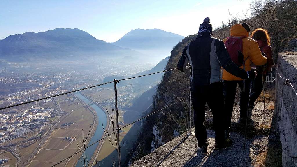
The trail continues to the hamlet "La Polsa of Fausto" ("Fausto rest") another large clearing with a beautiful view over Paganella and Canfedin. Now the trail leads on the panoramic ridge of the Sorasass, facing East, getting the altitude 807 m, the maximum altitude provided by this path. Successively the trail will be mainly on level or downhill. Continue along the dirt road coming in a few minutes to "Pontesel", a veritable eagle's nest overlooking the Adige Valley. The Pontesel is one of the "highlights" of this trail, the place probably more rich in "remains" of the Great War. There are circular platforms in concrete that served as according to anti-aircraft artillery pieces, numerous artifacts, caves and a fantastic observatory, accessible on a brief but very exposed trail, equipped with lanyard and protected in the part falling down for about 700 meters toward the Val d'Adige. Continue the path passing the <b>"Baita Laura" and several "Stoi", caves into the rock used as shelters for the garrison and stores for food and ammunition. In this stretch of the path we constantly follow the old military trail with frequent view down to the city of Trento. Then the military road begins to descend, a detour to the right leads us to visit the "fuciliera austriaca", fully restored in 2006, another "highlights" of this trail. Here we can put our signature on the summit-book.

|

|
After this brief deviation the trail returns to the dirt road and continues downhill getting the "Poza dei Pini", a large clearing where there is a junction with the trail SAT n. 627 coming from Vela, a suburb of Trento. We turn to right and continue westward always following the forest road of Val Granda along the West slopes of Sorasàss. The trail meets different signposted sites as "Quatro Strade" ("Four Roads") and two junctions signposted "Vintitré pini", (meaning Twenty-three pine trees), where it's possible another detour . This area was so-named because of the deforestation carried out during the build of the fortifications, to allow a better visibility over the surrounding area. It is said that only 23 pine trees were left to protect some positions for artillery. After the juncions the itinerary gets a beautiful meadow basin called "Busa degli Acazi" and then the "Fer de Caval".
Red Tape
No fees and no permits required
Hiking and scrambling grades of difficulty
T - Turistico (Tourist): Itineraries on wide, clear and well worn paths, sometimes on mule tracks or gravel roads. The routes are never exposed, don't give any orientation problems and don't exceed 2500 meters of altitude. Suitable also for children.
E - Escursionisti (Hikers): Itineraries on marked trails, even narrow and with possible steep and impervious sections. They are never exposed and don't give any orientation problems. They can tread different kinds of ground, such as forests, gravel, meadows, pastures, easy rocks, etc.). They form the majority of the trails that wind up in the mountains and require a certain habit to walk; you need equipment suitable for the altitude and resistant footwear with soles suitable for rough terrain.
EE - Escursionisti Esperti (Experienced Hikers): Itineraries for hikers with experience and good knowledge of the mountain. Some of these paths may have exposed sections, however brief, which require firm foot and no dizziness. They require the ability to adapt to particular terrain, such as steep grassy slopes or stretches of rocks with difficulties that can reach the 1st degree of the UIAA scale. They can also reach high altitudes (3000 m or more). Sometimes they may include unmarked sections, requiring a good sense of orientation. Snow slopes are possible, however which can be overcome without specific mountaineering gear (rope, harness, crampons, ice-axe).
EEA - Escursionisti Esperti con Attrezzatura (Experienced Hikers with equipment - The same as EE, in addition these routes require the use of via ferrata equipment (lanyards, harness, carabiners, heat sink, helmet). This kind of itineraries range from the trails with short easy and not much exposed sections, previously equipped with fixed ropes and iron pegs, to the true and more difficult Via Ferratas climbing on rocky walls or on aerial ridges and ledges, previously equipped with long stretches of iron ropes, iron steps, ladders without which proceeding would constitute a real climbing. It is necessary to know how to use the technical equipment and have a certain habit of exposure and mountaineering terrains.
Nature
Cadine is located within the "Tre Cime del Monte Bondone" newly established as a nature reserve. This trekking circuit is also interesting in reason of its flora (oak trees, white and black beech, manna ash, Scots pine) and fauna (deer and raptors including goshawk, sparrow-hawk, brown kite, honey buzzard).
When to Climb
All year round
Accomodation
Valle dei Laghi and the close Valle del Sarca offers different kinds of accomodation.
Bibliography
Map: Kompass 75 Trento-Levico-Lavarone 1:50000