|
|
Mountain/Rock |
|---|---|
|
|
38.65530°N / 106.283°W |
|
|
13872 ft / 4228 m |
|
|
Overview

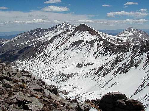
Formally known as "North Carbonate Peak," Cronin Peak was renamed in 2005 by the USGS in honor of Mary Cronin. She became the first woman to summit the 53-list of Colorados Fourteener's and the first woman to reach the summit of Lone Eagle Peak and El Diente (San Juan Mountains). The current altitude of Cronin Peak is 13,872 and is adjusted for the new LIDAR measurements.
It is Colorado's 75th highest peak and lies on the top-100 highest list of peaks/mountains. Cronin Peak lies southwest of Mt. Antero and more or less, sandwiched in between a small group of other equally high 13ers in the Central Sawatch. It is rather isolated from the others by Baldwin Gulch & Deer Canyon. But it's very doable to combine it with the other peaks. It occupies the Saint Elmo Quadrangle and is located in Chaffee County. It carries 1,057' of prominance and is very dog friendly.
Cronin Peak is accessible by way of its ESE ridge if you have a vehicle capable of making it up FR278 which, is the road up Mt. Antero. That tedious road is best tackled with a shorter-bed, higher clearance 4WD vehicle. You can park around 12,700 feet to begin the hike. From this junction, many other peaks are possible in the area. Once on the saddle/ridge, it is also possible to start south at Carbonate Mountain and work your way north to the summit of Cronin. The difficulty is all class-2 at most and the day will net you around 3-5 easy peaks, weather dependent of course.
There are no big or major mines located near Cronin. Although, there are smaller, lower-output prospects and diggings sprinkled throughout both valleys.
Cronin is a good winter peak offering eastern ski descents and a moderate north ridge snow climb. The lower valley gets VERY cold in winter. Dress appropriately!
Getting There
From Buena Vista, drive 11 miles south on highway 285 to the small town of Nathrop (more of a bedroom community than anything else). Drive over Chalk Creek and turn right onto Chalk Creek Drive/Cty. Road #162. Follow this west for 13.2 miles to Alpine Lake passing by the Mt. Princeton Hot Springs.
At Alpine Lake, look to the left (south) for Baldwin Gulch Jeep Road. It is signed. Some maps also have this marked as county road #277. Keep in mind, THIS IS A ROUGH ROAD. Unless you know how to drive off-road, think twice about taking a stock vehicle all the way up. Modified vehicles will have no problem. It seems every year, Baldwin Gulch Road gets a little more challenging due to all the spin-outs. There aren't too many places to turn around. So drive up early to avoid oncoming vehicles. It's a popular summer destination for Jeeps/trucks and OHV's.
Follow Baldwin Gulch Road for 2.8 miles. There is good parking at the confluence of West Baldwin Creek and East Baldwin Creek. The altitude here is about 10,880' and just past Baldwin Creek. The normal, North Ridge Route of Cronin Peak is accessed from here. Good water access.
Baldwin Gulch Road is NOT maintained in winter.
Red Tape
As stated, French Mountain lies in the Pike/San Isabel National Forest. Forest regulations are considerably more relaxed than wilderness. But in general, here are a few guidelines and rules for visits to national forests:

- Maximum stay of 14 days
- Follow current campfire restrictions
- No fireworks
- FIrearms (certain restrictions apply).
- Pets must be on a leash in developed areas
- Of course, leave no trace and pack out all trash.
Camping

Buena Vista is the closest, largest town in the Arkansas River Valley. Fortunately, it is also fairly close to Baldwin Gulch/Alpine Lake area. Camping is easy to find in the vicinity. Check out the following suggestions of where to lay your head at night. Basically everything is measured from Buena Vista. Grab your supplies in BV. There is nothing in Nathrop save for a post office.
Chalk Creek Campground: Creekside tent campsites and RV sites near the creek give Chalk Creek Campground and RV Park a tranquil and serene feel. Don’t be fooled, however–this park is close enough to all of the sites that Buena Vista and Nathrop offer while offering a peaceful getaway. There are restrooms, laundry and access to Chalk Creek for fishing. There is a playground for the kiddies (and adults) and horseshoe pits. It's roughly 1 mile from Nathrop and 8.5 miles from Buena Vista.
Cascade Campground: A perfect place to settle if you’re looking to explore Cascade Falls, Cascade Campground offers a total of 21 campsites for you to pitch your tent or pull your RV into. Enjoy fishing above the falls or the hike the variety of trails available in the area. There are 21 tent pad sites along with vault toilets, drinking water, fire pits and picnic tables. From Buena Vista, drive west on Main Street until you reach Co Rd 321/Rodeo Rd. Turn left and follow the road for about 8 miles. Turn right onto Co Rd 162 and continue for 5 miles, then Cascade Campground will be on your left. You can make advanced reservations at the Recreation.gov website.
Mt. Princeton Campground: Mt. Princeton Campground is a great place to lay your head for the night–it’s located near the trailhead for those who want to try their luck with mountain climbing, as well as close to Chalk Lake for fishing and boating. There are 19 primitive sites for tents with vault toilets, picnic tables, fire pits and tent pads. From Buena Vista, head west on Main Street, then turn onto Rodeo Rd/Co Rd 321. Continue for 8 miles, then turn right onto Co Rd 162. Follow this road for almost 4 miles, then Mt. Princeton Campground will be on your right. Make reservations here.
Mountain Conditions / When to Climb
Cronin Peak is an alpine environment. So expect wild temperature swings, possible snow in any month, lightning, AMS, intense UV etc. could happen at any moment. Dress and plan accordingly. This is an easy mountain to hike in summer. But course, emergencies can happen. Expect an easy day but plan for contingencies. Cronin Peak does make for a great BC ski trip. Be avalanche aware.
Of course, being prepared when venturing into the backcountry will make for a safer and overall, more enjoyable trip for everyone. Many wilderness education courses and organizations preach the ten essentials. Consider the following selections when packing:
- Matches/lighter
- Knife
- Food & Water
- FIrst Aid Kit
- Emergency Shelter (poncho, ground cloth etc.)
- Sunglasses/Sunscreen
- Map & Compass
- Flashlight/torch + batteries
- Signling device(s)
Depending on what I'm doing, how far & how long I plan on being out and route choice, I will usually bring some combination of the aforementioned. It's always best to have contingencies already planned for. There's been a lot of SAR rescues in the Colorado backcountry as of late. I'm sure some of those instances could be categorized from poor route-finding and lack of experience, but other rescues could have been prevented by proper planning.
Mary Cronin

From the wonderful website, Wander Women Project.
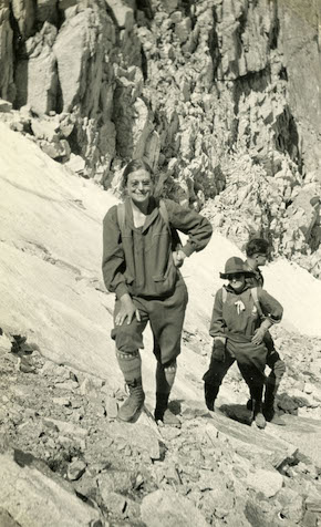
Cronin was born in Denver, Colorado, to a working-class family. After graduating high school at 16, she began to work as an accounting clerk at Western Union, a job she held until her retirement. At the age of 27, she was bored and seeking new experiences, so on April 24, 1921, she joined a hiking trip of the Colorado Mountain Club to Beaver Brook Trail. Afterward, she became a regular guest of the CMC and soon became a member. Only four months after her first hike, she climbed her first Fourteener – Longs Peak at 14,259 feet. It was led by Agnes Vaille, an experienced climber and one of the early members of the CMC. From this day on, the two paired up to accomplish the mission of becoming members of the 14,000-Footers Club – an exclusive list of people who climbed all of Colorado’s fourteeners. In the following years, the two climbers traveled throughout the state, summiting one peak after another, and by the age of 31, Cronin had reached the summits of more than 23 fourteeners. She became the forth person to summit all Colorado's Fourteeners.
On January 12, 1925, Agnes Vaille climbed the east face of Longs Peak and froze to death during a surprise snowstorm. Cronin’s response to her friend’s tragic death was to dedicate her life to accomplish Vaille’s dream to become the first woman to climb all of Colorado fourteeners. In that same year, she reached five new peaks, getting closer and closer to her goal. A year later, she elected as a member of the CMC Board of Directors, and between reaching one fourteener after another, she led CMC hiking trips. On Labor Day Weekend, 1934, she summited the peaks of Mt. Belford and Mt. Oxford, and by that, 41-year-old Cronin became the first woman to summit all of Colorado’s fourteeners and achieving the goal her friend set a decade earlier.
She remained a climber and an active member of the CMC until she had to relocate to Nebraska and then to Texas due to her job. With no many mountains in those states, she had to give up her passion, and she climbed only on rare occasions. After she retired from her job, she moved to live near her sister in Seattle. She died at the age of 88.


Larry V - Sep 14, 2005 10:42 pm - Hasn't voted
Untitled CommentThank you for the information and the link, Doug.
Doug Shaw - Sep 13, 2005 8:39 pm - Hasn't voted
Untitled CommentEffective May 12 2005 the BGN has officially named this mountain Cronin Peak, in honor of Mary Cronin, who in 1934 became the first woman (and only 4th person overall) to have climbed all of Colorado's 14ers.
More information in the
BGN meeting minutes (warning: PDF)
Larry V - Sep 14, 2005 10:42 pm - Hasn't voted
Untitled CommentThank you for the information and the link, Doug.