
-
 95356 Hits
-
 96.65% Score
-
 62 Votes
|
|
Mountain/Rock |
|---|---|
|
|
39.11890°N / 107.0658°W |
|
|
14092 ft / 4295 m |
|
|
Overview

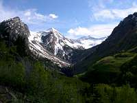
Snowmass is the 32nd highest mountain, in Colorado and the 3rd highest in the Elk Range. Castle Peak is the only 14er in the range that is easier to climb then Snowmass. This say's a lot for the 14ers in the range considering Snowmass is a class 3 climb. All the rest of them are far more difficult and dangerous to climb.
Snowmass is also one of Colorado's most remote 14ers. Only San Luis Peak, Windom Peak, Eolus Peak and Sunlight Peak are more remote. The Shortest trail to its base is 8.4 miles. Snowmass cannot be seen from any roads or towns.
There are several different routes up the mountain and they are all class 3. The Peak is a boulder that stands about 5 or 6 feet high. Snowmass is a spectacular mountain. It has a huge snowfield on the east side, which is one of Colorado's largest snowfields. The thin knife-edge ridges leading to the summit jet up about fifty feet from its slopes. The rocks look like spears coming up out of the earth. Following the tops of the ridges is a very exposed, dangerous, long and tedious process. These rocks are often no more then a couple of feet wide. The thin ridge leading to Capital Peak is very impressive.
USGS has resurveyed the elevation. The new elevation is 14,099 feet.
Snowmass is a very steep mountain on all sides. There are no easy ways up and can be dangerous to climb and even deadly. Special care should be taken knowing your route before heading up it.
For further discussion on this click here
 |
 |
 |
 |
 |
Getting There
There are a few different ways to get to this mountain. Some make for really great multi-day backpacking trips, and some are very direct. The Snowmass Creek Approach is the most direct way of getting there.
Typically people get to this mountain from the north, but from Crested Butte, heading over Schofield Pass makes for a really good Backpacking trip. This route can take you 5 days total. It really depends on whether you just want to get in bag the peak and get out, or to take you time enjoy the area and take a few extra days.
Some of the Approaches are:
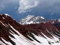
Snowmass Mn seen along the way to Snowmass lake
Snowmass Creek Approach
This approach is 8 miles to Snowmass Peak. Start at the Snowmass Creek Trail head. Take the Maroon-Snowmass Trail.

Snowmass seen from Buckskin Pass
Buckskin Pass Approach
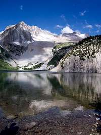
This approach is a little shorter, but more strenuous. Start at the Maroon Lake Trailhead. Take it for 1.5 miles to the east end of Crater Lake. Turn right and take the Maroon-Snowmass Trail North west over Buckskin Pass (12,462 feet). Cross Snowmass Creek then Climb northwest to Snowmass Lake.

Snowmass Mountain and Hagerman Peak
Lead King Basin Approach
This is the shortest approach to reach Snowmass Mtn. Start at the Crystal Trail head and walk up the 4WD road for about half a mile. Turn north at a junction and follow the road into Lead King Basin. Cross to the river's west side to the parking area above the trail head. Take the Geneva Lake Trail. From Geneva Lake you can take Trail Rider Pass to get to Snowmass Lake.
Snowmass Mtn seen from Frigid Air Pass
Schofield Pass Approach:
This Approach is often called "The Four Pass Loop." It requires hiking over two, 12,000 foot passes either direction. The best way of doing it is taking a 5-day trip and hiking over all four, 12,000 foot passes. This route offers the opportunities of bagging two other 13ers, Buckskin Benchmark and Mount Belleview. This route gives you a wonderful tour of the elk range, completely hiking around the Maroon Bells.
From Crested Butte drive over Schofield Pass to the trail head just north of the pass. Hike up East Fork to Frigid Air Pass, then descend down to North Fork. Then hike up to Trail Rider Pass and drop down to Snowmass Lake. Heading back you can go the same direction or Hike over to Buckskin Pass and down to West Maroon Creek. Then hike over West Maroon Pass back down to East Fork.
Red Tape
Several Colorado wilderness areas now require a free user permit to be in the wilderness, or shortly will require same. The wilderness areas are Holy Cross, Maroon Bells/Snowmass, Mount Evans, and Mount Massive. Permit tags are available at trail heads and are a two part tag. The white part goes in the box provided and the card portion is to be attached to the outside of your pack. There is currently no penalty if one does not have a permit. However, large fines could be levied within a few years for non-compliance. The preferred method now for dealing with violations is education of the users.
The reason for implementation of this required permit is the Forest Service has been unable to obtain accurate data on use patterns from the voluntary sign-in system. The estimated compliance range is currently 10-30%.
The hope is to obtain better data with this new method. While some may feel this is a precursor of some kind of quota system, the opposite is actually true. Accurate information on visitor use patterns will allow the forest service to attempt to evenly distribute impacts and encourage use of alternate trail heads for the same destinations. However, given the magnitude of the state's continuing population boom, folks should not be surprised if quotas in certain areas become a necessity.
Thanks to SP member mtnhiker13 for supplying this vital update via the Colorado Mountain Club's email service.
Specific information can be viewed here.
When To Climb
June-Sept are the typical months to hike Snowmass Mountain. Hiking this peak in winter is not unheard of.
Camping
The most popular way to hike this mountain is backpacking, so camping is highly recommended. This is an extremely long hike if it's done in a single day. Camping within 100 feet of the lake is not allowed. Weekends can be quite crowded. No fees.
Mountain Conditions
Summer Months are typical for Colorado. More then likely it will be clear in the morning and and cloudy in the afternoon. Get an early start, You don't want to be on the mountain if a thunderstorm starts. Be off the mountain by the afternoon.
PeterD. - Feb 9, 2002 7:12 pm - Hasn't voted
Untitled CommentThe better and more scenic route is from the west, via Lead King Basin. This route starts at Crystal, goes up a jeep trail, goes past Geneva Lake, and up the cliffy but negotiable west side of Snowmass. It can be done in one day, and is much less travelled than the overused eastern approaches. On a sunny August day this trip is beautiful and not soon forgotten
Aaron Johnson - Jun 27, 2005 9:58 pm - Voted 10/10
Untitled CommentSeveral Colorado wilderness areas now require a free user permit to be in the wilderness, or shortly will require same. The wilderness areas are Holy Cross, Maroon Bells/Snowmass, Mount Evans, and Mount Massive. Permit tags are available at trailheads and are a two part tag. The white part goes in the box provided and the card portion is to be attached to the outside of your pack. There is currently no penalty if one does not have a permit. However, large fines could be levied within a few years for non-compliance. The preferred method now for dealing with violations is education of the users.
The reason for implementation of this required permit is the Forest Service has been unable to obtain accurate data on use patterns from the voluntary sign-in system. The estimated compliance range is currently 10-30%.
The hope is to obtain better data with this new method. While some may feel this is a precursor of some kind of quota system, the opposite is actually true. Accurate information on visitor use patterns will allow the forest service to attempt to evenly distribute impacts and encourage use of alternate trailheads for the same destinations. However, given the magnitude of the state's continuing population boom, folks should not be surprised if quotas in certain areas become a necessity.
Thanks to SP member mtnhiker13 for supplying this vital update via the Colorado Mountain Club's email service.
Specific information can be viewed here.