
|
|
Mountain/Rock |
|---|---|
|
|
39.12310°N / 106.9741°W |
|
|
13336 ft / 4065 m |
|
|
Maroon Creek Valley Overview
The colorful Maroon Creek Valley may be Colorado’s most beautiful mountain scenery accessible by car. It is certainly the most photographed mountain scenery. For photographers and climbers, the obvious area trophy peaks are the famous Maroon Bells and Pyramid Peak. Both massifs are well known and well deserving of any recognition and accolades they receive.
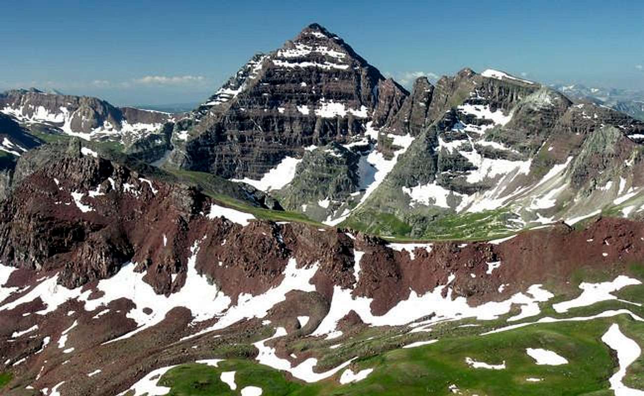
What about all of those other peaks residing in the Maroon Creek Valley? Other nearby mountains include Belleview Mountain and Buckskin BM, UN13,336 and UN13,039, Sleeping Sexton, Thunder Pyramid, and Willoughby Mountain. Some occupy space along the Maroon Creek Drainage with the two big fourteeners. Others reside in the pristine Willow Lake area; a place that resides directly north, 2000-ft above the tourist laden Maroon Lake. All of these mountains are officially ranked thirteeners with stunning views.
It makes sense that other nearby mountains boast even more of that beautiful sedimentary rock left behind from the Permian Age; beautiful to look at but a pain in the… to hike or climb on. For climbers, it’s the classic double-edged sword: sort of a love/hate relationship. First, we bow mercifully for the plentiful tundra it left behind and next we find ourselves cursing the crappy handholds. Second, we eagerly applaud that red, silky silt for its flowery lushness and next, we secretly pray that a nearby mountain goat selects a route anywhere but directly above our heads.
UN13,336 Overview
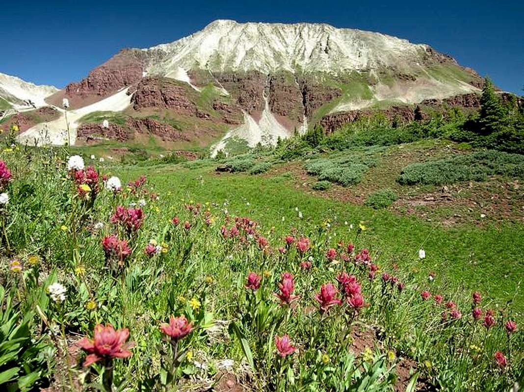
From Willow Lake, the view of UN13,336 or "Willow Peak" is nothing short of the word “stunning.” I still can’t fathom why this mountain is not officially named; it may be the most beautiful mountain I have ever climbed. On a sunny spring day, expect an explosion of brilliant colors. The view is complete sensory overload. Stay away from the polarizer when taking photos up there unless you want shots of Dorothy and Toto dancing down the yellow brick road.
UN13,336 is a prominent mountain that shares a connecting ridge with the more popular Buckskin BM. The mountain is horizontally split in half with two different types of geology. The bottom half is the red sedimentary rock of the Maroon Bells and the upper half is the whitish, fractured rock of nearby Capitol Peak. The west and east faces are ribbed with steep gullies that descend from the upper half to the lower half of the mountain. The color contrast from the white talus run outs within the red lower half of the mountain makes for some very cool scenery.
Maroon Creek TH at 9,590-ft
Approach "Willow Peak" from the Maroon Lake TH (9,590-ft.) From Aspen, locate a roundabout a half-mile north on Hwy 82 and drive west on Maroon Lake Road for 9.4 miles to the parking area.Starting June 14,2008 Maroon Creek Road restrictions will start and visitors will be directed to RFTA bus service. Buses from Aspen Highlands arrive at Maroon Lake every 20 to 30 minutes. All day users will be required to ride the bus between 9 a.m. and 5 p.m. The bus fare is $6 per adult and $4 per senior and child.
Call RFTA at 970-925-3445 or the White River National Forest at 970-925-3445 for schedules.
Author: big_g
Date: Aug 08, 2005 8:19 PM
The road up to the trailhead is restricted to day trippers only. Backpackers and climbers are welcome to drive up (in case they need to exit due to emergency after the shuttle service has stopped).
No promises that you'll find a spot at the end of the road, but you should be able to find something at either the East or West Maroon Wilderness Portals. The bus can be flagged down anywhere to take you the rest of the way.
The following was updated 6-30-2005 by Aaron Johnson
Several Colorado wilderness areas now require a free user permit to be in the wilderness, or shortly will require same. The wilderness areas are Holy Cross, Maroon Bells/Snowmass, Mount Evans, and Mount Massive. Permit tags are available at trailheads and are a two part tag. The white part goes in the box provided and the card portion is to be attached to the outside of your pack. There is currently no penalty if one does not have a permit. However, large fines could be levied within a few years for non-compliance. The preferred method now for dealing with violations is education of the users.
The reason for implementation of this required permit is the Forest Service has been unable to obtain accurate data on use patterns from the voluntary sign-in system. The estimated compliance range is currently 10-30%.
The hope is to obtain better data with this new method. While some may feel this is a precursor of some kind of quota system, the opposite is actually true. Accurate information on visitor use patterns will allow the forest service to attempt to evenly distribute impacts and encourage use of alternate trailheads for the same destinations. However, given the magnitude of the state's continuing population boom, folks should not be surprised if quotas in certain areas become a necessity.
Thanks to SP member mtnhiker13 for supplying this vital update via the Colorado Mountain Club's email service.
Specific information can be viewed here.
Maroon Bells Snowmass Wilderness
See Getting ThereMaps: Maroon Bells, White River National Forest
Aspen Ranger District Office
(970) 925-3445
USDA Forest Service
White River
National Forest
P.O. Box 948
Glenwood Springs CO 81602
Forecast for the Maroon Creek area
Click image to enlarge
Click here to view a 7-day forecast for UN13,336
