
-
 11265 Hits
-
 89.32% Score
-
 29 Votes
|
|
Mountain/Rock |
|---|---|
|
|
44.35250°N / 109.9471°W |
|
|
Hiking, Mountaineering, Sport Climbing, Scrambling |
|
|
Summer |
|
|
10798 ft / 3291 m |
|
|
Overview
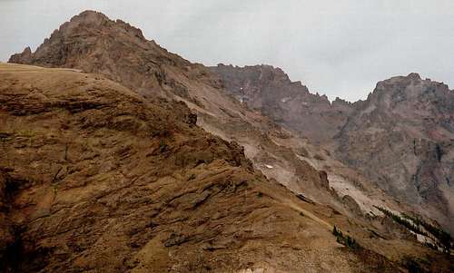
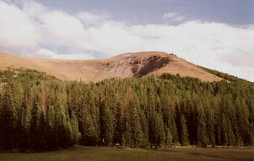
Eagle Nest fits its alluring name perfectly. Like an eagle’s aerie, it soars over its surroundings and commands sweeping views in all directions. Also like an eagle’s aerie, it is a difficult summit to attain.Eagle Nest is a perfect mountain for mountaineers who seek the following three things all in one: solitude, deep wilderness, and a challenging climb. Located in a quiet section of the already-quiet Washakie Wilderness in Wyoming’s incredibly wild Absaroka Range, this flat-topped, crumbling crag overlooks the meeting of eastern Yellowstone’s Thorofare region with the Teton and Washakie Wilderness Areas, an area that by some measures is the most remote in the Lower 48. This mountain, which is not visible from roads, will compel you, perhaps even frighten you, when you see it. And even though nearby Howell Mountain is higher, Eagle Nest, a far more rugged peak, dominates the area and issues a siren song while Howell stands meekly and silently by.
Nearby UN 10,425, going by the “Colorado Rule” for prominence, is not an official peak but is rather a gentler sub-peak along the north ridge of Eagle Nest. If skill or nerves fail you (or if good sense prevails) and you cannot climb Eagle Nest itself, UN 10,425 makes a nice consolation prize. For reasons I discuss on the route page, I did not climb all the way to the summit of Eagle Nest, but I did summit UN 10,425.
This is a mountain I visited before I knew about SP. Weather conditions didn’t let me take many good pictures, and so I threw out most pictures and negatives from the trip. I reprinted the entire strips for those I did save, but some of the pictures are not very good (though I hope they’re at least useful). I apologize in advance, then, for the submission of pictures I normally would not show. I actually had better “bad pictures” on the negative strips I tossed.
Getting There
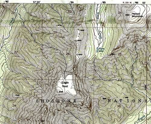
U.S. 14/16/20 connects Cody and the East Entrance of Yellowstone National Park. Theodore Roosevelt once characterized the stretch between Wapiti Valley and Yellowstone as being the 50 most beautiful miles in America. I can think of a few roads I think are more scenic, but this trip paralleling the North Fork of the Shoshone River is still no slouch. Between Wayfarers Chapel and Chimney Rock (getting the USFS map for the north half of Shoshone National Forest would be a good idea), look for an unpaved road heading south. It crosses the river almost immediately, and almost immediately after that there is a fork. FR 446, the left fork, leads about two miles to a scout camp. The other fork, FR 448, is the one to take. This road, passable to passenger vehicles, continues south for a few miles until it reaches a gate and a tiny parking area (room for maybe three or four cars) just where the road turns right to enter a subdivision. This parking area is the trailhead for Forest Trail 757, which follows Kitty Creek and later Neva Creek through Paradise Valley and ultimately to Flora Lake.NOTE: When I was there in 2001, there were no signs directing people to the trailhead or informing them they were there once they were. Also, the location of the trailhead didn’t fit with the directions in the Falcon Guide I had with me at the time. It was a local resident who confirmed that I was at the trailhead, and it seemed that the trailhead had been relocated a mile or two north from where it had been before. This made what the book described as a 6-mile hike to Flora Lake more like 8 miles. Fortunately, my wife and I were there to backpack, anyway, but this is useful information for anyone wanting to try Eagle Nest as a day trip, which I do not recommend.
For five or six miles, the trail is pretty uneventful and mostly passes through a dense lodgepole pine forest, but there are occasional views of nearby mountains, and the stream is often close by. The trail is moderate in grade and shouldn’t have you worn out by the time you reach its end, not if you’re in decent shape, anyway. When the trail reaches Paradise Valley, things open up, and you find yourself strolling through the kind of subalpine, flower-filled meadows common in the Wyoming Absarokas. You’re not above treeline here or anywhere else along the trail, but the valley is wide enough, and the rolling mountains flanking it high enough, to lend an alpine feel to the setting.
Finally, after going back into the trees for a bit, the trail opens up for good and reaches tiny Flora Lake, across which you can throw a rock. Flora Lake is less a tarn and more a water-filled depression in a grassy meadow. But it makes a nice destination for a few reasons: it sees little traffic and is in the heart of some real wilderness; gentle ridges (Eagle Nest’s being exceptions) beckon hikers to enjoy some solitary, unforgettable views of some of the wildest country in the U.S.; it is itself in a scenic, relaxing area that makes a wonderful antidote to everyday life; and, even if you have no intention of straying from the trail, you can hike to the top of the rise just a few feet south of the lake and enjoy a view deep into the wild, rugged mountains from Pinnacle Mountain to Glacier Basin, areas that have no trails and see almost no human traffic--- what wonders await the bold and the prepared out there may defy imagination.
Flora Lake is at 9800’, and the summit of Eagle Nest is about a mile and just 1000 vertical feet away. But don’t expect the climb to be quick and easy. Expect at the minimum low Class 5 climbing and some very loose rock. When I tried the mountain in 2001, I had no knowledge of class ratings, but the moves I remember making fit with those I have made on 5.0-5.4 routes, only the rock on Eagle Nest was worse.
Please see the attached route pages for more information. Also, if you want to add, edit, or adopt a route page for the peak, please do so or PM me, whichever is more applicable.
Red Tape
No human-generated red tape, but remember that this is prime grizzly habitat. The Yellowstone Ecosystem is one of America’s iconic grizzly haunts, and the Absaroka Range has more of the great bears than any other range in the area does.Know proper food storage techniques, of course. Also, know how to act if you encounter a grizzly—back away slowly but don’t turn your back and don’t make eye contact, and speak loudly but calmly. If charged, drop and curl up, doing your best to protect your abdomen and head (and make peace with your God). If the bear starts mauling you as opposed to poking around, fight back. What do you have to lose at that point?
Carrying pepper spray, available in local sporting goods stores, is a good idea if you know how to use it.
And don’t forget that black bears can do a number on you, too. Many people discount them in grizzly territory, but there are more problems with black bears than there are with grizzlies.