
-
 13141 Hits
-
 89.39% Score
-
 29 Votes
|
|
Mountain/Rock |
|---|---|
|
|
43.74949°N / 110.03806°W |
|
|
Mountaineering |
|
|
Summer |
|
|
10537 ft / 3212 m |
|
|


First of all, let me say, just for my own sense of CYA, that although this is not a big mountain and climbing it is a matter of a few hours, it would be very easy to get yourself badly hurt or killed while climbing this peak.
The reasons why:
• The exposure can be severe.
• The rock is more than just loose; the mountain seems to be falling apart, and it is in the worst condition of any mountain I have ever climbed.
• Unless I am sorely mistaken, there are no safe ways to protect a climb up this mountain, due to the rock conditions. In fact, roping up on this peak is probably riskier than going unroped.
So it's no K2, but it's still a handful. If you're okay with all that, then read on, because this is one hell of a great little mountain to climb. If you like exposure and rotten rock and Class 4/5 climbing without roping up, then I've got a mountain for you.
If you're not okay with all that, please still read on, for there is a walk-up/walk-off route that I used for my descent, and there are details about it in the Route Information section.
Overview
Sublette Peak is neither a big peak nor a major peak in Greater Yellowstone; if it weren't so prominently visible from the popular Wind River Lake pullout near Togwotee Pass, the number of people who have even seen or thought about this peak would be much lower than it already is.
But it is prominently visible from that pullout, and it appears from there as a striking pinnacle that, despite being dwarfed by its higher neighbor, Mount Sublette, probably gets the lion's share of cameras pointed its way. Sublette Peak looks good from all angles, actually, but the perspective from Wind River Lake is probably the most interesting road-accessible one. It must be difficult to see the peak and not want to climb it.
Sublette Peak is typical of the Wyoming Absarokas around Togwotee Pass in these three ways:
• Even though it is only about a mile from a paved road, just a few minutes of hiking to it takes you into breathing, pulsating wilderness.
• The views in all directions from up high will easily divert your attention from the visible paved road; you will be so drawn to the mountain scenery that you will only notice the road if you look for it.
• The rock is just awful.
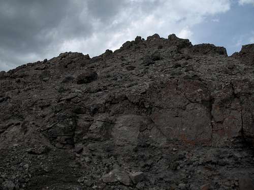
So what's the deal with the rock? The upper mountain consists of breccia, which is rock composed of other rock fragments that have been cemented together by hardened volcanic ash. Though it sometimes is stable, breccia is often hideously loose even though it is beautiful to look at, as it often forms spectacular cliffs and spires. The rock often looks like a knob-studded conglomerate seemingly made for climbing, but those knobs pull out easily and frequently, making climbing on them treacherous. Some hardened Wyoming mountaineers refer to the substance as "kitty litter." The name fits, as anyone who has climbed on it can surely attest.
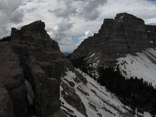
The summit of Sublette Peak offers outstanding views of Two Ocean Mountain, Mount Sublette, Brooks Lake and the Pinnacle Buttes, and the alpine plateaus and peaks deep in the Teton Wilderness.
What's in a Name?
The name Sublette is all over Wyoming. The reason seems to be William Sublette, a mountain man, fur trader, and explorer. Sublette did a number of things to make himself memorable in Wyoming, but perhaps most relevant to this page is the fact that he was one of the original white men who "discovered" the geysers of Yellowstone.
Getting There
There are two places from which one can access the peak.
The first, and the closer to the peak, is at Wind River Lake, which is about half a mile east of Togwotee Pass, on the north side of the road. There is a picnic ground and a pit toilet here. A trail follows the left (west) side of the lake and seems to disappear in the meadows at the upper end of the lake, but it is possible that the trail continues to the saddle between Mount Sublette and Sublette Peak and was just buried under the many snowbanks present when I climbed the peak.
The second access point is at Brooks Lake. About 7 miles east of Togwotee Pass on U.S. 26/287 northwest of Dubois, turn onto the road for Brooks Lake and follow this good unpaved road for 5 miles to the lake.
There is an unpaved road connecting Wind River Lake with Brooks Lake, and it cuts off some driving distance incurred by following the highway and the signed turnoff, but it is recommended for high-clearance vehicles and is probably impassable when wet. When dry, though, most regular cars can manage it if driven with care. It is about 6 miles long.
About half a mile from Wind River Lake along this road, there is a pullout on the north side of the road (this pullout is pictured in this page's gallery). Back in 2007, I thought I noticed a trail heading off into the woods from this pullout. It is possible-- not guaranteed-- that the trail connects to the saddle between Mount Sublette and Sublette Peak, which would make the approach from Wind River Lake quite a bit easier.
Climbing Route
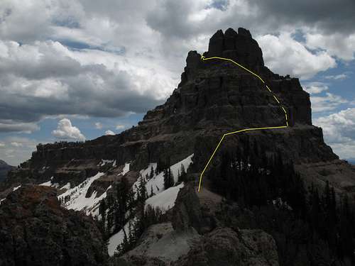
Click for details.
From Wind River Lake, the distance to the summit is about 2 miles, with about 1000' of elevation gain, with most of that in two distinct sections: the summit cliffs and the climb up to the saddle northwest of the peak.
From Brooks Lake, it is about 2.5 miles to the summit, with an elevation gain of about 1500'.
The climbing in the summit area will be exposed and extremely loose. You will encounter climbing in the Class 4 to 5.3 range no matter what chimney, gully, buttress, etc. you try. You probably cannot protect your climb, and if you plan to descend the same way, you must take extra care not to knock rocks loose from the difficult sections, or you may substantially increase the difficulty of your descent. For that reason, I recommend using the alternate route for your descent; it is safer, and you get a fuller tour of the mountain.
Approach
From Wind River Lake, follow a trail along the left (west) side of the lake until the trail peters out and then hike/bushwhack your way to the saddle between Mount Sublette and Sublette Peak. At the saddle, you will see a trail coming up from the other side and dropping down yours, suggesting that there is a link to the alternate trailhead described in the Getting There section. It is about 1.5 mi from Wind River Lake to the saddle.
From Brooks Lake, hike through the meadows and then through the trees until you reach another section of meadows, where a trail (not shown on USGS maps) leads to the saddle. This distance is about 2 miles.
From the 10,000' saddle, scramble up a technically easy but extremely slick dirt slope and reach a knob with an outstanding view of Sublette Peak and its surroundings. This is the rise at 10,200' shown on the topo maps. Now start studying the peak and wonder if this is your lucky day. After you've identified a preferred route and some alternates, head on. Ahead of you is only some 400' of vertical climbing, but it's some of the worst 400' of rock conditions you'll ever face.
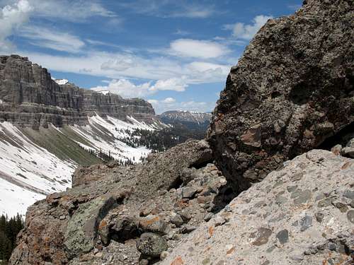
Brittle breccia
Climbing
I really can't describe the route I found up. I also don't have pictures of it. Why?
• I never expected to get up the peak and therefore wasn't climbing with a route description in mind. The day of my climb was actually my second attempt at the peak; the first was in 2007, but my climbing partner and I bailed because of the combination of the rotten rock and poor weather that prevented us from seeing much more than 30 feet above us. So the day I climbed the peak, I was really just intending to get a better look at things and scout out the walk-off route someone had once told me about.
• During the course of the climb, I had to backtrack several times and try something else; it was enough remembering where I'd just been without worrying about being able to recall every aspect of the climb.
Here's what I can tell you: on my first attempt, my climbing partner and I focused on ways up the northern side. On my return trip, after looking at the northern side and concluding a climb up it was not a great idea, I focused on the western side, and it was there that I ultimately found some gullies, faces, and breaks that suddenly landed me on the north side almost within spitting distance of the summit. From there, a short, airy traverse took me to a snow-filled notch that I climbed to reach the summit ridge just a short distance from the summit itself. From there, it was a quick clamber to the small summit cairn, where there was not, as is typical of Wyoming peaks, a register.
Summit
Alternate Route
This entails a hike along a road (Class 1, obviously, but watch out for the ATV people) and then a combination of hiking, bushwhacking, and clambering (Class 2 with the possibility of Class 3-- if it gets harder than that, look for something easier).
Approach
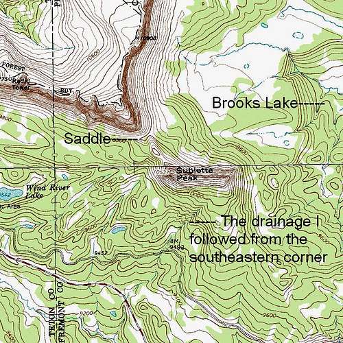
From the south side of the peak, you want to get up to the eastern end of the long summit ridge. The best place to start is from somewhere along the dirt road between Wind River Lake and Brooks Lake. I used this route for my descent and found a (mostly) snow-filled drainage that took me from the trees all the way to the road. In this page's gallery is a picture of the spot where the drainage met the road; it was about 1.5 mi from Wind River Lake.
Route Details
Make sure you are aiming for the eastern end of the summit ridge; as you get closer to the western end and the summit, the cliff bands get higher and steeper to the point of being unclimbable. With luck and/or good planning, you can make the ridgetop with just Class 2 going.
Hike the ridgeline west until you reach the summit. You may encounter some short scrambling sections, but things never need to get harder than easy scrambling. The last stretch to the summit itself is Class 2+, meaning you may use your hands to steady yourself but are not using them for actual holds.
From the summit back to Wind River Lake, my descent route was 2.3 miles.
Topo Map
Red Tape
Nothing official pertaining to the mountain. Do be aware that this is grizzly country and that special behavior and precautions are in order.
Camping
The Falls Campground is located about 10 miles east on 287; it is a large CG with 80+ sites, and the sites fill first-come, first-served. Two smaller, prettier campgrounds are slightly longer drives away; take the well-signed turnoff for Brooks Lake and drive 5 miles to the Brooks Lake and Pinnacles Campgrounds. These campgrounds are also first-come, first-served, and they have around 20 sites each. Even on summer weekdays, the sites often fill by early afternoon, as the area is very popular with anglers.
Sleeping in your car at Wind River Lake is also an option.
More Information
Shoshone National Forest