
-
 5870 Hits
-
 84.27% Score
-
 18 Votes
|
|
Mountain/Rock |
|---|---|
|
|
37.19639°N / 112.94737°W |
|
|
Scrambling |
|
|
Spring, Fall, Winter |
|
|
6600 ft / 2012 m |
|
|
Overview
Not named on maps and probably not in any guidebooks (it was in an excellent guidebook that now is out of print), Gifford Peak, so named because it overlooks Gifford Canyon (which is east of the peak), is one of a series of [officially] unnamed peaks due south of the Zion-Mt. Carmel Tunnel.
Gifford Peak is among the obscure peaks on the east side of the park. Because only one peak east of the Zion-Mt. Carmel Tunnel and not considered part of the Zion Canyon group-- Checkerboard Mesa-- has a name on USGS maps, and because there are only two officially maintained trails originating out there-- Tunnel Overlook and East Rim-- the east side is Zion's flyover country, so to speak; the majority of visitors are people on their way to or from Zion Canyon, and they do little more but stop and wander a few yards from the roadside to take some pictures. Thus, the east side, with its many unnamed peaks and its numerous washes and canyons, is a haven for scramblers and explorers who delight in isolation and secret wonders. In addition to all the peaks, there are several small slot canyons of varying difficulty levels, including Keyhole Canyon, a dark, very narrow technical slot.
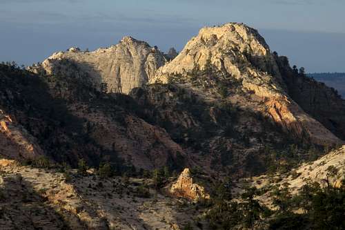
Gifford Peak and Destination Peak
Few people see Gifford Peak. For people on foot, it's really only visible from other summits in the area and from the approach for the scrambling route on Bridge Mountain; people doing the latter actually pass quite close to Gifford Peak, but the route on Bridge Mountain is an all-day affair (and the exposure, complicated route-finding, and Class 4 terrain help keep the numbers low, anyway), and thus almost no one adds Gifford or any of its neighbors either coming or going.
If few see it, even fewer climb it. When I left the summit in April 2014, the register had only 7 party entries, including mine (mine was a party of one). I know that at least one other party has climbed the peak, that being the first ascentionists, who climbed it not long before the register-placer-- a local legend by the name of Joe French-- made it up. It might (or might not) be of interest to know that the first people to climb the peak included some prominent SummitPost members. So it's probably safe to say this peak had seen fewer than 10 ascents as of the time I posted this page.
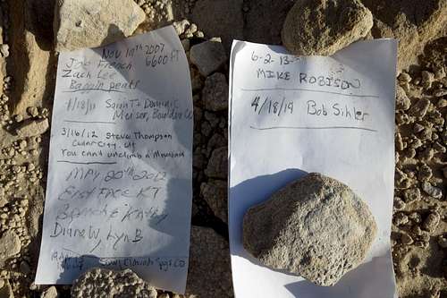
Summit Register
Although the route up is not a truly hard one, it's not a mere stroll, either. RT distance is about 6 miles, with around 1500' of elevation gain. Don't be fooled, though; almost all of the elevation gain comes after the first mile. There's some Class 3 and 4 on the approach, and a little Class 3 on the summit route itself, but the crux is a short pitch (without the scary exposure that means a long fall before death) that will go at 5.0-5.4 depending on the current conditions (see route description for details).
Views from the summit are among the best, if not the best, I have ever beheld from a Zion peak. For that reason, I have not included any summit views on this page or in its gallery. If that sounds strange and contrary to the purposes of a page like this one, consider this: in my opinion, showing the rare and hard-earned views on the Internet would diminish the satisfaction coming from seeing them for real. Should anyone ever use this page as a resource for climbing Gifford Peak, I'd like that person to behold those views and say "Wow..." instead of "Oh yeah, that's what I saw on that guy' page!"
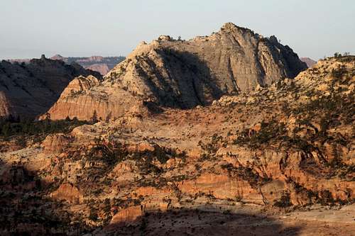
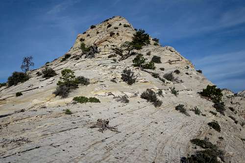
Gifford Peak, with almost the entire summit route visible
Getting There
From Zion Canyon, drive the switchbacks up to and through the Zion-Mt. Carmel Tunnel. Immediately after exiting the tunnel, turn right into a small parking lot.
If you are coming from the east, things are a little more complicated. You can't legally make a left turn into the parking lot, and for much of the day there is a ranger there to monitor things, so you will have to park in a nearby parking lot or pullout on the right side and walk a bit.
Go early or late. After 8 A.M., traffic control for the tunnel begins, and it's one-way traffic every time an oversized vehicle (RV) has to come through. Also, the lot just east of the tunnel is typically full between 9 and 5.
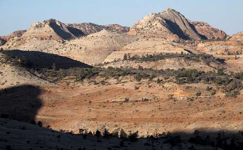
Hepworth Peak, Jenny Peak, and Gifford Peak
Route
Because this is an obscure peak that has seldom been climbed, I am going minimalist with the route details. There are no route photos or diagrams. Should you feel that my description, along with a good topo map, is insufficient, please find a different peak to climb.
From the parking area, drop into the wash below. This is Pine Creek, which quickly becomes a technical slot if you head downstream. If you head upstream, you will go through some nice narrows and eventually will be able to scramble out across the road from the overflow parking area for the Canyon Overlook trail; this parking lot is the closest one to the tunnel on the north side of the road.
Find a use trail or your own way up out of the wash and then down into Gifford Wash. Head up mostly sandy Gifford Wash for about a mile until you see an area with a waterfall (most likely dry) and slabs on the waterfall's right side.
Work up the slabs and find your way into a slickrock bowl. Ascend the bowl to a brushy, sandy bench overlooking Gifford Peak to the left and Destination Peak to the right. The going up to and through the bowl is likely to be Class 4 in places and even harder depending on your exact route. You might find cairns to steer you, but don't count on finding them and don't go out looking for them.
From the bench, head to Gifford's northeast ridge. You'll have to descend a little, though not too far, in order to gain it.
Once on the ridge, follow the easiest ground to the summit.
The crux is a 15-20' wall. There may be a dead tree leaning against it. If there is, and if the tree is still solid enough to bear weight (it was in April 2014 but was close to being rotten enough to merit avoiding), then walking up the tree and then climbing the wall the rest of the way is about 5.0. But if the tree is gone or too rotten, then the wall is going to be 5.2-5.4. And it is unprotectable.
(Returning, you can rappel from a short but sturdy tree; a 50m rope is plenty.)
A little Class 3 route-finding gets you atop the summit block. Enjoy-- only a handful of other people have been here before you.
Summit Block of Gifford Peak
Descent: Most will just go back the way they came, but those up for a little adventure may like to know that shortly after rapping the crux, I left the ridge and found a more direct and more challenging way back down. For this, you would want a 60m rope for a rappel, though I note that with care one can avoid that rappel, which appears just when you start to believe this way will go and far enough down that you will detest the idea of heading back up. This different way back down landed me by the waterfall in Gifford Canyon a short distance "upwash" from where I left the canyon earlier to climb the peak, and it added some nice scenery and variety to the day.
Red Tape
$25 entrance fee for Zion these days. You can save $ in the long run by buying an annual pass or interagency pass if either suits your needs.
When to Climb
Best fall through spring. If you climb it in the summer, start out very early. The heat will turn the surrounding slickrock into an oven by late morning.
Camping
There are no campgrounds on the east side of the park, but the Watchman Campground, near the Visitor Center, is not far away. This campground is open all year, and you can make reservations for certain months at recreation.gov.
Less than a mile from the park's east entrance, there is a campground/RV resort right off the road, with a store and restaurant right across the street. I have never stayed there, but I have stopped there for snacks and showers, and the staff have been very friendly.
External Links
More information about regulations, camping, and more: Zion NPS Site.