


-
 2672 Hits
-
 78.27% Score
-
 9 Votes
|
|
Area/Range |
|---|---|
|
|
45.71000°N / 7.47227°E |
|
|
Hiking |
|
|
Spring, Summer, Fall, Winter |
|
|
8304 ft / 2531 m |
|
|
Note
La montagna chiama i suoi figli, ed essi rispondono fedelmente al suo appello… Osvaldo Cardellina, Diario alpinistico, 1964-65 Page texts: @ OsvaldoCardellina "Osva", passed away on May 2, 2022. Page owners: Christian Cardellina e Osvaldo Cardellina. Any updates from September 12, 2022: Antonio Giani, page administrator, friend and climbing companion. Testi della pagina: @ OsvaldoCardellina "Osva", scomparso il 2 maggio 2022. Proprietari pagina: Christian Cardellina e Osvaldo Cardellina. Eventuali aggiornamenti dal 12 settembre 2022: Antonio Giani, amministratore della pagina, amico e compagno di salite. |
Lower Overview Higher
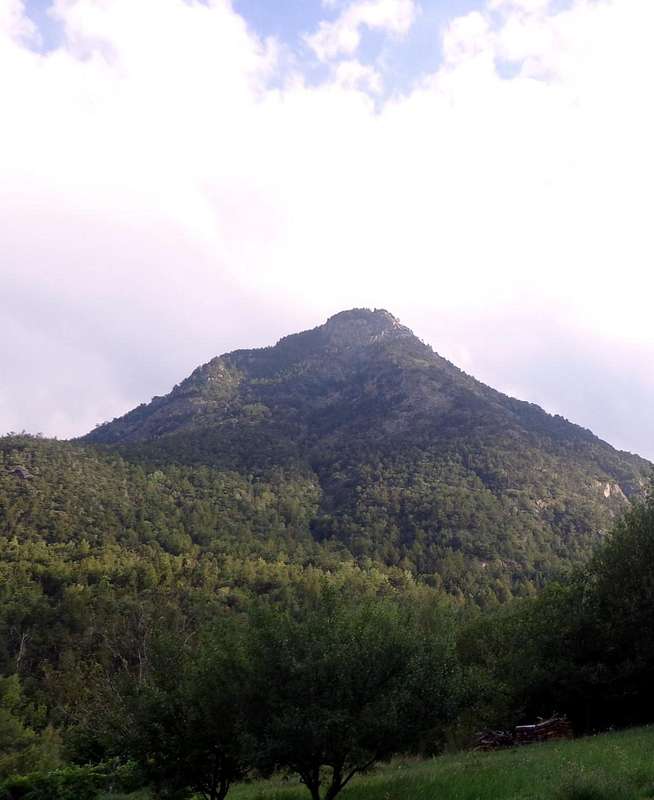
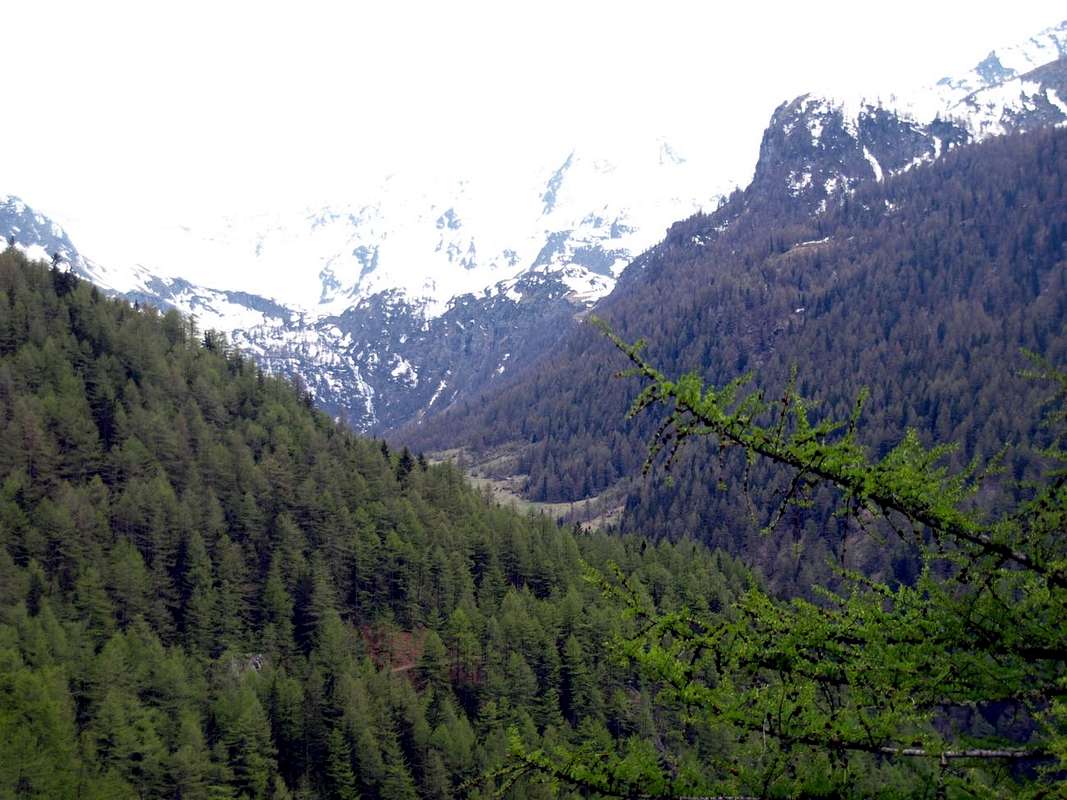
This wide wooden area dominates towards SE the City of Aosta and falls in two adjacent Commons: Fénis St. Marcel. On top of that is made up of Mont Corquet (2.531m) on the more Western of the two watersheds that contain it. In fact this Summit is more deviated from the true Vertex of the valley formed by the Punta del Tessonet (3.266m; the nodal point of a watershed ridge coming from Punta Tersiva 3.515m) where the same ends forming two well defined watershed: the West precisely what the Subgroup of Rouèses, while on the opposite stretches that of two Averts, which culminates with the Grand (2.991m) to finally finish one hand to Mont Roux (2.530m) with the Coppermines of Chuc-Servette, while on the other, always after the Mont Corquet (2.530m), the partition is extended to the North-northeast until Torrasse or Mont Touriasse (1.985m) and the rocky promontory over the forest of Mont Saint Julien (1.377m), with its Sanctuary of San Grato above the Municipality of Fénis and the Hermitage of San Giuliano perched on the cliffs that dominate the entrance into the Clavalité Tableland. This large area is unique in its development, starting from the valley floor near Saint Marcel Common with its two fraction of Surpian or Sorpian (568m) and Prayer or Prarayer (566m), but actually splits the approach road that "escapes", "cutting" almost vertically up the hill to the North; reached the small Villages of Les Druges Higher and Lower (1.600m, 1.567m); then continue just to the North-northwest reaching Dora Baltea between the Fractions of Tillier (550m; Fénis Common) and that of Valméanaz (601m; Saint Marcel Municipality), right in front of the Commune of Nus across the great River or Dora Baltea. But it is also an area rich in walks that stretch to all the Southern directions (to Sudest at La Torasse; to the South at Mont Corquet with its intermediate alps, to Sudovest to the Mines of Servette-Chuc, right at the entrance of the St. Marcel Valley); or simply for a trip to the Pic Nic Area. Equipped and easily accessible by car or with short walk. In this regard, it is not forbidden to hike on the middle mountain, starting from the underlying Hamlets of Plout Seissogne, where gorgeous mule tracks or trails date back through and amongst the dense forests. There are also good snowshoe excursions, where you can reach the typical alps through beautiful poderal roads. Furthermore, the possibility of going SE to descend into the Clavalité Vallon passing through the Tramaouail (Alp) de la Rossa.
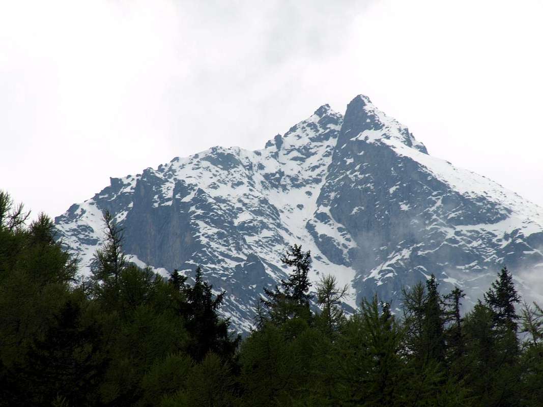
From Les Druges "Alte" towards the Little or Petite Roise Quest'ampia area boschiva domina a Sudest della Città di Aosta ed incombe su due Comuni subito uno all'altro adiacenti, ovvero quelli di Fénis e Saint Marcel. Il vertice massimo della medesima é costituito dal Mont Corquet (2.531 m), sito sul più Occidentale dei due spartiacque limitanti la medesima. In realtà questa Sommità risulta più discostata dal Vertice vero e proprio della valle costituito dalla Punta del Tessonet (3.266 m; punto nodale di una cresta spartiacque proveniente dalla Punta Tersiva 3.515 m), ove la medesima termina formando due ben definiti spartiacque: ad Ovest appunto quello del Gruppo delle Rouèses, mentre sull'opposto si allunga quello degli Averts, culminante con il Grand (2.991 m) per infine terminare da un lato al Mont Roux (2.530 m) con le Miniere di rame di Chuc-Servette, mentre dall'altro, sempre dopo il Mont Corquet (2.530 m) il divisorio s'allunga a Nord-nordest fino alla Torrasse o Mont Touriasse (1.985 m) ed al promontorio roccioso-boschivo del Mont Saint Julien (1.377 m), con il suo Santuario di San Grato sopra l'abitato di Fénis e l'Eremitaggio di San Giuliano, abbarbicato alle pareti rocciose che dominano l'ingresso nella Clavalité. Questa largheggiante area é unica nel suo sviluppo partendo dal fondovalle nei pressi di Saint Marcel, ma in realtà si sdoppia nello avvicinamento stradale che "fuoriesce" dal suo percorso naturale; infatti la Strada Regionale risale più ad Oriente di questa linea, che segue il corso del Torrente di Saint Marcel, transitando per tutta una serie di piccoli villaggi, con epicentro il Santuario di Plout, posti sulla medio-alta collina alle pendici del Mont Corquet. Anche i confini comunali con l'attiguo Comune di Fénis risultano particolari, poiché non seguono lo spartiacque ad Est, bensì dal Corquet s'indirizzano a valle "tagliando" quasi in verticale la collina verso Settentrione; raggiunti i piccoli Villaggi di Les Druges Alte e Basse (1.600 m, 1.567 m), proseguono poi appena più a Nord-nordovest raggiungendo la Dora Baltea tra la Frazione di Tillier (550 m; Fénis) e quella di Valméanaz (601 m; St. Marcel), giusto di fronte al Comune di Nus oltre il grande Fiume della Dora Baltea. Ma é anche un'area ricca di passeggiate che si diramano verso tutte le direzioni Meridionali (a Sudest a La Torasse; a Sud al Mont Corquet con i suoi alpeggi intermedi, a Sudovest verso le miniere di Servette-Chuc, proprio all'ingresso della Valle di Saint Marcel); oppure semplicemente per una gita all'Area pic Nic omonima. Attrezzata e facilmente raggiungibile sia in auto che con breve passeggiata. A tal proposito non é vietato, volendo fare un'escursione sulla media montagna, partire dai sottostanti Villaggetti di Plout e Seissogne, donde splendide mulattiere e sentieri risalgono in mezzo a fitte foreste. Si offrono anche belle escursioni a mezzo di racchette da neve, dove tramite belle strade poderali si possono raggiungere caratteristici alpeggi. Inoltre possibilità proseguendo a Sud-sudest di scendere nel Vallone Clavalité passando dal Tramaouail (Alpeggio medio-alto) de la Rossa.
Getting There
 |
 |
 |
BY CAR:
- From TORINO, MILANO, etc: Motorway A5. Exit at IVREA or Quincinetto (PIEDMONT) From IVREA Town: in West (Southern side) to Pont Saint Martin, Donnas, Bard, Champdepraz, Pontey, Fénis, Saint Marcel.
- From Fénis (537m) on Pieiller small Vallon towards Le-Pieiller-de-Sermaz, Maison Longue, Le Plany Hamlets (1.075m, 1.112m, 1.174m); through asphalt road) and subsequent connection with La Morgetta(z), Pressunettaz, alternative before Champremier (1.383m) at Les Druges Lower and Upper small Villages (1.567m, 1.600m). From Saint Marcel (630m) to Saint Marcel Vallon and Turati Reserve up to the Mulac & Grande Chaux Hunting Houses and Alp (1.937m, 2.370m). Specific Road By SS.26, 15 Km by Aosta Town, crossing the stonebridge over the Dora Baltea, just after the Country of Nus (output Motorways A5), arriving at the junction 539 meters, and immediately after the field of Football, leave the roundabout to the left on the same (various large signals), and go up to the Chief Lieu.
- From FRANCE: through the Mont Blanc Tunnel to Entrèves-crossroads to Vény/Ferret Valleys - Mountain Guides of Courmayeur - La Saxe Rock Gym - Courmayeur. By Little Saint Bernard Pass, closed since November until half May to La Thuile Valley - Pré Saint Didier - Courmayeur. It is not necessary to take Motorway A5: you can drive on SS.26, in the direction of AOSTA - IVREA - TURIN.
BY PLANE:
- Aeroporto "Corrado Gex" Saint Christophe (Aosta).
Specific Main Road towards Les Druges Area at the beginning of the paths:
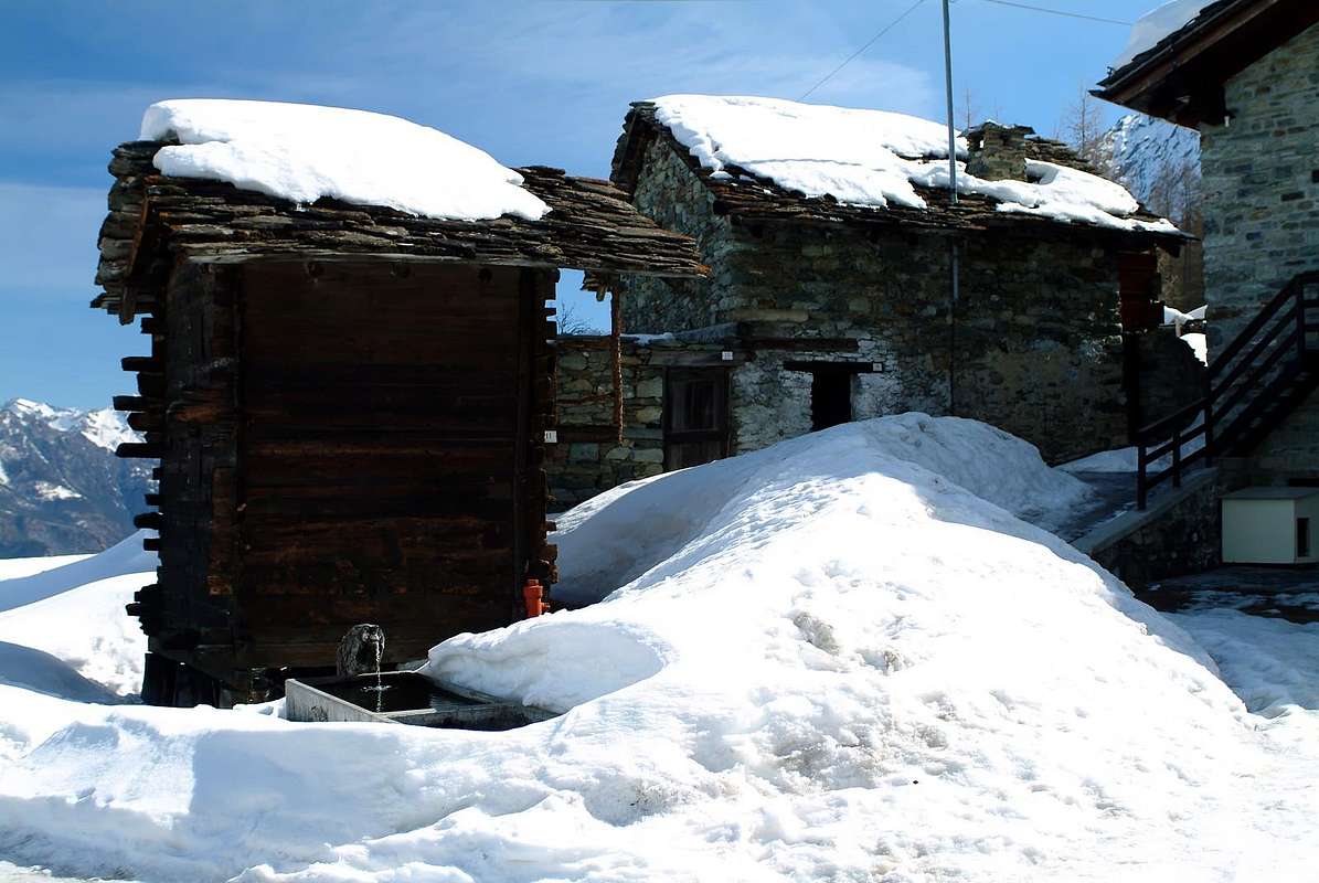
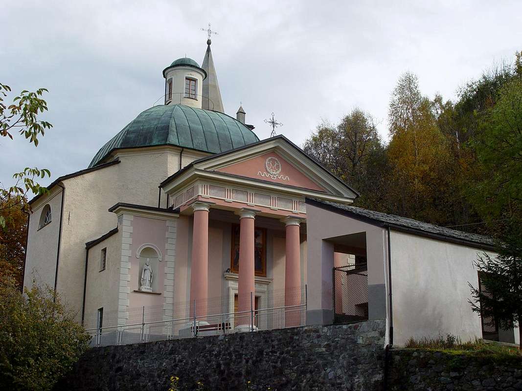
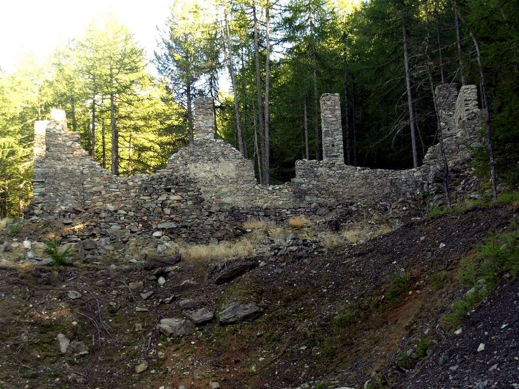
from the rotunda to the entry of the St. Marcel Municipality, to go up over on a wide bridge the Dora Baltea, bringing himself in the center of the same in direction of his great Church; to edge it and to continue (manifold indications for which thing, with the purpose not to be wrong, to follow the poster of brown color with the wording Plout Sanctuary. To go up again toward South with the Regional Road towards the Hamlets Crétaz (653m) and then, decidedly towards East, Jayer (693m) and Mezein (793m); immediately after this point, leaving on the left a ramification that goes down to the Municipality of Fénis (prohibition of transit for the cars), the road changes completely direction toward Southwest to reach the Village of Réan (898m) and, through a long diagonal, the famous Sanctuary of Plout (898m; * splendid "Via Crucis" in the covered communication trench and before), where from centuries a procession happens departing really from St. Marcel. Doubling it same the road is again addressed to thin East to a wide hairpin-road, where it reenters towards the preceding direction reaching the Village of Seissogne (1.066m) and, through great grasslands, the following one of Sazailland (1.220m); they follow those of Ronc (1.359m), Viplana (1.346m), Champremier (1.383m), over which he leaves on the left a deviation for the tall alpis of the Municipality Fénis (passable and open to the traffic) to reach the fork for Porteron (famous for his international footstep of the sled) and the following place of Leycher (1.506m; famous "Inn of the Devil"). Returning to East, the road leaves in low the short deviation for the small Village of Les Druges "Basse" (Lower; 1.567m) to reach later immediately to the next Upper Les Druges (1.600m about; beautiful fountain near a small square wooden "rascard" and votive small Chapel dedicated to St. Bernard, at the beginning of the path n° 14 to Fontanafreida Alp (1.810m).
Strada Regionale Specifica verso l'Area di Les Druges all'inizio dei sentieri: dalla rotonda all'ingresso del Paese di St. Marcel, scavalcare su d'un largo ponte la Dora Baltea, portandosi nel centro dello stesso in direzione della sua grande Chiesa; contornarla e proseguire (molteplici indicazioni per la quale cosa, al fine di non sbagliare, seguire i cartelli di colore marrone con la dicitura Santuario di Plout. Risalire verso Sud con la Strada Regionale verso le Frazioni di Crétaz (653 m) e poi, decisamente verso Est, di Jayer (693 m) e Mezein (793 m); subito dopo questo punto, lasciando sulla sinistra una diramazione che scende al Paese di Fénis (divieto di transito per gli automezzi), la strada cambia completamente direzione verso Sudovest per raggiungere il Villaggio di Réan (898 m) e, tramite un lungo diagonale, il celebre Santuario di Plout (898 m; * splendida "Via Crucis" nel camminatoio ricoperto ed antistante), dove da secoli avviene una processione partendo proprio da Saint Marcel. Doppiando lo stesso la strada si indirizza nuovamente ad Est fino ad un largo tornante, dove rientra verso la precedente direzione raggiungendo il Villaggio di Seissogne (1.066 m) ed, attraverso grandi praterie, il successivo di Sazailland (1.220 m); seguono quelli di Ronc (1.359 m), Viplana (1.346 m), Champremier (1.383 m), oltre il quale si lascia sulla sinistra una deviazione per le alte alpi del Comune di Fénis (transitabile ed aperta al traffico) per raggiungere il bivio per Porteron (famosa per la sua pista internazionale dello slittino) e la successiva località di Leycher (1.506 m; rinomata "Locanda del Diavolo"). Ritornando ad Est, la strada lascia in basso la corta deviazione per Les Druges Basse (1.567 m) per pervenire subito dopo a Les Druges Alte (1.600 m circa; bella fontana presso un piccolo squadrato "rascard" in legno e Cappelletta votiva dedicata a San Bernardo, all'inizio del sentiero n° 14 per l'Alpe Fontanafreida (1.810 m), congiungentesi con la poderale verso l'Alpe di Bren (1.961 m).
Campings
Remember that free camping is forbidden (except for emergency reasons, over 2.500m, from darkness until dawn).Mountain Condition
- You can get meteo information at the official site of the Regione Valle d'Aosta:
- Valle d'Aosta Meteo
Books and Maps
BOOKS:- "Guida delle Alpi Occidentali" di Giovanni Bobba e Luigi Vaccarone C.A.I. Sezione di Torino Volume II (parte II), 25 Maggio 1896.
- "Guida dei Monti d'Italia – Emilius Rosa dei Banchi-Parco del Mont Avic" di Giulio Berutto e Lino Fornelli - Club Alpino Italiano/Touring Club Italiano, Marzo 2005.
- "Guida della Regione Autonoma Valle d'Aosta" di Mario Aldrovandi; Ed. S.P.E. di Carlo Fanton, Torino 1964.
 |
 |
 |
MAPS:
- Kompass "Gran Paradiso Valle d'Aosta Sentieri e Rifugi" Carta Turistica 1:50.000.
- L'Escursionista "Tour de la Vallée de Cogne Grand Paradis" Carta dei sentieri 1:25.000.
- Hapax "Les Sentiers" Comunità Montana Monte Emilius, Luglio 2000 1:25.000.
- Enrico Editore Ivrea-Aosta "Gruppo del Gran Paradiso" 1:50.000.
- L'Escursionista "Valle di Cogne" Carta dei Sentieri 1:25.000.
Important Information
- REGIONE AUTONOMA VALLE D'AOSTA the official site.
- FONDAZIONE MONTAGNA SICURA Villa Cameron, località Villard de la Palud n° 1 Courmayeur (AO) Tel: 39 0165 897602 - Fax: 39 0165 897647.
- A.I.NE.VA. (Associazione Interregionale Neve e Valanghe).
Useful numbers
- Protezione Civile Valdostana località Aeroporto n° 7/A Saint Christophe (Ao) Tel. 0165-238222.
- Bollettino Meteo (weather info) Tel. 0165-44113.
- Unità Operativa di Soccorso Sanitario Tel. 118.