
|
|
Mountain/Rock |
|---|---|
|
|
41.70846°N / 111.74971°W |
|
|
Cache |
|
|
Hiking |
|
|
Spring, Summer, Fall, Winter |
|
|
8780 ft / 2676 m |
|
|
Overview
Little Baldy is a subpeak to Logan Peak in the Bear River Range of northern Utah's Wasatch Mountains. Ascending to 8,780 feet, Little Baldy, though nearly 1,000 feet shorter to its more famous neighbor to the east, holds its own on the skyline directly above Cache Valley. From the southern portions of the valley near the mountain, Little Baldy hides Logan Peak from view. Situated directly below Little Baldy to the West is Temple Baldy. To the south, directly across Providence Canyon is Big Baldy, the most impressive of the Bear River Baldys. This family of Baldys predictably get there names from the lack of trees upon their tops. Any summit of Logan Peak is incomplete without a short side trip down to Little and Temple Baldys, especially considering the fact that you cannot drive OHVs onto the Baldys. Beautiful views of Cache Valley, Providence Canyon, and Logan Dry Canyon abound from the summit.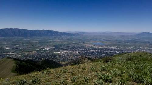
Looking west from Little Baldy.
1. Logan Dry Canyon Trailhead
Follow Center Street in Logan all the way to the end. It will be straight until just after you cross the Logan river and go up a fairly steep hill. At the top of the hill it will curve to the left. Take a right on Mountain Road (Center Street becomes Mountain Road near the end) and follow this to the end.
2. Providence Canyon-Starting from Logan Peak or Welches Flat Road
Looking east up Providence Canyon from where the Syncline Trail meets Welches Flat Road
From the town of Providence go south on 100 East. This will turn into Canyon Road and will start to turn to the east. Eventually it will head up Providence Canyon and it will continue for about 3 miles past the forest boundary to a quarry. From there the road becomes a 4WD trail and leads to the top of the canyon. From there turn north and follow Millville Peak Road (F.R. 168) for 1.3 miles where you will turn west onto Logan Peak Road (F.R. 042). After 2.5 miles you will have reached the top. You can also access Little Baldy via Welches Flat Road (F.R. 152), which splits from Providence Canyon Road (F.R.022) about 1.5 miles east of the old quarry. From that junction to the beginning of the Syncline Trail (029) below Little Baldy is approximately 3.5 miles. Be warned it is highly recommended that you have an ATV or very high clearance for these roads as the conditions are poor, especially near the top of Providence Canyon and on Welches Flat Road.
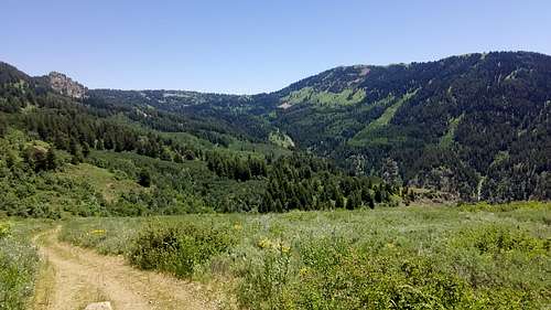
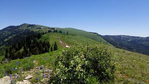
Perhaps the most popular route to Little Baldy for hikers would be ascending via the Logan Dry Canyon (016) and Syncline (029) Trails. Logan Dry Canyon is a steep ascent, but there is a trail the whole way which makes things a little easier. From the trailhead to the junction with the Syncline Trail is 3.6 miles. At the junction, turn south. The Syncline Trail to the base of Little Baldy is about 1.5 miles. From here, follow the ridge east for a about a half mile to the summit. Temple Baldy is also about a half mile west of the Syncline cutoff, so feel free to bag both in one go. If interested in ascending Logan Peak from Little Baldy, follow the ridge a mile east until you hit the tower. You can't miss it.
Distance: Approximately 5.6 miles one way. 3,580' elevation gain.
2. Providence Quarry to Welches Flat Road
For those of us who don't have ATVs or high clearance vehicles, another potential hiking route is up the Providence Canyon Road to Welches Flat Road to the Syncline Trail. From the old quarry follow the road for 1.5 miles until the junction with Welches Flat Road. Follow Welches Flat west until it ends at the southern terminus of the Syncline Trail. From there, follow the trail .5 mile to the base of Little Baldy and ascend east. This route is not the most fun to hike on as the upper reaches of Providence Canyon Road are filled with rocks that are inconvenient to hike on.
Distance: Approximately 6 miles one way. 2,430' elevation gain.
3. Logan Peak Southwest Ridge
Logan Peak from summit of Little Baldy
The easiest way to hit Little Baldy would be to drive to the top of Logan Peak and hike the mile down the southwest ridge to the summit.
Distance: Approximately one mile one way. 930' elevation loss.
Red Tape
Little Baldy is situated in the Cache National Forest and there are no fees to access it at this time. However, SP user Mtybumpo's page on Logan Peak has this to say:"The Road up Providence Canyon is narrow and is a 4WD road. You will need a high clearance vehicle. SP user Dean submitted the following information: John Vitz, one of the most prolific peak baggers in the Western USA, said this,"Logan Peak: I did this as a drive up using the
Millville Canyon jeep road. This is a terrible road.
It took over four hours to do the 22 miles round
trip. It can probably be hiked from Providence
Canyon in about the same amount of time (8 m.r.t;
3000')"
Dry Canyon has NO water in it so you will need to bring your own. There is one spring along the main trail as it heads over the ridge towards Logan Canyon. It is possible to get water there but it is quite far out of your way. This is after you should leave the trail to go to the peak.
Avalanches are common in Dry Canyon as the canyon walls are quite steep. There is also great danger on the North and East sides of the peak.There was a cross country skier killed in dry canyon a few years ago by an avalache and on December 24, 2008 two snowmobilers were killed on the east face of the peak in a massive avalanche.
for current conditions check out the Utah Avalanche Center.
High winds are also quite common on Logan Peak."
When to Climb
Little Baldy can be climbed year round, however, be prepared for avalanche conditions in the winter.Camping
There are no established campgrounds in Dry Canyon or Providence Canyon so the nearest places to camp would be the campgrounds in Logan Canyon. They all lie along the north slopes of Mount Logan. However, there are dispersed camping opportunities in Providence Canyon.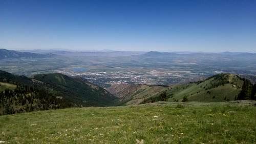
Logan Dry Canyon from near Logan Peak
For info on Providence Peak:
For info on road and trail conditions: