
|
|
Mountain/Rock |
|---|---|
|
|
41.85297°N / 111.68854°W |
|
|
Cache |
|
|
Hiking |
|
|
Spring, Summer, Fall, Winter |
|
|
9676 ft / 2949 m |
|
|
Overview
Mount Elmer is one of the tallest peaks in the southern portion of the Bear River Range of northern Utah's Wasatch Mountains. Though generally hidden behind Flat Top's wide profile when viewed from Cache Valley, Mount Elmer is especially prominent when observed from Logan Canyon and the highlands above Right Hand Fork. Rising to 9,676 feet and nearly 100 feet taller than its nearest neighbor, Mount Jardine, Mount Elmer is the tallest peak on the ridge extending above Birch Canyon to the west, Smithfield Canyon to the north and Cottonwood Canyon to the east. Mount Elmer is located in the Mount Naomi Wilderness and, as such, is one of the crown jewels of the Range. Situated smack dab in the middle of the Wilderness, Elmer is far from any roads. Therefore, only hikers and horseback riders have access to this pristine peak.There are multiple routes one could take to reach Mount Elmer. Perhaps the shortest route is from the Green Canyon trailhead. This route follows the Mount Naomi Peak National Recreation Trail (NRT) and totals 5.3 miles one way. The routes from Smithfield Dry Canyon and the Tony Grove NRT trailhead east of the campground each total about 7.5 miles one way. From Birch Canyon the route is approximately 8 miles one way. Considering the length of each route, this hike can be best done using a shuttle, beginning at Tony Grove and leaving a vehicle at the bottom of Birch Creek, Smithfield Dry, or Green Canyon.
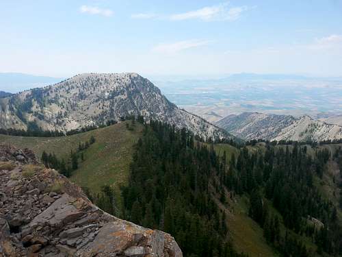
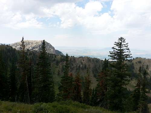
Looking west from the summit toward the backside of Flat Top and Birch Canyon.
Getting There
Considering Mt. Elmer is tucked away in the Mount Naomi Wilderness, a bit of effort must be expended to get here. Furthermore, many of the roads leading to trailheads are closed throughout the winter season.1. Green Canyon Trailhead:
Drive on I-15 north of Brigham City and take exit 362 (US-91/Logan). Keep driving on US-91 through Sardine Canyon. After 25 miles US-91 will merge into Main Street in Logan. Continue driving to the city of North Logan. Turn right at 1900 North and go passed K-Mart. Drive east and the road will turn into 1900 North. Keep driving on this road and there will be a parking lot about 1 mile or so near the mouth of Green Canyon. This is the winter trailhead and any vehicle can be driven here. From this lower winter trailhead it is an extra 3.7 miles of hiking and 1,000 feet of elevation gain. July to November 15, a dirt road continues for 3.75 miles to the upper parking lot. It is in good condition but some cars may find it a little rough.
2. Birch Canyon Trailhead:
Drive on I-15 north of Brigham City and take exit 362 (US-91/Logan). Keep driving on US-91 through Sardine Canyon. After 25 miles US-91 will merge into Main Street in Logan. Continue driving north to the city of Smithfield. Turn east on 100 North Street. Drive two blocks east and then a half block south to Canyon Road. Follow this road east and then northeast for a mile. Turn right onto Birch Canyon Road. There should be a sign marking the way. Follow this windy dirt road for a mile to the mouth of Birch Canyon and a locked gate. This is where the trailhead is located which is about 0.25 mile from the national forest boundary. You will have to park on the side of the road. There is private land and homes near the mouth of the canyon so only stay on the main road.
Birch Canyon looking north from below the saddle
3. Smithfield Dry Canyon Trailhead:
Drive on I-15 north of Brigham City and take exit 362 (US-91/Logan). Keep driving on US-91 through Sardine Canyon. After 25 miles US-91 will merge into Main Street in Logan. Continue driving north to the city of Smithfield. Turn right onto 300 South Street as you enter Smithfield and drive east. The road will turn into dirt and you can drive as far as possible. The owner had previously closed off vehicle traffic because ATV’s and dirt bikes had run all over the slopes of his property. You can walk the final part to the actual trailhead where you will see a gate and sign that says Mount Naomi Wilderness on it. Remember to close all gates that you pass through.
4. Tony Grove Trailhead
Drive on I-15 north of Brigham City and take exit 362 (US-91/Logan). Keep driving on US-91 through Sardine Canyon. After 25 miles US-91 will merge into Main Street in Logan. Turn right onto U.S. 89 at 400 North in Logan. Continue northeast up Logan Canyon for 22 miles and turn left onto Tony Grove Lake Road (Forest Road 003). 6.2 miles up the road turn left onto a small dirt road (F.R. 128). This little loop road serves as the trailhead. If you pass the campground you have gone too far. There is no fee to use this trailhead so be sure to park here rather than at the main Tony Grove Lake parking lot. Tony Grove Lake Road is usually closed from November to June.
1. Green Canyon
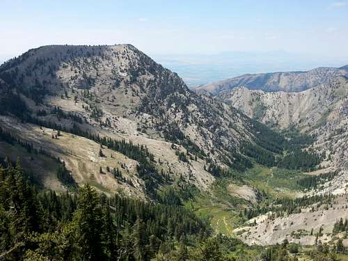
This route is the most direct route to Mount Elmer. The trailhead is at the end of Green Canyon Road (F.R. 050). The entirety of this trail stays on the Mount Naomi Peak NRT. The first four miles climbs up Green Canyon to the ridge between Green Canyon and Wood Camp Hollow in Logan Canyon. This is a pleasant trek with cool mornings, meadows, and the occasional stinking cow carcass. The trail is not too steep. After ascending to the ridge there is a broken sign. Hang left and follow the trail north to Mount Elmer. The trail stays west of the summit so a small Class 3 scramble is required to make it to the top. The easiest ascent is from the southeast side. Mount Jardine is about one mile south of Elmer, which means one could easily back both peaks in one go.
Distance: 5.3 miles one way. 3710' elevation gain.
Mount Elmer from Green Canyon Ridge. Elmer is on the right.
2. Birch Canyon
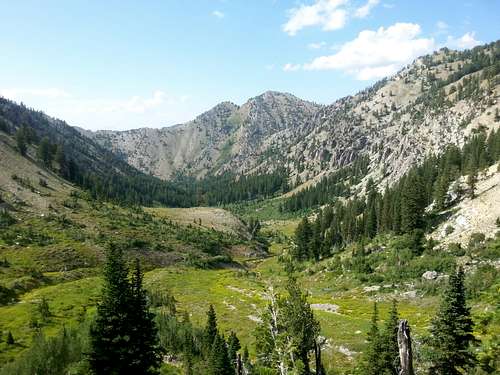
This route is the longest, but Birch Canyon is one of the finest gems in the Bear River Range. The trailhead lies at the end of Birch Canyon Road. The trail follows the old road for about two miles and then becomes single track for 3.6 miles to the saddle behind Flat Top. The stream and surrounding canyon are gorgeous. Moose can be seen in this canyon so be alert near the water. Also, a local rancher grazes longhorns in the lower reaches of the canyon. These guys can be scary! After the saddle follow the faint trail southwest to the Jardine ridge. Bag Jardine if so desired. The 1.8 miles of trail between the saddle and the junction with the Mount Naomi Peak NRT are very faint. Bring a topo map just to be sure you're on the right track. (My favorite is the Logan Bear River Range Nat Geo Trails Illustrated Map.) It is approximately 2.5 miles from the saddle to Mount Elmer. The trail stays west of the summit so a small Class 3 scramble is required to make it to the top. The easiest ascent is from the southeast side.
Distance: Approximately 8 miles one way. 4210' elevation gain.
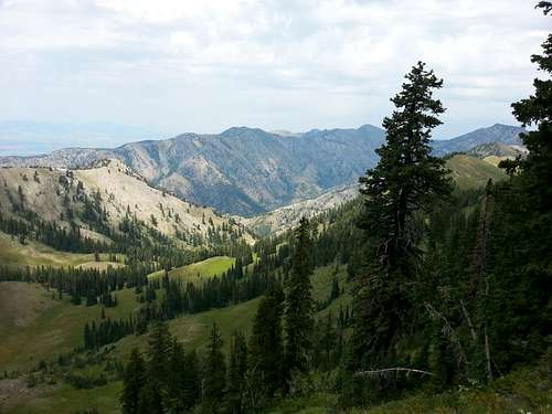
View from the ridge near Mount Jardine of Flat Top and Birch Canyon below
3. Smithfield Dry Canyon
This is the only portion of trail that I haven't been on completely. However, Smithfield Dry is another fairly direct way to Mount Elmer, though longer in length than the Green Canyon route. From what I understand, the upper reaches of Smithfield Dry Canyon are very overgrown. Be prepared for a bushwack. It is 4.5 miles from the trailhead to the saddle junction with the Birch Canyon Trail. After making the saddle, follow the directions above (Birch Canyon) to reach the summit.
Distance: Approximately 7.5 miles one way. 4360' elevation gain.
4. Tony Grove
Another beautiful option, though be prepared to do a lot of ascending and descending before reaching Mount Elmer. Begin this trek at the NRT trailhead east of Tony Grove campground. Parking here is free. As the Green Canyon route, this route follows the Mount Naomi Peak NRT. Proceed up the south switchbacks for the first 1.5 miles. At the first junction (with the Bear Hollow Trail) stay to the right. Proceed west one mile to the ridge above Cottonwood Canyon. Here take the left at the junction. Go south for 1.3 miles until reaching another junction with the Blind Hollow Trail. Go right. This trail will take you down into the dreaded Cottonwood Canyon. In 1.4 miles there will be an unmarked junction with the Cottonwood Trail. This trail no longer exists and only serves to ensnare and destroy the souls of all those who enter (Really, though. My wife mapped invasive weeds down this 3.8 mile canyon and barely made it out after 12 hours of awful bushwhacking). Stay right and begin following the trail back up toward another ridge. This is a very scenic bowl with new growth forest in the higher reaches. Once the trail hits the ridge it is a short jaunt south to Mount Elmer. The trail stays west of the summit so a small Class 3 scramble is required to make it to the top. The easiest ascent is from the southeast side.
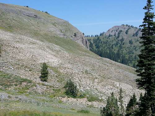
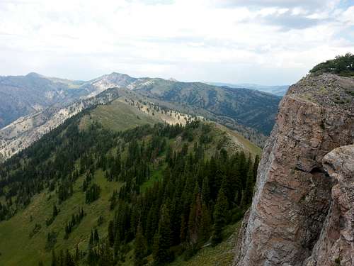
Atop the ridge north of Elmer looking west. Flat Top pokes its head over the ridge east of Birch Canyon
Distance: Approximately 7.5 miles one way. 1725' elevation gain. Keep in mind this doesn't take into account how much elevation you lose dipping into Cottonwood Canyon.
View north on the trail from Tony Grove. Cherry Peak and Naomi Peak in distance.
Mount Elmer is a great destination if backpacking in the Mount Naomi Wilderness. Also, if you have a shuttle vehicle, the trip from Tony Grove down to Smithfield Dry or Birch Canyon is a pleasant, long day hike. Plus you can also bag Mount Jardine and Flat Top on the way down!
Red Tape
Mount Elmer is located in the Mount Naomi Wilderness of Cache National Forest.There are no fees for climbing Mount Elmer.
The only Red Tape for climbing this mountain is negotiating the private property located near the mouth of Birch Canyon and Smithfield Dry Canyon. Access to these areas may be closed at anytime. Most of the problems are due to ATV’s and not hikers. Just use common sense and close all gates, park off the side of the road, and don't disturb anyone else's property when hiking in these canyons.
The Wasatch-Cache National Forest Headquarters is located at 8236 Federal Building, 125 South State Street in Salt Lake City, UT 84138. Phone (801) 236-3400.
Logan Ranger District is at 1500 East Hwy 89 in Logan, UT 84321. Phone (435) 755-3620.
View from Elmer's summit looking north. Naomi prominent with Magog peeking over the ridge.
When to Climb
Max and Elmer
The mountain can be climbed all year since the road to Green Canyon is open to the lower trailhead. It would be a long day to climb Mount Elmer from here in winter. The mountain can also be climbed in late spring and early fall depending on snow conditions. In normal years, snow last in early summer. Many people who have climbed nearby Naomi Peak in early July have encountered a lot of snow at the higher elevations. In fall, there are few people out hiking until October when hunting season takes place.
In winter, the distance from the lower trailhead to the upper trailhead is 3.75 miles. This is packed down pretty good much of the time by snowshoers and skiers. There are several yurts located at different locations in the Bear River Range. One of them is located in Green Canyon. It is assembled and dismantled at the beginning and end of winter unlike the other yurts that stay up year round. Each yurt holds a wood-burning stove, a kitchen and sleeping bunks for as many as 12 different people. Any yurt excursion requires travel by snowshoe or cross-country skis. Renting a yurt costs anywhere from $50-$170 a night, depending on the day of the week and the number of days you are staying. Utah State University students can get a discount off the basic rate. Here is more information on the Green Canyon Yurt.
Camping
Backcountry camping is allowed in all of the canyons located below Mount Elmer. Green Canyon has good places to camp along the way. The lower portions of Birch Canyon and Smithfield Dry Canyon provide nice campsites. Be sure to hike at least a mile above the mouth of these canyons. You must be 200 feet away from any road, trail, or water source. The dispersed camping limit in one spot is 16 days. If you would lake to stay at a campground, there are several located along the Logan Canyon Scenic Byway. Some of them are first come, first serve and others can be reserved online. Campgrounds are usually open from Memorial Day to mid-October. Tent camping is between $18 to $20 a night.Spring Hollow Campground is located 4 miles up the west side Logan Canyon. It is near the Logan River and Spring Hollow Creek. There are 12 sites available. Guinavah Campground is 5 miles up the west side of Logan Canyon. It is located in the forest near the Logan River. There are three loops that have a total of 40 sites. Tony Grove Campground is the most popular place to camp in Logan Canyon. It is about 18 up Logan Canyon at an elevation of 8,100 feet. The campground has 37 sites. Sunrise Campground is located 6 miles west of Bear Lake and 1 mile east of Bear Lake summit. It sits at an elevation of 7,800 feet. There are 27 sites available here. Nearby Logan Canyon Campgrounds: Spring Hollow Campground and Sunrise Campground.
External Links
For info on Mount Jardine:For info on Flat Top:
For Trail and Road Conditions: