
-
 25489 Hits
-
 78.27% Score
-
 9 Votes
|
|
Mountain/Rock |
|---|---|
|
|
34.10060°N / 116.8278°W |
|
|
San Bernardino |
|
|
Hiking, Scrambling |
|
|
Spring, Summer, Fall, Winter |
|
|
9133 ft / 2784 m |
|
|
Overview
Little San Gorgonio Peak is a 9,133' summit located on the challenging and seldom-climbed Yucaipa Ridge. It lies just over four miles southwest of San Gorgonio Mountain, and offers a fantastic view of San Gorgonio, as well as commanding views of the community of Forest Falls and Mill Creek Canyon (home of the Vivian Creek and Momyer trail heads to San Gorgonio). LSG Peak lies just over two miles from Galena Peak and the eastern end of the Yucaipa Ridge.There are four routes that lead to the summit, and none of them are easy. The "simplest" approach is the West-to-East Yucaipa Traverse, which involves fifteen miles, well over 5,000' of gain, and requires special permission from the manager of the Oak Glen Preserveand Bear Paw Preserve. Alternately, you can traverse a much shorter distance along the Yucaipa Ridge east-to-west from Galena to Little San Gorgonio, but summitting Galena itself involves 3,300' of gain in just four miles, an entails a Class 2+ scramble up the imposing Mill Creek Jumpoff. The shortest route involves scrambling up through washes, gullies, and ridges, gaining over 3000' in just two miles. No matter which route you choose, be prepared for a strenuous hike, mild to moderate exposure, and challenging navigation issues.
Getting There
Take interstate 10 to the city of Redlands, and exit at the sign for CA38 (just past the exit for CA30). Turn left (north) on Orange St, crossing under interstate 10. After traveling five blocks on Orange St., turn right (east) on CA38. Follow CA38 14mi to an intersection with Valley of the Falls Dr. Bearing right, follow Valley of the Falls Dr. for 3mi to the Vivian Creek Trailhead.Route Descriptions
There are two routes described below. Both require good navigation skills. In addition, the Camp Creek route follows a rocky and loose drainage, some of which is steeper than the angle of repose. In addition, I recommend following Camp Creek only during the dry season, as wet rock makes the route more dangerous.Camp Creek
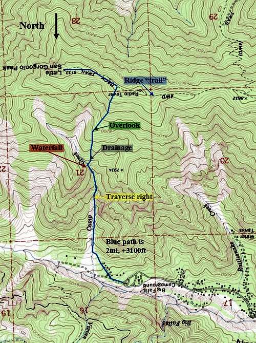
The route from Camp Creek begins at the Vivian Creek trailhead above the town of Forest Falls. Although it is only 2mi to the crest of Yucaipa Ridge, the vertical rise is 3000ft. Doing the math, that's an average grade of 18%. Although technical climbing is avoidable, you should be comfortable with difficult class 2 travel.
Begin at the Vivian Creek trailhead. Follow a dirt road through an area of cabins. Another dirt road branches to the South, passing by several more cabins. Take this road to its end and then ascend a small drainage. After a few hundred feet, the bed of Camp Creek becomes visible to the hiker's left. Descend into Camp Creek and head uphill.
The first 0.5mi in the streambed is easy and dry. Although several tributaries descend into Camp Creek, its main bed remains the most obvious and easiest route. After approximately 0.5mi, the canyon narrows, steepens, and the first waterfall is encountered. Depending on the flow, it may be possible to ascend the 15ft chimney (class 3-4) to its left. However, it is also possible to climb its western slope and traverse above the main drop.
The climbing becomes easy above the first waterfall until a second waterfall is encountered approximately 1mi from Vivian. Ascending the second falls is possible but is at least class 3 climbing; the rock is also loose! Instead of climbing the falls, I left Camp Creek and ascended small drainage to the SW. The drainage climbs 600ft to a ridge overlooking the Camp Creek canyon. Little San Gorgonio Peak is now visible across the canyon to the SE. Continue another 0.4mi and 800 vertical feet to the crest of Yucaipa Ridge. A radio tower is visible to the west and Little San Gorgonio Peak is 0.4mi and 100 vertical feet to the east. The "pack trail" is little used and fades out frequently.
The trickiest part of the decent is finding the drainage that leads to the second waterfall. When in doubt, hike along the rim of Camp Creek's canyon and head directly north toward San Bernardino Peak (across Mill Creek). The rocky streambed of Camp Creek, visible far below, is also obvious.
 |  |  |  |
Yucaipa Ridge
The Yucaipa Ridge "pack trail" is little used and not obvious. According to the Sierra Club's description this route is 13mi (one way) with 4100 feet of gain. Instead of heading to the Vivian Creek trailhead, park at the turnoff for Valley of the Falls Dr. and hike across Mill Creek on forest service road S108. This trail crosses private property, and you need the appropriate permissions. See the link for more detail.
Red Tape
An adventure pass is required to park in the San Bernardino National Forest.This route is NOT in the San Gorgonio Wilderness, so a wilderness permit is NOT required!
Special Equipment and Precautions
Your partners will knock rocks loose, so a helmet is advisable. There is also a plant resembling Stinging Nettle prevalent throughout the streambed. Touching its thorns feels like sticking a needle in your skin and may give a mild allergic reaction. Long pants are needed. Gloves and a long shirt are optional but may be helpful. Bring a topo map and compass.In comparison with the routes across the valley to San Gorgonio, the Yucaipa Ridge is seldom traveled. Climb with a partner and/or leave detailed plans. Beware of thunderstorms - they will turn this creek into a torrent.
External Links
San Bernardino National ForestHPS Climbing Archives