
-
 6187 Hits
-
 90.81% Score
-
 33 Votes
|
|
Mountain/Rock |
|---|---|
|
|
28.20127°N / 16.635°W |
|
|
Hiking |
|
|
Spring, Summer, Fall, Winter |
|
|
8176 ft / 2492 m |
|
|
Overview
 Guajara and Lomo de Las Mesas as seen through a Gap near Roque de los Almendros Guajara and Lomo de Las Mesas as seen through a Gap near Roque de los Almendros |
All of the highest mountains of the island of Tenerife are located in or around the giant crater of the Cañadas del Teide. While Teide, Pico Viejo and Montaña Blanca are located in the centre, all other mountains form the walls on the caldera rim. The crater - or what is left over from it reaches from La Fortaleza in the north-east, surrounds the Cañadas on their southern side and ends with the Roques del Cedro in the west. The highest and most impressive of these caldera mountains, Topo de la Grieta, La Guajara and El Sombrero are located in the southern part of the giant circle.
Right there, in fact right between La Guajara and El Sombrero you can find a long stretched ridge, Lomo de las Mesas, which conects the two mountains. Thanks to its impressive north face, which drops for several hundred metres towards Llano de Ucanca and thanks to two saddles, which separate it from the rest of the caldera summits, it can be considered a mountain apart. The name Lomo de las Mesas already indicates the character of the mountain, a ridge, which forms a table-like plateau and when you look at the summit from the outside of the caldera you will barely distinguish it from the rest.
 |  |  |
Still - Lomo de las Mesas is not exactly easy to climb. The outside approach is barred by thickets of gorse bushes on difficult lava terrain, so that the usual approach follows the ridge of the caldera rim. As said above, there are two saddles on both sides of the summit ridge and from both passes rather challenging scrambling routes lead to the plateau. While the eastern approach from Degollada de Ucanca climbs through rocky terrain on the caldera outside the western approach directly leads across the ridge, in several places very exposed above the Lomo de las Mesas north face.
 |  |  |
This face itself is made from loose lava scree so that a direct climb from Llano de Ucanca, the flat sedimentary plain underneath is firmly out of the question. The summit of Lomo de las Mesas on the other hand is formed by basaltic rocks, often spherical lava bombs, which found their way across the Cañadas during one of the eruptions of Pico Teide. Needless to say that the gallery location opposite of Teide makes Lomo de las Mesas a perfect lookout summit, especially since it is climbed much less often than neighbouring Guajara with its similar view.
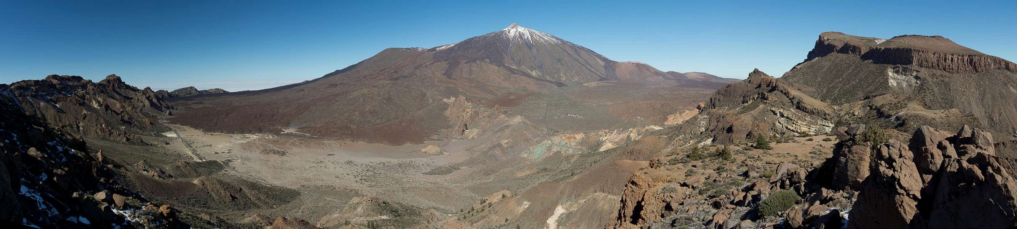
A Panorama from the top
  |
Routes
 Looking across Lomo de Las Mesas towards La Guajara
There are two reasonable routes to get to the top of Lomo de las Mesas, one starting at highway TF21 north of Villaflor, one at the Parador Hotel. Maps also show a trail starting from Boca de Tauce but this is hard to find and looks dangerous crossing the brittle north faces of the Caldera Rim.
 Rocky passage on the west ridge of Lomo de las Mesas
From TF21 you take a marked hiking trail, wich takes you through or above Barranco de la Maglalena to the base of Sombrero de Chasna and from there on to the caldera rim west of Lomo de las Mesas. Follow the path that follows the boundary of the National park.
 Lomo de las Mesas seen from Degollada de Ucanca
From the Parador Hotel head for Degollada de Ucanca, the saddle separating Guajara from Lomo de las Mesas. It is a steep an brittle path until you reach the saddle. Turn right (west) and follow the ridge towards the summit.
Getting There
 Looking towards a gap at the base of Roque de los Almendros towards Teide
There are two trailheads for the climb of Lomo de las Mesas. One is the Cañadas Highway near the Parador Hotel, the other the highway between Vilafor and Boca Tauce. The cimbing routes share quite a lot of their ways with either the Guajara western ascent along Degollada de Ucanca and the ascent of Sombrero de Chasna through Barranco de la Magdalena.
- Parador Hotel
The hotel is located in the midsts of the Cañadas del Teide, which can be reached from four sides:- TF21 from Granadilla de Abona through Vilaflor (S)
- TF38 from Guìa de Isora (W)
- TF21 from La Orotava (N)
- TF24 (Cumbre Highway) from La Esperanza (E)
The best parking can be found at the Roques de Garcia, though you should take care to leave no valuables in your car there.
- TF21 from Granadilla de Abona through Vilaflor (S)
- Western Trailhead at TF21
Take TF21 from Granadilla de Abona through Vilaflor. The trailhead is near km 59.5 close to an abandoned shed on the right hand side.
Alternatively you can take a bus either from Playa de las Americas (Line 342) or from Puerto de la Cruz (Line 348). Both buses depart at about 9:00 a.m., the return buses go around 4:00 p.m.
Red Tape
 El Teide with basalt sphere on Lomo de las Mesas
Lomo de las Mesas is located on the border between the Parque Nacional del Teide which is composed of a giant volcanic crater the Cañadas del Teide with 48km circumference, and the Parque Natural Corrona Forestal, a natural park in which similar rules apply as in the national park. Trails are marked and it is not permitted to leave them. Plants may not be removed and the few animals have to be left alone. Some places in the Corrona Forestal Park are private hunting grounds but not in this part close to the Cañadas.
Accommodation
Of course you can find a lot of hotels, fincas and casas on the island which you can book from any travel office. The Cañadas del Teide are a natural park so camping is not allowed. You might use the Parador Hotel which is supposed to be quite expensive, however. Better stay at one of the hotels at sea level and drive up by rental car or bus.The closest town is Vilaflor, which though it certainly offers inns and hotels, certainly is not one of the most popular tourist destinations.
Weather Conditions
There are several sites on the web which give you information on the weather on Tenerife. However, they all show the weather for the coastal regions which significantly differs from the weather in the Cañadas del Teide which are 2000m of elevation higher. The following table shows data for Puerto de la Cruz on the north coast.| Month | Jan | Feb | Mar | Apr | May | Jun | Jul | Aug | Sep | Oct | Nov | Dec |
| Avg. day temp.[°C / °F] | 19 / 66 | 19 / 66 | 20 / 68 | 21 / 70 | 22 / 72 | 23 / 73 | 24 / 75 | 26 / 79 | 26 / 79 | 24 / 75 | 22 / 72 | 20 / 68 |
| Avg. night temp.[°C / °F] | 13 / 55 | 13 / 55 | 14 / 57 | 14 / 57 | 16 / 61 | 18 / 64 | 19 / 66 | 20 / 68 | 20 / 68 | 18 / 64 | 17 / 63 | 14 / 57 |
| Water temp.[°C / °F] | 19 / 66 | 19 / 66 | 19 / 66 | 19 / 66 | 20 / 68 | 20 / 68 | 22 / 72 | 23 / 73 | 22 / 72 | 22 / 72 | 21 / 70 | 20 / 68 |
| Rainy days | 10 | 7 | 8 | 4 | 3 | 2 | 1 | 1 | 3 | 5 | 7 | 9 |
The Canary Islands (as well as Madeira) are located in the trade wind zone. You almost always encounter northeastern winds which carry a lot of humid air. Being forced to climb to higher altitudes this moisture condenses into clouds. This in return means that most of the time the northeastern part of the islands is covered in clouds from altitudes of 1000m through 2000m.
The mountains themselves - being mostly of the same altitude - finally stop the clouds so that on their southeastern slopes the clouds "run out". In the case of Tenerife the Cañadas del Teide are so high that rarely ever you encounter fog or clouds. This on the other hand means that the whole area is very dry so be sure to bring your own water.
Maps & Books
Out of the multitude of maps and books I have been using the following. However, so far I have not found a good hiking map of the island. The one posted here is ok but shows only a fraction of the marked hiking trails. The guidebook is excellent but be careful if you do any one of the suggested "variations" to the tours described therein. The variations are described in a few words only and you might get the wrong impression of their quality.- Maps
- Teneriffa
Kompass Map WK233
Kompass Verlag
ISBN: 3-85491-038-X
Books
- Teneriffa, Tenerife
K.Wolfsperger, C. Ade
Rother Walking Guide
Rother Verlag
English - ISBN: 3-7633-4809-3
German - ISBN: 3-7633-4016-5