
-
 3587 Hits
-
 81.18% Score
-
 13 Votes
|
|
Mountain/Rock |
|---|---|
|
|
28.22042°N / 16.59314°W |
|
|
Hiking |
|
|
Spring, Summer, Fall, Winter |
|
|
8297 ft / 2529 m |
|
|
Overview
 Montaña Pasajiron seen from Cañada de la Grieta Montaña Pasajiron seen from Cañada de la Grieta |
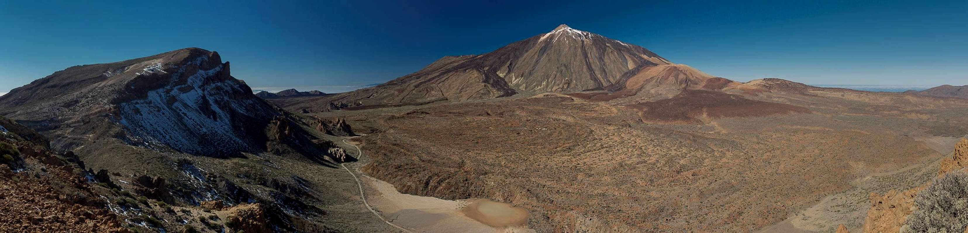
The Cañadas del Teide on Tenerife are among the most spectacular mountain sceneries on this planet. The giant crater which boasts a circumference of 48km was created when part of the stratovolcano (a proto-Teide) which rose in its midst, collapsed and much of its material slid northward through what is now Orotava Valley, creating a huge shelf on the ocean floor. Today the Cañadas form a giant crater basin with Pico del Teide in the north-west and a half circle of rim mountains to the south-east.
Montaña Pasajiron is located almost in the centre of this half circle between Guajara and Roque de la Grieta, numbers one and three on the elevattion list of rim mountains. At 2529m Montaña Pasajiron comes in at number six only three metres lower than El Sombrero and two metres lower than Roque de los Almendros. Montaña Pasajiron is round-topped with a massive north face, which towers above Cañada de la Grieta. To its south it shows smooth slopes like all of the rim mountains, which gradually turn into the Corona Forestal pine forest.
 |  |  |
The ground on the summit plateau is very soft, as you cross it you will leave deep traces. Don't step too close to the north face as the ground (made up from old volcanic cinder) will start to shift and slide northwards. View rival any of the rim mountains though ofthe neighbouring islands only Gran Canaria can be seen to the south-east, while El Hierro and La Gomera are hidden behind Guajara while La Palma is only partly visible behind Pico Viejo.
 |  |  |
Montaña Pasajiron usually is not a destination in its own right. Most people hike to neighbouring Guajara instead. Therefore you will have the summit to youself for most of the time. However, the Cañadas High Route, which connects El Portillo with the Parador Hotel runs right across the mountain's summit so that anyone who attempts the 15km route will pass by. The high route can be combined with a route through the Siete Cañadas beneath the north faces of the rim mountains, a serious 30km loop, which takes a minimum of 9h.
Summit View
  |
Getting There
 Montaña Pasajiron seen from the south-west
There are three trailheads for reaching Montaña Pasajiron. One is the Cañadas Highway near the Parador Hotel, the other is near the National Park Headquarters at El Portillo and the third, somewhat remote trailhead is in the vicinity of Villaflor to the south of the Cañadas. All are connected by the Cañadas Highway (TF21)
There are four access roads to the Cañadas del Teide
- TF38 from Guìa de Isora (W)
- TF21 from La Orotava (N)
- TF24 (Cumbre Highway) from La Esperanza (E)
- TF21 from Granadilla (S). The trailhead is on a dirt road which starts from TF21 four switchbacks above Villaflor.
The trailheads in the Cañadas come with parking lots. However, the ones near Parador Hotel and Roques de Garcia is notoriously overcrowded.
Routes
Route from Parador Hotel Teide seen from Cañada de la Grieta during the ascent of Montaña Pasajiron
From the dead end rouandabout south of the hotel a hiking path leads southward in direction of Guajara. It joins a dirt road running through the Siete Cañadas beneath the north faces of the rim mountains. This road avoids the rock cities near Piedras Amardillas. After having circled the Guajara north face it heads to a spot beneath Degollada de Guajara, which separates this mountain from Montaña Pasajiron. A brittle, narrow path leads up to the saddle. Turn left onto a steep path which heads directly to the summit plateau of Montaña Pasajiron.
Route from El Portillo
 Montaña Pasajiron seen from the south slopes of Roque de la Grieta
From the visitor centre cross the highway to hike down a dirt road, which heads down into the Cañadas. It splits after a few hundred metres and you need to take the left hand branch (trail No 2). Running eastward it hits an intersection, where you need to switch to trail No 8, which gradually heads for the caldera rim. In general you follow this path, which turns into a dirt road once you're on top of the rim and runs along its outside.
After having passed Montaña de la Angostura the road turns very rugged as it passes Topo de la Grieta and Roque de la Grieta on the outside (south). South of Roque de la Grieta the road ends altogether and turns into a path. which heads towards a saddle east of Montaña Pasajiron. From here a well marked path leads to the summit plateau along the east ridge. Take care in snow and ice conditions. The ridge will remai covered in snow far longer than the rest of the mountain. Some of the sections of the east ridge are steep and exposed.
Route from Villaflor
 Montaña Pasajiron seen from Degollada de Guajara
You can start in Villaflor but since the village is located at roughly 1100m only, the elevation difference would be extreme. Therefore the best trailhead is on a dirt road which turns off from TF21 four switchbacks above Villaflor. The trailhead is close to the trailhead to Paisaje Lunar and in fact the nicest route runs by the moonscape.
Follow the path which leads to Paisaje Lunar but stay in the valley until you reach an intersection, where a steep path takes you westward away from the hoodo towers. The path runs into a broad path on which you have to turn right (east). After you crossed the timberline your trail runs out a broad valley where you can see Paisaje Lunar Negro, another set of hoodoos carved out of black lava.
You head out of the valley on the eastern side where a the path turns north running directly for Degollada de Guajara. After a cinder section the terrain gets rocky but the path negotiates all obstacles smoothly. A route to Guajara turns off to the left, the path takes a wide turn to the right and finally ends in the saddle. Turn right here and a steep path will take you to the summit plateau of Montaña Pasajiron
Red Tape
Montaña Pasajiron is located on the border between the Parque Nacional del Teide which is composed of a giant volcanic crater the Cañadas del Teide with 48km circumference, and the Parque Natural Corrona Forestal, a natural park in which similar rules apply as in the national park. Trails are marked and it is not permitted to leave them. Plants may not be removed and the few animals have to be left alone. Some places in the Corrona Forestal Park are private hunting grounds but not in this part close to the Cañadas.Accommodation
Of course you can find a lot of hotels, fincas and casas on the island which you can book from any travel office. The Cañadas del Teide have been declared national park so camping is not allowed. You might use the Parador Hotel which is supposed to be quite expensive, however. Better stay at one of the hotels at sea level and drive up by rental car or bus.The closest villages are Vilaflor and Aguamansa to the south and north of the Cañadas, respectively. Both offer inns and hotels but are not among the most popular tourist destinations.
Weather Conditions
There are several sites on the web which give you information on the weather on Tenerife. However, they all show the weather for the coastal regions (Puerto de la Cruz, Los Cristianos, La Orotava) which significantly differs from the weather in the Cañadas del Teide which are 2000m higher. The following table shows data for Puerto de la Cruz on the coast.
| Month | Jan | Feb | Mar | Apr | May | Jun | Jul | Aug | Sep | Oct | Nov | Dec |
| Avg. day temp.[°C / °F] | 19 / 66 | 19 / 66 | 20 / 68 | 21 / 70 | 22 / 72 | 23 / 73 | 24 / 75 | 26 / 79 | 26 / 79 | 24 / 75 | 22 / 72 | 20 / 68 |
| Avg. night temp.[°C / °F] | 13 / 55 | 13 / 55 | 14 / 57 | 14 / 57 | 16 / 61 | 18 / 64 | 19 / 66 | 20 / 68 | 20 / 68 | 18 / 64 | 17 / 63 | 14 / 57 |
| Water temp.[°C / °F] | 19 / 66 | 19 / 66 | 19 / 66 | 19 / 66 | 20 / 68 | 20 / 68 | 22 / 72 | 23 / 73 | 22 / 72 | 22 / 72 | 21 / 70 | 20 / 68 |
| Rainy days | 10 | 7 | 8 | 4 | 3 | 2 | 1 | 1 | 3 | 5 | 7 | 9 |
The Canary Islands are located in the trade wind zone. You almost always encounter northeastern winds which carry a lot of humid air. Being forced to climb to higher altitudes this moisture condenses into clouds. This in return means that most of the time the northeastern part of the islands is covered in clouds from altitudes of 1000m through 2000m.
The mountains themselves - being mostly of the same altitude - finally stop the clouds so that on their southeastern slopes the clouds "run out". In the case of Tenerife the Cañadas del Teide are so high that rarely ever you encounter fog or clouds. This on the other hand means that the whole area is very dry so be sure to bring your own water.
Maps & Books
Out of the multitude of maps and books I have been using the following. However, so far I have not found a good hiking map of the island. The one posted here is ok but shows only a fraction of the marked hiking trails. The guidebook is excellent but be careful if you do any one of the suggested "variations" to the tours described therein. The variations are described in a few words only and you might get the wrong impression of their quality.- Maps
- Teneriffa
Kompass Map WK233
Kompass Verlag
ISBN: 3-85491-038-X
- Teneriffa
Freytag & Berndt
ISBN: 978-3-7079-1061-2
- Teneriffa
- Books
- Teneriffa, Tenerife
K. & A. Wolfsperger
Rother Walking Guide
Rother Verlag
English - ISBN: 978-3-7633-4809-1
German - ISBN: 978-3-7633-4016-3
French - ISBN: 978-3-7633-4904-3
Spanish - ISBN: 978-3-7633-4700-1
- Teneriffa, Tenerife