
-
 31443 Hits
-
 86.78% Score
-
 23 Votes
|
|
Area/Range |
|---|---|
|
|
32.75032°N / 16.98486°W |
|
|
6106 ft / 1861 m |
|
|
Overview
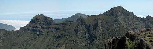
 Pico Grande from the south Pico Grande from the south |
Madeira - does the name ring a bell? Most people - when they hear the name - can't help thinking of the wine of the name though it is not the easiest wine to come by. Certainly not if you want to get a hold of the high quality real stuff. To get it over with right from the start - Madeira wine is made of four different kind of grapes resulting in four distinctively different types of wine, Sercial(dry), Verdelho, Boal Malvasia (Malmsey, very sweet). Like with Sherry the fermentation is stopped by adding brandy after which it will be heated and stored for several years in oaken casks. Unlike Sherry the different wines are never blended, they are drawn onto bottles and can be stored up to 100 years if the bottels are re-corked every 15 years. 5 million bottles are produced each year and the best wines of any year can reach prices of upwards of 200$. The alcohol proof is 18 - 21%.
Now what would you guess the place is called, where this famous wine is grown? Yes, some of you guessed right - it's Madeira. It is an island in the Atlantic ocean located about 1000km north-west of the Islas Canarias and sharing much of their history. The base of the island was formed when the South American and African continents drifted apart, and it drifted far more westwards than the bases of the Canarias did. But still Madeira is of volcanic origin having been created 20 million years ago like the eastern Canarian Islands Lanzarote and Fuerteventura. The latest eruption, however, was 400000 years ago which left Madeira with completely different appearance. In addition to the main island there are several smaller ones: Porto Santo, the Ilhas Desertas and the Ilhas Selvagens, the latter two being groups of very small islands.
  |
With not quite 800 square kilometers Madeira is a rather small island but it makes up for it with its appearance. I like to think of Madeira as the "vertical island" as there are only few places that don't have an impressive vertical wall just beside them. The island is almost 2000m high with its highest summit, Pico Ruivo, at 1861m. Though it might not been aparent from the map Madeira is divided in two parts by two deep valleys the Ribeira Brava and Ribeira de Sao Cicente Valleys which both climb up steeply to the Encumeada Pass. This pass is in more than one respect a prominent spot as it is the lowest point of Madeira's deeply pronounced weather divide and rarely can be seen without a cap of clouds cascading from the north to the Ribeira Brava Valley in the south. To the east of Bocca de Encumeada you will find Madeira's central massif with it's highest summits, to the west a fern covered high plateau called Paúl da Serra.
As a vertical island Madeira doesn't sport any beaches. There are some very small ones but they are so scarce that they can be (and are!) ignored. 95% of the island's coast is vertical (you might have guessed that one too) and only in a few spots some rock basins have been secured far enough to offer convenient pools for swimming.
So what is it that one does on Madeira? The answer is - hiking. This is the island with most certainly the largest network of hiking trails you can find anywhere in the world. The reason has to do with the completely different wether on the northern and southern sides of the island. While the north is very wet (you rarely find a spot in which you don't hear constant dripping or gurgling) the south is considerably dryer. Yet thanks to the larger amount of sunny hours the south is were the orchards and vinyards are so that precious H20 has to be brought somehow to the other side. Madeirans created a vast network of irigation channels, the Levadas, which form a network of a nength of 1400km (!!!), which circumvents mountains or goes through them by tunnels. All levadas come with a track beside them meant for channel maintenance but as often used as a hiking trail. Thanks to the many tunnes you need to bring flashlights with you otherwise your head's in real danger of being split by the sharp edged volcanic rock.
Though the levadas are level and might sound like lame and unexiting they were often built directly into the sheer vertical faces. And the railings which sometimes "protect" the more exposed patches are always thin and shaky. You need lots of experience to hike the more difficult Levadas.
An Overview of Madeira's mountains
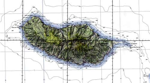 Overview map of Madeira Island
As said above Madeira can be split in two halves and both come with their mountainous regions. While the eastern half of Madeira hosts its highest mountains around 1800m, the western part is home to the high plateau Paúl da Serra at roughly 1600m. There are only few mountains on the high plateau, however. The mountains are listed from east to west - four of them are already posted on SP.
Central Massif
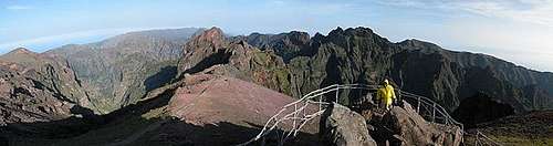 Fisheyed summit view from Pico Arieiro
Madeira's highest summits are located very close to each other right in the centre of the island. There are two access roads which reach quite near to either Pico Ruivo or Pico Arieiro. Both mountains are connected by a beautifully secured, mightily exposed trail.
- Pico Pico das Pedras (1302m)
- Chiceiros da Queimada (1407m)
- Cabeço da Lenha (1476m)
- Pico do Arieiro (1818m)
![]()
- Pico do Cidrão (1801m)
![]()
- Pico do Gato (1780m)
![]()
- Pico das Torres (1847m)
![]()
- Torre de Cerro
![]()
- Pico Ruivo (1862m)
![]()


Weather Divide
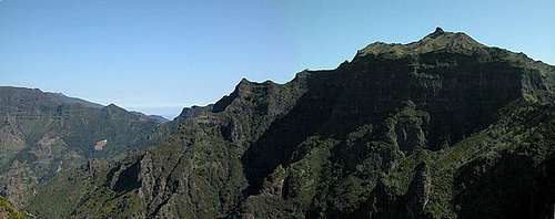
 Pico da Cabra (1588m), Pico Casado (1725m) seen from Pico Grande
The ridge between Pico Ruivo and Bocca da Encumeada is Madeira's main weather divide. A number of beautifully grown over can be climbed using the ridge trail.
- Pico Laie (1582m)
![]()
- Pico das Eirinhas (1649m)
![]()
- Pico Casado (1725m)
![]()
- Pico do Jorge (1691m)
![]()
- Pico Ferreiro (1584m)
![]()
- Pico da Cabra (1580m)
- Pico da Escada (1418m)
- Pico da Selada (1418m)
- Pico da Encumeada
![]()
- Pico Topeiro
![]()


Pico Grande Ridge
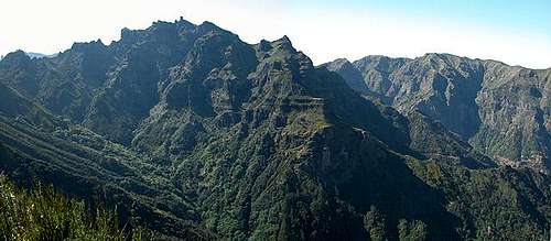 The Pico Grande Ridge seen from Bocca da Encumeada
From the weather divide a ridge diverts south culminating in Pico Grande, Madeira's prime Lookout peak. Getting to its summit requires some UIAA I scrambling.
- Pico das Empenas (1455m)
- Pico do Cerco (1620m)
![]()
- Pico Grande (1654m)
![]()
- Pico da Serradinho (1443m)
![]()
- Chao dos Terreiros (1436m)
![]()
- Pico da Malhada (1236m)


Paúl da Serra Summits
Out of the high plateau Paúl da Serro only occasional mountains and hills pop up. There is no pronounced order among them. Often they can be barely made out as mountains.
Pico Bica da Cana
- (1620m)
 |
- (1640m)
 |
Pico da Selada
- (1446m)
Pico da Fajã da Lenha
- (1370m)
Pico Queimado
- (1339m)
Other Sights
Yes, there's more to Madeira than just wine and mountains. I will spare you the mention of Funchal's and Santo Antonio da Serra's botanical and estate gardens though they definitely are worth a visit. I want to concentrate on climbing and hiking related spots
The Levadas
As mentioned above there are 1400km worth of irrigation channels on Madeira, directing water from the humid north to the arid south of the islands. All levadas come with maintenance trails which can be used as convenient hiking paths. However the levadas often cross right across high walls, or through tunnels of all lengths. Some of them can be very exposed and really exiting. Consider yourself in a mile long tunnel without any light other than the small flashlight you carry. You have to take care of the bumps overhead and the rocks on the trail. Or thing of balancing along a foot wide wall above 500 feet drops.
 |
 |
The Caldeirãos
To the sides of the mountain areas of Madeira you can find collapsed volcanic craters. They form huge vertical (and that's really vertical!) circular walls of huge dimensions on one side while the second half is open - crumbled away into the depth of the valleys below. Reaching these cauldrons is almost as exciting as standing in their midst and gazing up in awe. Mostly they are reached by levadas - but remote ones which go along miles and miles of pristine landscapes often above vertical drops not unlike the ones of the Caldeirãos. One specific Caldeirão, Caldeirão do Infernio can only be reached by climbing through a narrow lightless gorge and three tunnels. In the end you stand in the focal point of the monster with the sun focussed right around you - literrally unbearable - hot and headsplittingly bright!
 |
 |
Cabo Girão
On the southern coast of Madeira just west of the capital Funchal you can find Cabo Girão, reportedly the second highest sea cliff in the world. A road goes right on top, a lift goes down to the sea where there is a vineyard for the famous Madeira wine directly on the sea.
 |
Ponta de São Lourenço
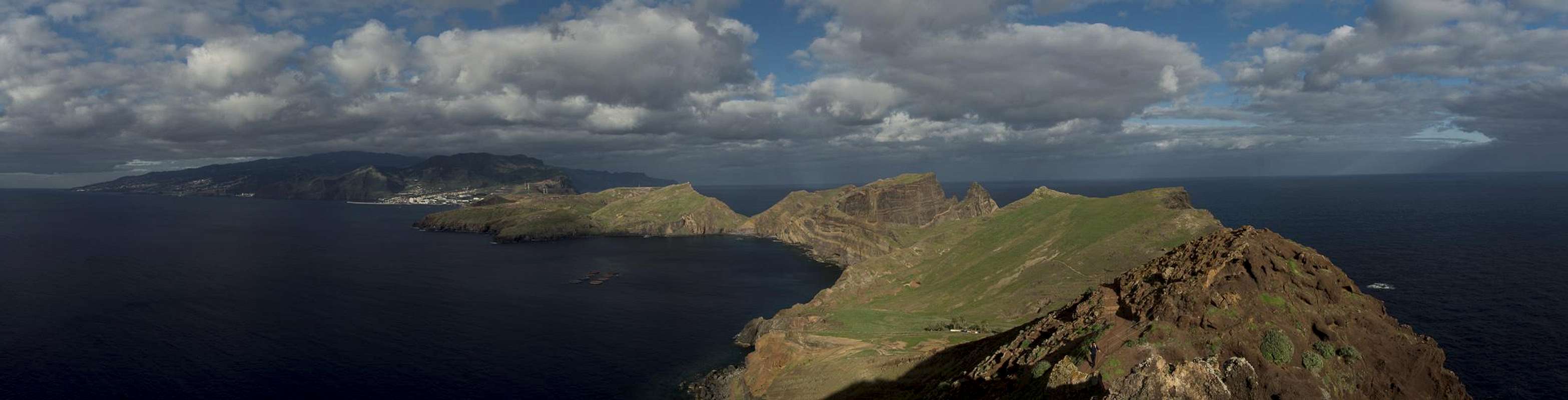
The eastern tip of Madeira, Ponta de São Lorenço is a peninsula which is connected with the main island by a ridge, which is only several meters wide. The sea has been eating away the coast and is only a matter of time when the peninsula will be an island itself. Good hikes and scary views into the sea. The highest point is Pico Furado at the easternmost end of the island.
Paúl da Serra
The high plateau of Paúl da Serra is covered in hip high ferns. Navigating the plain can be very difficult, especially in the (frequent) times of fog. Better grab yourself a levada and follow that.
 |
The Taginaste
Finally - and this is the main attraction for me - I come to the beautiful blue Madeira Taginaste. The species can be found anywhere on earth but never so beautiful as here. In itself the flowers are worth a visit to the island.
 |
 |
Getting There and Accommodation
As said somewhere above you can reach Madeira from almost any major European airport on a twice weekly basis. From Lisbon and Porto there are daily flights. For the flight schedules look at the websites of the large charter airlines (e.g. Thomas Cook or Hapag Lloyd). But anyway - landing at Funchal airport is one of the scariest experiences you can imagine. The air is always very turbulent and you come in hovering above the steep coast towards one of the shortest runways on which full grown jets can land. It is built on pillars and at its end looms a solid rock!
Back to the topic – you can rent hotel rooms and apartments from any travel office in Europe (overseas might be a bit more difficult). Many of the large companies have their own web sites so that you might look them up there as well (for example again the above mentioned companies).
Local transport is available by taxi. There are bus lines but the remoter areas are rarely visited. It pays to get a rental car, especially on the larger of the islands. Obtaining a car is easy, prices are quite high though (European standard). Be sure to get a car with some ponies under its hood - the roads are often extremely steep and you have to revert to first gear frequently. There is a motorwayaround and through the capital Funchal. However most of the island is only accessible by small mountain roads and the northern coastal route is notorious for its narrow tunnels and its waterfalls coming down stright on your car roof. Convertibles are no good idea there.
Red Tape
There is no red tape to speak of. Madeirans are not the environmentally most concious people - you often fond debris rotting beneath the dense vegetation. However the levadas are different. They are the heart and bone of Madeira's agriculture and they are very well kept. Often the water is so clean that you find trout swimming in the channels. Though there are cleaning basisns at regular intervals you should definitely try and keep the water clean.
Weather Conditions
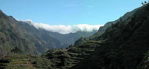 Trade wind clouds ooze over Boca da Encumeada
As for the Canarias weather conditions cannot be predicted accurately. Madeira is located in the trade wind zone. You almost always encounter northeastern winds which carry a lot of humid air. Being forced to climb to higher altitudes this moisture condenses into clouds. This in return means that most of the time the northern part of the island is covered in clouds from altitudes of 1000m through 2000m.
The mountains themselves - being of the same altitude -finally stop the clouds so that on their southeastern slopes the clouds "run out". Look at the pictures - it looks like the clouds creeping over the weather divide. Boca da Encumeada - being some 500m lower than the surrounding summits - is a gateway for the clouds from north to south. Thus it very often is covered in mist.
Unfortunately all of the major peaks of Madeira lie around the weather divide. Sometimes within, sometimes just out of the clouds. Pico Grande is a little safer since it is located a little to the south of the divide and most of the time the clouds don't reach the summit.
You can get the actual forecast at Weather online
The following table shows weather data for Funchal on the southern coast. Be careful with these data if you want to climb the summits...
| Month | Jan | Feb | Mar | Apr | May | Jun | Jul | Aug | Sep | Oct | Nov | Dec |
| Avg. day temp.[°C / °F] | 16 / 61 | 16 / 61 | 17 / 63 | 20 / 68 | 24 / 75 | 27 / 81 | 29 / 84 | 29 / 84 | 27 / 81 | 23 / 73 | 21 / 70 | 17 / 63 |
| Avg. night temp.[°C / °F] | 9 / 48 | 9 / 48 | 10 / 50 | 12 / 54 | 15 / 59 | 19 / 66 | 21 / 70 | 22 / 72 | 19 / 66 | 16 / 61 | 13 / 55 | 11 / 52 |
| Water temp.[°C / °F] | 16 / 61 | 15 / 59 | 16 / 61 | 16 / 61 | 19 / 66 | 22 / 72 | 24 / 75 | 25 / 77 | 24 / 75 | 23 / 73 | 20 / 68 | 17 / 63 |
| Rainy days | 12 | 7 | 8 | 4 | 2 | 1 | 0 | 0 | 2 | 6 | 6 | 10 |
 |
 |
 |
 |
 |
Maps & Books
Maps
- Madeira and Porto Santo
Euro Tour
1:75 000
ISBN: 972-9328-29-3
(recommended by Corax) - Madeira
Freytag und Berndt
1:50000
ISBN: 3707904660
Books
There are many books about Madeira the following is excellent and available in German and English:
- Madeira
Rolf Goetz
Rother Verlag
ISBN: 3-7633-4274-5 (German)
ISBN: 3-7633-4811-5 (English)