
-
 10165 Hits
-
 79.04% Score
-
 10 Votes
|
|
Mountain/Rock |
|---|---|
|
|
32.73900°N / 16.68094°W |
|
|
Hiking |
|
|
Spring, Summer, Fall, Winter |
|
|
558 ft / 170 m |
|
|
Overview
 Pico Furado seen across Baia d'Abra Pico Furado seen across Baia d'Abra |
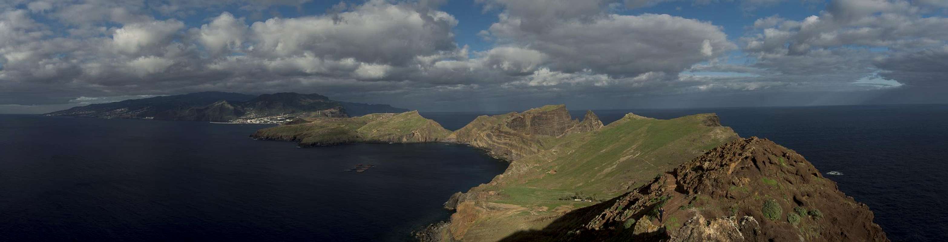
Madeira, apart from its famous wines, is best known for its wild central mountain range, which rises to almost 2000m, its deep canyons and cauldrons as well as the high plateau Paul da Serra. It is a small but very steep island and wherever you go you'll have big elevation differences to scale. To the east the main bulk of the island ends at Canical, where the mountains drop to almost sea level. Beyond and further east there remains a narrow peninsula, Ponta de Sao Lourenco, which differs significantly from the remainder of the island.
 North and south coast of Madeira at one glimpse
It is low, much lower than anything else on Madeira. Its highpoint, Pico Furado is a mere 170m high and stands at the very easternmost tip of the peninsula beyond which only a few more islet are left. Seen from afar the peninsular looks flat, a number of meadows covering a sloped plateau. Looking more closely you will see that the first impression is wrong - indeed Ponta de Sao Lourenco is as wild as the rest of the island with steep cliffs on either side of it, the sloped plateaus culminating in flat tops which drop off abruptly.
 |  |  |
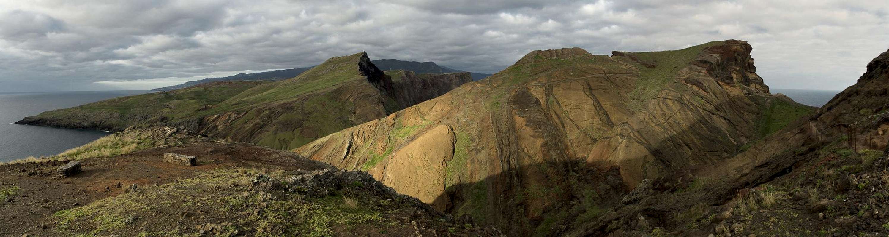
One of the most impressive spots of Ponta de Sao Lourenco is the isthmus, a narrow passage midway inside the peninsula, which drops off for 100m to both sides. The passage itself is some 5m wide, overhanging to the north but secured by cables. Beyond the isthmus there iss the plain around Casa do Sardinha,, which today is the headquarter of the natural park, which was established to protect the peninsula. And beyond the Casa there is only Pico Furado.
 The isthmus of the Sao Lourenco Peninsula
A steep staircase leads to the summit uf the easternmost point of Madeira. On top you have a fantastic view across the whole peninsula with the bulk of the island beyond. It also is the best spot to see the remainder of the small archipelago with Porto Santo to the nor-east and the Ilhas Desertas to the south-east. Pico Furado itself is twin peaked and has a rock window or cave at its base, which can be best seen from the trailhead for the hike across Ponta de Sao Lourenco. With a bit of luck you can see the sun shining through the window during sunrise of early winter mornings.
 |  |  |
In the past Pico Furado was used as a lookout for sperm whaling. Whenever the big animals were spotted the whaling fleet would set out from Canical harbour. Later the peninsula was privately owned by Manuel Bettencourt Sardinha, who built Casa do Sardinha, as a vacation home. His granddaughter sold the area back to the autonomous region of Madeira, which turned it into a natural park in 1996.
Panoramic View
  |
Getting There
 Ilheu do Guincho
Madeira can be reached from any of the major European airports. There are almost no regular flights (with the exception of some portugese airports) but quite a lot of charter flights.
The trailhead for the Sao Lourenco Peninsula is at Ponta do Buraco at the very end of the easternmost road of Madeira. You can reach it by following motorway ER101 to its end at the port of Canical (Zona Franca). From here signs lead to Ponta Sao Laurenco.
Route
 |
The hike across the Sao Lourenco Peninsula to Pico Furado and back is one of the most beautiful and spectacular hikes on Madeira - even taking into account the wonderful routes around the cauldron of Curral das Freiras. Up to the iisthmus there is a single route but beyond on the wide part of the peninsula two routes hug the northern and southern coasts. Also, there is some exposure up to the isthmus and on Pico Furado itself. However, thin railings secure these sections of the route.
Overall elevation gain on the return trip is around 400m at a length of 7.5km.
Red Tape
 The Sao Lourenco Peninsula from Pico Furado
The Sao Lourenco Peninsula has been declared a natural park in 1996. The usual restrictions apply. The volcanic rock is very brittle so that leaving trails can result in damage by erosion. Therefore you are requested to stay on the well kept trails.
Accommodation
You can find a lot of hotel rooms and apartments on Madeira. Either visit the next travel office or do an internet search. The island is small, all trailheads can be reached by car in an hour from almost anywhere on the island. Most accomodation can be found in the south of the island near Funchal and Camara de Lobos.Weather Conditions
 Sea cliffs along the north coast of Ponta de Sao Lourenco
Weather conditions cannot be predicted accurately. Madeira is located in the trade wind zone. You almost always encounter northeastern winds which carry a lot of humid air. Being forced to climb to higher altitudes this moisture condenses into clouds. This in return means that most of the time the northern part of the island is covered in clouds from altitudes of 1000m through 2000m.
Ponta de Sao Lourenco and Pico Furado are too low to be influenced by the clouds. You often have overcast skies but precipitation is rare. The peninsula is one of the driest spots on the island. On the other hand there are only few obstacles and Sao Lourenco can be a very stormy place. Especially the narrow isthmus and Pico Furado at the eastern end attract high winds.
The following table shows weather data for Funchal on the southern coast. Be careful with these data if you want to climb the summits...
| Month | Jan | Feb | Mar | Apr | May | Jun | Jul | Aug | Sep | Oct | Nov | Dec |
| Avg. day temp.[°C / °F] | 16 / 61 | 16 / 61 | 17 / 63 | 20 / 68 | 24 / 75 | 27 / 81 | 29 / 84 | 29 / 84 | 27 / 81 | 23 / 73 | 21 / 70 | 17 / 63 |
| Avg. night temp.[°C / °F] | 9 / 48 | 9 / 48 | 10 / 50 | 12 / 54 | 15 / 59 | 19 / 66 | 21 / 70 | 22 / 72 | 19 / 66 | 16 / 61 | 13 / 55 | 11 / 52 |
| Water temp.[°C / °F] | 16 / 61 | 15 / 59 | 16 / 61 | 16 / 61 | 19 / 66 | 22 / 72 | 24 / 75 | 25 / 77 | 24 / 75 | 23 / 73 | 20 / 68 | 17 / 63 |
| Rainy days | 12 | 7 | 8 | 4 | 2 | 1 | 0 | 0 | 2 | 6 | 6 | 10 |
Maps & Books
Maps
- Madeira
Tour & Trail Map
Discovery Walking Guides
1:40000
ISBN: 190494678X
Books
My recommendation is a guidebook by Rother Verlag, available in several languages. The book is an excellent hiking guide covering all the interesting areas of the island. Since it comes with small maps for each excursion it might even be used without a map to support them.
- Madeira
Rolf Götz
Rother Verlag
ISBN 978-3-7633-4811-4 (English)
ISBN 978-3-7633-4274-7 (German)
ISBN 978-3-7633-4910-4 (French)
ISBN 978-3-7633-4297-6 (Portugese)
ISBN 978-3-7633-4708-7 (Spanish)